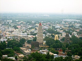
Mangalagiri is a major Sub-urban of Vijayawada in Guntur district of Indian state of Andhra Pradesh. The town is a part of Mangalagiri Tadepalli Municipal Corporation and part of Tenali revenue division. It and a part of Andhra Pradesh Capital Region. It is situated on National Highway 16 between Vijayawada and Guntur.

Machilipatnam, also known as Masulipatnam and Bandar, is a city in Krishna district of the Indian state of Andhra Pradesh. It is a municipal corporation and the administrative headquarters of Krishna district. It is also the mandal headquarters of Machilipatnam mandal in Machilipatnam revenue division of the district. The ancient port town served as the settlement of European traders from the 16th century, and it was a major trading port for the Portuguese, British, Dutch and French in the 17th century.

Gannavaram is a suburb of Vijayawada in Krishna district of the Indian state of Andhra Pradesh. It is also the mandal headquarters of Gannavaram mandal which is administered under Gudivada revenue division. It is a major suburb of Vijayawada in the North East side.Vijayawada International Airport, Medha IT Park, IT companies like HCL Tech and TechMahindra are located here.
Gudivada is a city in Krishna district of the Indian state of Andhra Pradesh. It is a municipality and the headquarters of Gudivada mandal in Gudivada revenue division. It is one of the cities in the state to be a part of Andhra Pradesh Capital Region. It is the twenty-seventh most populous city in Andhra Pradesh and the three-hundredth most populous city in India with a population of 118,167 according to the 2011 Census of India.

Nuzvid, natively spelled Nuzividu or Nuziveedu is a city in the Eluru district of the Indian state of Andhra Pradesh. It serves as the administrative headquarters for Nuzvid mandal and Nuzvid revenue division.
Gudur is a town in Tirupati district of the Indian state of Andhra Pradesh. It is a municipality and the headquarters of Gudur mandal and Gudur revenue division.

Amalapuram is a town in the Indian state of Andhra Pradesh. It is the district headquarters and the third largest town of Dr. B. R. Ambedkar Konaseema district. It is the mandal and divisional headquarters of Amalapuram mandal and Amalapuram revenue division respectively. The town is situated in the delta of konaseema.
Kanur or Kanuru is a neighborhood of Vijayawada in Krishna district of the Indian state of Andhra Pradesh.It is one of the Major educational hub of the city. As per the G.O. No. M.S.104 (dated:23-03-2017), Municipal Administration and Urban Development Department, it became a part of Vijayawada metropolitan area.

Narsipatnam is a census town in Anakapalle district of the Indian state of Andhra Pradesh. It was upgraded from a gram panchayat into municipality in 2012. The town is spread over an area of 42 km2 (16 sq mi) The resting place of the revolutionary Indian freedom fighter Alluri Sitarama Raju is located in Krishna Devi Peta village of From Narsipatnam to labasingi Village 30 km only.. labasingi most popular winter tourism place..so many Tourists enjoy -2 degree's temparature there.. Narsipatnam town is 43 km away from Tuni. And it is 72 km away from Visakhapatnam.
Pedana is a municipality and the headquarters of Pedana mandal under Machilipatnam revenue division of Krishna district of the Indian state of Andhra Pradesh. It is located at a distance of 8 km (5.0 mi) from the district headquarters, Machilipatnam.

Repalle is a town in Bapatla district of the Indian state of Andhra Pradesh. The town is one of the 12 municipalities in Bapatla district and the headquarters of Repalle mandal under the administration of Repalle revenue division. It is situated near Krishna River in the Coastal Andhra region of the state.

Thulluru is a Village in Guntur district of Indian state of Andhra Pradesh. It is located at a distance of 4 km from Krishna River and was a village in Thulluru mandal of Guntur district, prior to its denotification as gram panchayat.
Kankipadu is a suburb of Vijayawada and a in Krishna District of the Indian state of Andhra Pradesh. It is also the mandal headquarters of Kankipadu mandal in Vuyyuru revenue division.

Narasannapeta is a census town in Srikakulam district of the Indian state of Andhra Pradesh. It is the mandal headquarters of Narasannapeta mandal in Srikakulam revenue division. 43 villages are there under the administrative division of Narasannapeta.

Ramavarappadu is a residential hub located in the East-Central part of Vijayawada in NTR district of the Indian state of Andhra Pradesh.It is one of the major locality of the City.The nearest localities to Ramavarappadu are Currency Nagar ,Gunadala ,Prasadampadu
Poranki is a Major Locality of Vijayawada in Krishna district of the Indian state of Andhra Pradesh.It is the fastest growing area of the city. As per the G.O. No. M.S.104 (dated:23-03-2017), Municipal Administration and Urban Development Department, it became a part of Vijayawada metropolitan area. It is 2 KM from Penamaluru.

Guntupalli is located in western part of Vijayawada in the Indian state of Andhra Pradesh. It is a Rural area falls under Ibrahimpatnam mandal in Vijayawada revenue division of NTR district. Guntupalli Railway Wagon Workshop is located here. There is a proposal to merge this village into Vijayawada Municipal Corporation (VMC) to form a Greater Vijayawada Municipal Corporation.
Penamaluru mandal is one of the 25 mandals in Krishna district of the Indian state of Andhra Pradesh. Penamaluru Mandal is the major suburb of Vijayawada.It is under the administration of Vuyyuru revenue division and its headquarters are located at Penamaluru. The mandal lies on the banks of Krishna River and is bounded by Vijayawada (urban), Vijayawada (rural) and Kankipadu mandals. The mandal is also a part of the Andhra Pradesh Capital Region under the jurisdiction of APCRDA.
Vaddeswaram is a census town in Guntur district of the Indian state of Andhra Pradesh. It is located at a distance of 5 km (3.1 mi) from Krishna River, in Tadepalle mandal part of Mangalagiri Tadepalle Municipal Corporation part of Guntur revenue division.

Prasadampadu is a part of Vijayawada in NTR district of the Indian state of Andhra Pradesh. It is located in Vijayawada (rural) mandal of Vijayawada revenue division. As per the G.O. No. M.S.104 (dated:23-03-2017), Municipal Administration and Urban Development Department, it became a part of Vijayawada metropolitan area.
