Zimmerdale, Kansas

Last updated

Zimmerdale, Kansas
Stouffer's Railroad Map of Kansas 1915-1918 Harvey County.png
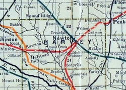
1915 Railroad Map of Harvey County
USA Kansas location map.svg
Red pog.svg
Zimmerdale
Location within the state of Kansas
Usa edcp location map.svg
Red pog.svg
Zimmerdale
Zimmerdale (the United States)
Coordinates: 38°06′10″N97°23′24″W / 38.10278°N 97.39000°W / 38.10278; -97.39000 [1]
Country United States
State Kansas
County Harvey
Township Emma
Named after Martin Zimmermann
Elevation
[1]
1,467 ft (447 m)
Time zone UTC-6 (CST)
  Summer (DST) UTC-5 (CDT)
Area code 620
FIPS code 20-80975
GNIS ID 477994 [1]

Zimmerdale is an unincorporated community in Harvey County, Kansas, United States. [1] The community is located along Old Highway 81 and a railroad line between Hesston and Newton.

Contents

History

Originally it was named Trousdale for W. Truesdale. Later, it was renamed to Zimmerdale for Martin Zimmermann. [2]

Education

The community is served by Hesston USD 460 public school district.

Transportation

The Missouri Pacific Railroad formerly provided passenger rail service along a route from Eldorado to McPherson although this had ended prior to 1946. [3] As of 2025, the nearest passenger rail station is located in Newton, where Amtrak's Southwest Chief stops once daily on a route from Chicago to Los Angeles. [4]

See also

References

  1. 1 2 3 4 U.S. Geological Survey Geographic Names Information System: Zimmerdale, Kansas
  2. "Profile for Zimmerdale, Kansas". ePodunk. Archived from the original on July 14, 2014. Retrieved June 11, 2014.
  3. "MP 1946 Timetable" (PDF). Retrieved July 27, 2025.
  4. "Amtrak Southwest Chief" . Retrieved July 27, 2025.

Further reading