Jariyan Al Batnah is a village and former municipality of Qatar. Its territory was split between the municipalities of Al Wakrah and Al Rayyan in 2004. All of Jariyan Al Batnah's districts recorded in the 2004 census – Al Karaana, Rawdat Rashed, Sawda Natheel, and Abu Samra – were distributed to the municipality of Al Rayyan thereafter. The village of Jariyan Al Batnah was also shifted to within Al Rayyan's boundaries, in Zone 83.

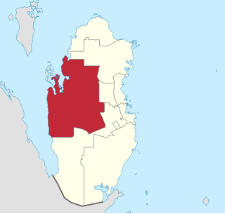
Al Rayyan is the third-largest municipality in the state of Qatar. Its primary settlement is the city of the same name, which occupies the entire eastern section and is a part of the Doha Metropolitan Area. The vast expanse of mostly undeveloped lands in the south-west also falls under the municipality's administration.
Al Shahaniya is a municipality (3299 km2) in Qatar, with its municipal seat being a city of the same name (39 km2). Formerly in the municipality of Al Rayyan, but now an independent municipality, the municipal seat was delimited in 1988 by Law No. 22. In 2014, the cabinet ratified a draft amending provisions to the 1988 law that formalized Al Shahaniya as Qatar's eighth municipality.

Bani Hajer is a district in Qatar, located in the municipality of Al Rayyan.

Rawdat Egdaim is a district in Qatar, located in the municipality of Al Rayyan.

Al Seej is a district in Qatar, located in the municipality of Al Rayyan.
Al Themaid is a district in Qatar, located in the municipality of Al Rayyan.
Zone 71 is the only zone in the municipality of Umm Salal in the state of Qatar. The main districts recorded in the 2015 population census were Bu Fasseela, Izghawa, Al Kharaitiyat, Umm Salal Ali, Umm Salal Mohammed, Saina Al-Humaidi, Umm Al Amad, and Umm Ebairiya.
Zone 82 is a zone in the municipality of Al-Shahaniya in the state of Qatar. The main district recorded in the 2015 population census was Rawdat Rashed.
Zone 52 is a zone of the municipality of Al Rayyan in Qatar. The main districts recorded in the 2015 population census were Al Luqta, Lebday, Old Al Rayyan, Al Shagub, and Fereej Al Zaeem.
Zone 53 is a zone of the municipality of Al Rayyan in Qatar. The main districts recorded in the 2015 population census were New Al Rayyan, Al Wajbah, and Muaither.
Zone 54 is a zone of the municipality of Al Rayyan in Qatar. The main districts recorded in the 2015 population census were Fereej Al Amir, Luaib, Muraikh, Baaya, Mehairja, Fereej Al Soudan.
Zone 55 is a zone of the municipality of Al Rayyan in the state of Qatar. The main districts recorded in the 2015 population census were Fereej Al Soudan, Al Waab, Al Aziziya, New Fereej Al Ghanim, Fereej Al Murra, Fereej Al Manaseer, Bu Sidra, Muaither, Al Sailiya, and Al Mearad.
Zone 56 is a zone of the municipality of Al Rayyan in the state of Qatar. The main districts recorded in the 2015 population census were Fereej Al Asiri, New Fereej Al Khulaifat, Bu Samra, Al Mamoura, Abu Hamour, Mesaimeer, and Ain Khaled.
Zone 81 is a zone of the municipality of Al Rayyan in Qatar. The main district recorded in the 2015 population census was Mebaireek.
Zone 83 is a zone of the municipality of Al Rayyan in Qatar. The main district recorded in the 2015 population census was Al Karaana.
Zone 96 is a zone of the municipality of Al Rayyan in Qatar. The main district recorded in the 2015 population census was Abu Samra.
Zone 74 is a zone of the municipality of Al Khor in the state of Qatar. The main districts recorded in the 2015 population census were Simaisma, Al Jeryan, Al Khor City.
Zone 76 is a zone of the municipality of Al Khor in the state of Qatar. The main district recorded in the 2015 population census was Al Ghuwariyah.
Zone 70 is a zone of the municipality of Al Daayen in the state of Qatar. The main districts recorded in the 2015 population census were Leabaib, Al Ebb, Jeryan Jenaihat, Al Kheesa, Rawdat Al Hamama, Wadi Al Wasaah, Al Sakhama, Al Masrouhiya, Wadi Lusail, Lusail, Umm Qarn, and Al Daayen.