
Nuaija is a district in Qatar, located in the municipality of Ad Dawhah. One of Nuaija's zones, Zone 41, was formerly known as Al Hilal West but was incorporated into Nuaija as of the 2010 census. Municipal authorities are developing district as a major mixed-use hub for south-central Doha.

Sawda Natheel is an area in Qatar, located in the municipality of Al Rayyan. It used to be part of the Jariyan al Batnah municipality before the municipality was incorporated into Al Rayyan.
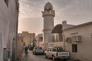
Shagra is a settlement in Qatar, located in the municipality of Al Wakrah. It was previously located in Mesaieed Municipality before the municipality was incorporated in Al Wakrah Municipality.

Fereej Kulaib is a district in Qatar, located in the municipality of Doha.
Najma is a district in Qatar, located in the municipality of Doha. Considered to be one of Doha's older districts, the bulk of Najma's commercial and office spaces are located along the arterial roads of Airport Street, C Ring Road and B Ring Road.

Lejbailat is a district in Qatar, located in the municipality of Doha. It has a relatively higher elevation compared to the rest of Doha and provides a vantage point of West Bay, one of Doha's main commercial districts. Imam Muhammad ibn Abd al-Wahhab Mosque, Qatar's state mosque, is situated in the district.

Mesaieed Industrial Area is an industrial area in Al Wakrah Municipality in the State of Qatar, approximately 40 kilometres (25 mi) south of Doha. It is a locality of the city of Mesaieed and was previously a designated district of Mesaieed Municipality before the municipality was merged with Al Wakrah Municipality.

The Doha Industrial Area is a district of Doha Municipality, Qatar. It was previously a part of the Al Rayyan Municipality, which now geographically separates it from rest of Doha Municipality. The majority of the area's workers reside in adjacent Labour City.
Zone 72 is a zone in the municipality of Al-Shahaniya in the state of Qatar. The main district recorded in the 2015 population census was Al Utouriya.
Zone 73 is a zone in the municipality of Al-Shahaniya in the state of Qatar. The main district recorded in the 2015 population census was Al Jemailiya.
Zone 80 is a zone in the municipality of Al-Shahaniya in the state of Qatar. The main district recorded in the 2015 population census was Al-Shahaniya City, the municipal seat.
Zone 82 is a zone in the municipality of Al-Shahaniya in the state of Qatar. The main district recorded in the 2015 population census was Rawdat Rashed.
Zone 84 is a zone in the municipality of Al-Shahaniya in the state of Qatar. The main district recorded in the 2015 population census was Umm Bab.
Zone 85 is a zone in the municipality of Al-Shahaniya in the state of Qatar. The main district recorded in the 2015 population census was Al Nasraniya.
Zone 86 is a zone in the municipality of Al-Shahaniya in the state of Qatar. The main district recorded in the 2015 population census was Dukhan.
Zone 81 is a zone of the municipality of Al Rayyan in the state of Qatar. The main district recorded in the 2015 population census was Mebaireek.
Zone 83 is a zone of the municipality of Al Rayyan in the state of Qatar. The main district recorded in the 2015 population census was Al Karaana.
Zone 96 is a zone of the municipality of Al Rayyan in the state of Qatar. The main district recorded in the 2015 population census was Abu Samra.
Zone 95 is a zone of the municipality of Al Wakrah in the state of Qatar. The main district recorded in the 2015 population census was Al Kharrara.
Zone 76 is a zone of the municipality of Al Khor in the state of Qatar. The main district recorded in the 2015 population census was Al Ghuwariyah.