
Goodhue County is a county in the U.S. state of Minnesota. As of the 2020 census, the population was 47,582. Its county seat is Red Wing. Nearly all of Prairie Island Indian Community is within the county.

Zumbrota is a city in Goodhue County, Minnesota, United States, along the North Fork of the Zumbro River. The population was 3,252 at the 2010 census. It promotes itself as "the only Zumbrota in the world."
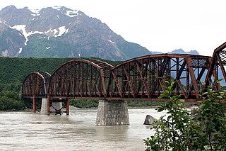
The Miles Glacier Bridge, also known as the Million Dollar Bridge, was built in the early 1900s across the Copper River fifty miles from Cordova in what is now the U.S. state of Alaska. It is a multiple-span Pennsylvania truss bridge which completed a 196-mile (315 km) railroad line for the Copper River and Northwestern Railway, built by J. P. Morgan and the Guggenheim family to haul copper from the old mining town of Kennicott, now located within the Wrangell–St. Elias National Park and Preserve, to the port of Cordova. It earned its nickname because of its $1.4 million cost, well recouped by the about $200 million worth of copper ore which was shipped as a result of its construction.

The Copper River and Northwestern Railway (CR&NW) consisted of two rail lines, the Copper River line and the Northwestern line. Michael James Heney had secured the right-of-way up the Copper River in 1904. He started building the railway from Cordova, Alaska in 1906. The town of Cordova, Alaska, was actually named by Heney on March 13, 1906, based on the original name given by Salvador Fidalgo. Both these railroads were abandoned and little remains of them. Only a 0-4-0 locomotive, "Ole", located near Goose City on a siding of the Alaska Anthracite Railroad Company is the only equipment left. Many of the holdings of the CR&NW railroad including Ole were acquired for this railroad by Mr. Clark Davis and his partners in 1908 after a major storm destroyed the Katalla area facilities in 1907. The town of Cordova would like to move Ole to a memorial site in Cordova to celebrate its role in these railroads. Ole was declared eligible for the National Register of Historic Places in 1988.

The Government Bridge or Arsenal Bridge spans the Mississippi River, connecting Rock Island, Illinois and Davenport, Iowa. The Iowa Interstate Railroad uses the upper deck of the bridge for its ex-Chicago and Rock Island Railroad route between Council Bluffs, Iowa and Chicago, Illinois. The lower deck carries automobile traffic between the two cities. It is located near Upper Mississippi Mile Marker 483, adjacent to the Mississippi River Lock and Dam No. 15. The current structure is the fourth at this location. The bridges all were built with a swing section to accommodate traffic navigating the river.

The Brown Covered Bridge is a wooden covered bridge in Shrewsbury, Vermont. Located in the northwestern part of the town, it carries Upper Cold River Road over the Cold River. It was closed to vehicular traffic in 2011 due to damage from Hurricane Irene and reopened as a National Historic Site on July 5, 2016. Built in 1880 by noted Vermont bridgewright Nichols M. Powers, it was designated a National Historic Landmark in 2014, cited as one of the finest and least-altered examples of a Town lattice truss covered bridge in the United States.
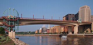
The Wabasha Street Bridge is a segmental bridge that spans the Mississippi River in downtown Saint Paul, Minnesota, United States. It was named Wabasha Street Freedom Bridge in 2002, to commemorate the first anniversary of the September 11 attacks. It actually consists of two separate bridges, one for northbound and one for southbound traffic. The use of a concrete segmental box girder bridge provided a construction advantage because no falsework needed to be built beneath the bridge.

Trunk Highway 60 (MN 60) is a 221.532-mile-long (356.521 km) highway in southern Minnesota, which runs from Iowa Highway 60 at the Iowa state line and continues east-northeast to its eastern terminus at the Wisconsin state line, where the route becomes Wisconsin Highway 25 upon crossing the Mississippi River.
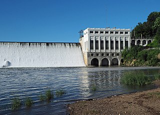
The Lake Zumbro Hydroelectric Generating Plant, also known as the City of Rochester Municipal Hydro-Electric Plant, is a hydroelectric facility on the Zumbro River in Mazeppa and Zumbro Townships, Wabasha County, Minnesota, United States. The facility consists of a gravity dam and a powerhouse, and the impoundment created is called Lake Zumbro. This dam spans 440 feet (130 m) and is 60 feet (18 m) high, creating a reservoir with about 55 feet (17 m) of hydraulic head. The facility was designed by pioneering hydroelectric engineer Hugh Lincoln Cooper (1865–1937) and was built from 1917 to 1919. It is still operated by its original owner, Rochester Public Utilities (RPU), to supply power to Rochester, Minnesota, 15 miles (24 km) to the south. The Lake Zumbro Hydroelectric Generating Plant was listed on the National Register of Historic Places in 1991 for having state-level significance in the theme of engineering. It was nominated as a representative work of Cooper—one of the nation's leading hydroelectric engineers in the early 20th century—and his only project in his home state of Minnesota.

The Cornish–Windsor Covered Bridge is a 156-year-old, two-span, timber Town lattice-truss, interstate, covered bridge that crosses the Connecticut River between Cornish, New Hampshire, and Windsor, Vermont. Until 2008, when the Smolen–Gulf Bridge opened in Ohio, it had been the longest covered bridge in the United States.

Old Blenheim Bridge was a wooden covered bridge that spanned Schoharie Creek in North Blenheim, New York, United States. With an open span of 210 feet (64 m), it had the second longest span of any surviving single-span covered bridge in the world. The 1862 Bridgeport Covered Bridge in Nevada County, California, currently undergoing repairs due to 1986 flooding is longer overall at 233 feet (71 m) but is argued to have a 208 feet (63 m) clear span. The bridge, opened in 1855, was also one of the oldest of its type in the United States. It was destroyed by flooding resulting from Tropical Storm Irene in 2011. Rebuilding of the bridge commenced in 2017 and was completed in 2018.

Kern Bridge or Yaeger Bridge crossed the Le Sueur River in Blue Earth County in the U.S. state of Minnesota. It was built in 1873 using a bowstring through truss design by the Wrought Iron Bridge Company. It was 183.5 feet (56 m) long and carried a local road. It was listed on the National Register of Historic Places in 1980 as Minnesota's only bowstring arch truss bridge and oldest road bridge still in use. However, it was closed to vehicle traffic in 1991.

The Dodd Ford Bridge is a bridge spanning the Blue Earth River about 1 mile (2 km) southwest of Amboy, Minnesota, in Blue Earth County, Minnesota.

The Contoocook Railroad Bridge is a covered bridge on the former Contoocook Valley Railroad line spanning the Contoocook River in the center of the village of Contoocook, New Hampshire, United States. It is referred to in the National Register of Historic Places as the Hopkinton Railroad Covered Bridge, for the town of Hopkinton, New Hampshire, in which the village of Contoocook is located.
The Hancock–Greenfield Bridge is a historic covered bridge carrying Forest Road over the Contoocook River at the town line between Hancock and Greenfield, New Hampshire. The New Hampshire Department of Transportation covered bridge database refers to it as County Bridge. Built in 1937, it is the first wooden covered bridge in the northeastern United States to use modern engineering techniques. The bridge was listed on the National Register of Historic Places in 1981.

The Morgan Covered Bridge, also known as the Upper Covered Bridge is a wooden covered bridge that crosses the North Branch Lamoille River in Belvidere, Vermont on Morgan Bridge Road. Built about 1887, it is one of two covered bridges in Belvidere, and one of five in a five-mile span that all cross the same river. It was listed on the National Register of Historic Places in 1974.

The Sulphite Railroad Bridge, also known locally as the Upside-Down Covered Bridge is a historic railroad bridge in Franklin, New Hampshire. The bridge was built circa 1896-7 to carry the tracks of the Boston and Maine Railroad across the Winnipesaukee River between Franklin and Tilton. The bridge is believed to be the only surviving "upside down" covered railroad bridge in the United States, in which the rail bed is laid on top of the bridge roof, whose purpose is to shelter the trusses below. The bridge was listed on the National Register of Historic Places in 1975. The bridge, unused since 1973, is not in good condition, having been subjected to graffiti, vandalism, and arson, as well as the elements.

The East Shoreham Covered Railroad Bridge is a historic covered bridge spanning the Lemon Fair River near East Shoreham, Vermont. Built in 1897 by the Rutland Railroad Company, it is the state's only surviving example of a wooden Howe truss railroad bridge. It was listed on the National Register of Historic Places in 1974.

The Centre Covered Bridge, also known as the Sanborn Covered Bridge, is a historic covered bridge, spanning the Passumpsic River next to U.S. Route 5 (US 5) north of the village of Lyndonville, Vermont. Built in 1872, it was moved to its present location and taken out of service in 1960. It is one of three surviving Paddle-Ford truss bridges in Vermont. It was listed on the National Register of Historic Places in 1974.
The West Milton Bridge is a steel girder bridge carrying Bear Trap Road across the Lamoille River in Milton, Vermont, United States. It was built as a replacement for a 1902 Pennsylvania truss bridge, which was relocated to the site of the Swanton Covered Railroad Bridge, and is listed on the National Register of Historic Places.


