Łęczna Lake District Landscape Park

Last updated
Łęczna Lake District Landscape Park
Park Krajobrazowy Pojezierze Łęczyńskie
IUCN category V (protected landscape/seascape)

Okuninka zachod.jpg

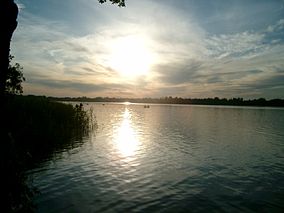
Lake Białe in the Łęczna-Włodawa Lakeland
(Pojezierze Łęczyńsko-Włodawskie)
Location Lublin Voivodeship
Area 118.16 km²
Established 1990

Łęczna Lake District Landscape Park or Łęczna Lakeland Scenic Park (Polish : Park Krajobrazowy Pojezierze Łęczyńskie) is a protected area (a Landscape Park) in eastern Poland, established in 1990, covering an area of 118.16 square kilometres (45.62 sq mi) in the geographic region called the Łęczna-Włodawa Lakeland (Pojezierze Łęczyńsko-Włodawskie) or the Łęczna-Włodawa Plain (Równina Łęczyńsko-Włodawska).

Polish language West Slavic language spoken in Poland

Polish is a West Slavic language of the Lechitic group. It is spoken primarily in Poland and serves as the native language of the Poles. In addition to being an official language of Poland, it is also used by Polish minorities in other countries. There are over 50 million Polish language speakers around the world and it is one of the official languages of the European Union.

Protected area location which receives protection because of its recognised natural, ecological or cultural landscape values

Protected areas or conservation areas are locations which receive protection because of their recognized natural, ecological or cultural values. There are several kinds of protected areas, which vary by level of protection depending on the enabling laws of each country or the regulations of the international organizations involved.

Poland republic in Central Europe

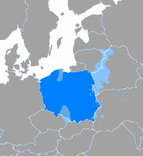
Poland, officially the Republic of Poland, is a country located in Central Europe. It is divided into 16 administrative subdivisions, covering an area of 312,696 square kilometres (120,733 sq mi), and has a largely temperate seasonal climate. With a population of approximately 38.5 million people, Poland is the sixth most populous member state of the European Union. Poland's capital and largest metropolis is Warsaw. Other major cities include Kraków, Łódź, Wrocław, Poznań, Gdańsk, and Szczecin.

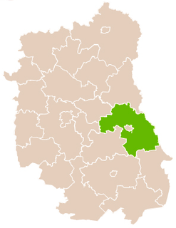
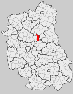
The Park lies within Lublin Voivodeship: in Lubartów County (Gmina Ostrów Lubelski, Gmina Uścimów) and Łęczna County (Gmina Ludwin, Gmina Puchaczów). [1]

Lublin Voivodeship Voivodeship in Poland

Lublin Voivodeship, or Lublin Province, is a voivodeship, or province, located in southeastern Poland. It was created on January 1, 1999, out of the former Lublin, Chełm, Zamość, Biała Podlaska and (partially) Tarnobrzeg and Siedlce Voivodeships, pursuant to Polish local government reforms adopted in 1998. The province is named after its largest city and regional capital, Lublin, and its territory is made of four historical lands: the western part of the voivodeship, with Lublin itself, belongs to Lesser Poland, the eastern part of Lublin Area belongs to Red Ruthenia, and the northeast belongs to Polesie and Podlasie.

Lubartów County County in Lublin, Poland

Lubartów County is a unit of territorial administration and local government (powiat) in Lublin Voivodeship, eastern Poland. It was established on January 1, 1999, as a result of the Polish local government reforms passed in 1998. Its administrative seat and largest town is Lubartów, which lies 25 kilometres (16 mi) north of the regional capital Lublin. The county also contains the towns of Kock, lying 23 km (14 mi) north-west of Lubartów, and Ostrów Lubelski, 18 km (11 mi) east of Lubartów.

Gmina Ostrów Lubelski Gmina in Lublin, Poland

Gmina Ostrów Lubelski is an urban-rural gmina in Lubartów County, Lublin Voivodeship, in eastern Poland. Its seat is the town of Ostrów Lubelski, which lies approximately 18 kilometres (11 mi) east of Lubartów and 34 km (21 mi) north-east of the regional capital Lublin.

The best known recreational area within the Łęczna Lakeland surrounds the White lake (Jezioro Białe Włodawskie), with the resort town called Okuninka.

Okuninka Village in Lublin, Poland

Okuninka is a village in the administrative district of Gmina Włodawa, within Włodawa County, Lublin Voivodeship, in eastern Poland, close to the border with Belarus. It is located approximately 6 kilometres (4 mi) south of Włodawa and 74 km (46 mi) north-east of the regional capital Lublin.

See also

Related Research Articles

Łęczna Place in Lublin, Poland

Łęczna is a town in eastern Poland with 19,780 inhabitants (2014), situated in Lublin Voivodeship. It is the seat of Łęczna County and the smaller administrative district of Gmina Łęczna. The town is located in northeastern corner of historic province of Lesser Poland. Łęczna tops among the hills of the Lublin Upland, at the confluence of two rivers—the Wieprz, and the Świnka. On December 31, 2010, the population of the town was 20,706. Łęczna does not have a rail station, the town has been placed on a national Route 82 from Lublin to Włodawa. And shall be considered as a start point to Kameralne Pojezierze, as the town has decided to rebrand the lakeland district, from Pojezierze Łęczyńsko-Włodawskie, or Pojezierze Łęczyńskie, to Kameralne Pojezierze.

Sobibór, Lublin Voivodeship Village in Lublin, Poland

Sobibór is a village in the administrative district of Gmina Włodawa, within Włodawa County, Lublin Voivodeship, in eastern Poland. It lies close to the Bug River, which forms the border with Belarus and Ukraine.

Masurian Lake District Place in Poland

The Masurian Lake District or Masurian Lakeland is a lake district in northeastern Poland within the geographical region of Masuria, in the past inhabited by Masurians who spoke the Masurian dialect. It contains more than 2,000 lakes. The district had been elected as one of the 28 finalists of the New 7 Wonders of Nature.

Polesie National Park national park of Poland

Polesie National Park is a National Park in Lublin Voivodeship, eastern Poland, in the Polish part of the historical region of Polesie. Created in 1990 over an area of 48.13 square kilometres, it covers a number of former peat-bog preserves: Durne Bagno, Jezioro Moszne, Jezioro Długie, Torfowisko Orłowskie. In 1994 its size was augmented by the addition of Bagno Bubnów, a swampy terrain adjacent to the park. Currently, the park occupies 97.62 km2 (37.69 sq mi), of which forests make up 47.8 km², and water and wastelands 20.9 km².

Chełm County County in Lublin, Poland

Chełm County is a unit of territorial administration and local government (powiat) in Lublin Voivodeship, eastern Poland, on the border with Ukraine. It was established on January 1, 1999, as a result of the Polish local government reforms passed in 1998. Its administrative seat is the city of Chełm, although the city is not part of the county. The only town in Chełm County is Rejowiec Fabryczny, which lies 17 km (11 mi) west of Chełm.

Włodawa County County in Lublin, Poland

Włodawa County is a unit of territorial administration and local government (powiat) in Lublin Voivodeship, eastern Poland, on the border with Ukraine and Belarus. It was established on January 1, 1999, as a result of the Polish local government reforms passed in 1998. Its administrative seat and only town is Włodawa, which lies 76 kilometres (47 mi) north-east of the regional capital Lublin.

Łęczna County County in Lublin, Poland

Łęczna County is a unit of territorial administration and local government (powiat) in Lublin Voivodeship, eastern Poland. It was established on January 1, 1999, as a result of the Polish local government reforms passed in 1998. Its administrative seat and only town is Łęczna, which lies 23 kilometres (14 mi) east of the regional capital Lublin.

Gmina Uścimów Gmina in Lublin, Poland

Gmina Uścimów is a rural gmina in Lubartów County, Lublin Voivodeship, in eastern Poland. Its seat is the village of Uścimów, which lies approximately 24 kilometres (15 mi) east of Lubartów and 36 km (22 mi) north-east of the regional capital Lublin.

Gmina Ludwin is a rural gmina in Łęczna County, Lublin Voivodeship, in eastern Poland. Its seat is the village of Ludwin, which lies approximately 4 kilometres (2 mi) north of Łęczna and 25 km (16 mi) east of the regional capital Lublin.

Gmina Puchaczów is a rural gmina in Łęczna County, Lublin Voivodeship, in eastern Poland. Its seat is the village of Puchaczów, which lies approximately 6 kilometres (4 mi) east of Łęczna and 29 km (18 mi) east of the regional capital Lublin.

Gmina Stary Brus is a rural gmina in Włodawa County, Lublin Voivodeship, in eastern Poland. Its seat is the village of Stary Brus, which lies approximately 20 kilometres (12 mi) south-west of Włodawa and 57 km (35 mi) north-east of the regional capital Lublin.

Ludwin Village in Lublin, Poland

Ludwin is a village in Łęczna County, Lublin Voivodeship, in eastern Poland. It is the seat of the gmina called Gmina Ludwin. It lies approximately 4 kilometres (2 mi) north of Łęczna and 25 km (16 mi) east of the regional capital Lublin.

Iława Lake District Landscape Park

Iława Lake District Landscape Park or Iława Lakeland Scenic Park is a protected area in northern Poland. Established in 1993, the park is part of the geographic region called Pojezierze Iławskie. It includes Jeziorak lake and the Lasy Iławskie spread out on the west side of Jeziorak. It covers the area of 250.45 square kilometres (96.70 sq mi).

Polesie Landscape Park is a protected area in eastern Poland, established in 1983, covering an area of 51.13 square kilometres (19.74 sq mi).

Sobibór Landscape Park landscape park of Poland

Sobibór Landscape Park is a protected area created in Lublin Voivodeship, eastern Poland in 1983. It takes its name from the village of Sobibór.

Leopoldów, Łęczna County Village in Lublin, Poland

Leopoldów is a village in the administrative district of Gmina Łęczna, within Łęczna County, Lublin Voivodeship, in eastern Poland. It lies approximately 4 kilometres (2 mi) south of Łęczna and 22 km (14 mi) east of the regional capital Lublin.

Kobyłki, Lublin Voivodeship Village in Lublin, Poland

Kobyłki is a village in the administrative district of Gmina Ludwin, within Łęczna County, Lublin Voivodeship, in eastern Poland. It lies approximately 8 kilometres (5 mi) north-east of Ludwin, 11 km (7 mi) north-east of Łęczna, and 33 km (21 mi) north-east of the regional capital Lublin. Name of Kobyłki, the most closely can be translated as "Mares". In mid 90's the area south of Kobyłki had enjoyed minor mining damage, the cause was quite close neighborhood of Bogdanka Coal Mine and its large-scale operations, and as the result the least urbanized parts of the village are planned to be sunk, seamlessly expanding an artificial lake. The area is rich in open landscapes, natural resources, including number of fish, and rare species of birds living on Pojezierze Łęczyńskie. The area has been focused on sustainable development, observing a slight decrease in the reliance on agriculture, in favor of agrotourism serving residents of near-by Łęczna, and Lublin area. The community hosts number of farmers who grow apples, strawberries, pears, currants, raspberries, gooseberries, tobacco, corn, beer hops and various other crops.

Krychów Village in Lublin, Poland

Krychówpronounced [ˈkrɨxuv] is a village neighbourhood in the administrative district of Gmina Hańsk, within Włodawa County, Lublin Voivodeship, in eastern Poland. In 1975–98 the settlement belonged administratively to Chełm Voivodeship.

References

Coordinates: 51°31′08″N22°57′14″E / 51.5189°N 22.9539°E / 51.5189; 22.9539

Geographic coordinate system Coordinate system

A geographic coordinate system is a coordinate system that enables every location on Earth to be specified by a set of numbers, letters or symbols. The coordinates are often chosen such that one of the numbers represents a vertical position and two or three of the numbers represent a horizontal position; alternatively, a geographic position may be expressed in a combined three-dimensional Cartesian vector. A common choice of coordinates is latitude, longitude and elevation. To specify a location on a plane requires a map projection.