Štrigova

Last updated • 4 min readFrom Wikipedia, The Free Encyclopedia
Štrigova
Municipality
Crkva sv. Jeronima, Strigova (Croatia) - sjeverozapad.jpg
Church of Saint Jerome
Croatia location map.svg
Red pog.svg
Štrigova
Location of Štrigova in Croatia
Coordinates: 46°30′04″N16°17′06″E / 46.50111°N 16.28500°E / 46.50111; 16.28500
Country Flag of Croatia.svg  Croatia
County Međimurje
Government
  Municipal mayorStanislav Rebernik (SDP)
Area
[1]
  Municipality39.3 km2 (15.2 sq mi)
  Urban
2.1 km2 (0.8 sq mi)
Population
 (2021) [2]
  Municipality2,357
  Density60/km2 (160/sq mi)
   Urban
436
  Urban density210/km2 (540/sq mi)
Time zone UTC+1 (CET)
  Summer (DST) UTC+2 (CEST)
Postal code
40312 Štrigova
Website opcinastrigova.hr

Štrigova (Hungarian : Stridóvár; outdated German name: Stridau) is a village and municipality in Međimurje County, in northern Croatia.

Contents

History

Saint Jerome chapel in 17th century Gabriel Bucelin Stridon Kapelle und Quelle des hl Hieronymus 1644.jpg
Saint Jerome chapel in 17th century

Oldest archaeological finds in Štrigova municipality are from Roman period. Burial mounds and fragments of pottery were found in the hamlet of Trnovčak. Fragments of the Roman roads were found at the same locality. [3] [4]

The settlement Štrigova is first time mentioned in 1271 as Castr. Strigo (English: Fort Strigo). [5] During that time fort was in possession of Arnold of Stridó. [6] In year 1290 Andrew the Venetian, later king of Hungary and Croatia, was captured in fort Štrigova by Arnold of Stridó, and was sent to Vienna in captivity. [7] In year 1334 Štrigova was recorded as Catholic parish named Sancte Marie Magdalene de Strigo in Census of parishes of Zagreb Diocese. [8] From the late Middle Ages until the beginning of the 20th century, Štrigova has the rights of a Market town. [9]

During the 15th century feudal proprietor of Međimurje Frederick II, Count of Celje built the wooden chapel of saint Jerome in Štrigova. In year 1447 Papal bull Gloriosus Deus in sanctis suis (English: God is glorius in his Saints) was promulgated by Pope Nicholas V for Saint Jerome church in Štrigova. In that document Štrigova is mentioned as birthplace of Saint Jerome. [10] But claims about birthplace of Saint Jerome are disputed by some scholars.

In year 1931 Štrigova municipality was separated from Čakovec District and the rest of Međimurje and placed under authority of Ljutomer District in Drava Banovina. [11] In April 1941 Međimurje was occupied by Hungarian Army, but Štrigova were occupied by German Army. In June 1941, at the Hungarian request, Štrigova is again reincorporated in Međimurje. [12]

In April 1945 former municipality Štrigova provisionally became a part of Yugoslav Federal republic of Slovenia. In 1946 Štrigova municipality was divided between People's Republics Croatia and Slovenia. [13] Villages Banfi, Grabrovnik, Jalšovec, Leskovec, Prekopa, Robadje, Stanetinec, Sveti Urban and Štrigova became part of Croatia, and Gibina, Globoka, Kopriva, Razkrižje, Šafarsko, Šprinc, and Veščica became part of Slovenia. In year 1947 in forest near Štrigova Yugoslavian secret police (OZNA) murdered dozens of members of anticommunist guerrilla called Crusaders (Croatian: Križari). [14]

In year 1992 Štrigova regained the status of municipality. [15]

Geography

Main Street in Strigova Strigova (Croatia) - glavna ulica.jpg
Main Street in Štrigova

Štrigova is located in part of Međimurje called Gornje Međimurje at border with Slovenia. Village of Štrigova, municipality centre, is about 19 kilometres northwest from Čakovec, and some 110 kilometres north of Zagreb. The municipality covers an area of 39.21 km2. [16]

Landscape of Štrigova consist of low hills called Međimurske gorice, covered with vineyards, orchards and woodlands. Međimurske gorice are extension of Slovenske gorice. [17] At 341 metres, Mađerkin breg is the highest hill in municipality, and also a popular viewpoint. [18] River Mura touches the border of municipality at its northernmost part.

Štrigova is located on road that connects county seat Čakovec with town of Ljutomer in Slovenia. There are two border crossing with Slovenia in municipality, called Banfi and Bukovje. [19]

Demographics

In the 2011 census, the municipality had a population of 2,766 in 10 villages. [20] Štrigova is experiencing population decline since the 1950s. The majority of inhabitants are Croats making up 94% of population and most significant minority are Slovenes (4%). [21]

Historical population
YearPop.±%
19214,492    
19314,873+8.5%
19485,157+5.8%
19535,115−0.8%
19614,606−10.0%
YearPop.±%
19714,315−6.3%
19813,703−14.2%
19913,346−9.6%
20013,221−3.7%
20112,766−14.1%
[20] [22]

Settlements

VillagePopulation [20]
(2011)
Banfi 262
Grabrovnik 274
Jalšovec 144
Leskovec 109
Prekopa 234
Robadje 159
Stanetinec 195
Sveti Urban 481
Štrigova443
Železna Gora 465
TOTAL2.766

Economy

The economy of the municipality is largely focused on its agriculture. Many hills in the municipality were planted with vineyards and the production of wine is a major business in the municipality. There are many wine cellars throughout the municipality, most of which are privately owned, but there is also a large communally-owned wine cellar in Štrigova.

Cattle breeding and dairy products are also an important part of the economy of the municipality, although to a lesser extent in comparison with the production of wine, as well as rural tourism.

Culture

The Church of St. Jerome was rebuilt in 1749 by famous artist Ivan Ranger following the demolition of the original 15th-century-built chapel by an earthquake in 1738. There are also two historical castles located in the municipality. The castle in Banfi (Bánfihegy) was built by Count Bánffy in 1373, and Tkalec Castle on Kalec hill is believed to be built by local Paulines in the 18th century.

Related Research Articles

<span class="mw-page-title-main">Međimurje County</span> County in northern Croatia

Međimurje County is a triangle-shaped county in the northernmost part of Croatia, roughly corresponding to the historical and geographical region of Međimurje. It is the smallest Croatian county by size, as well as the most densely populated. The county's seat and main urban centre is Čakovec.

<span class="mw-page-title-main">Čakovec</span> City in Međimurje, Croatia

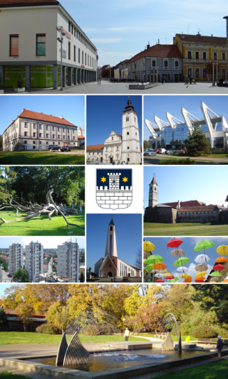
Čakovec is a city in Northern Croatia, located around 90 kilometres north of Zagreb, the Croatian capital. Čakovec is both the county seat and the largest city of Međimurje County, the northernmost, smallest and most densely populated Croatian county.

<span class="mw-page-title-main">Mursko Središće</span> Town in Međimurje, Croatia

Mursko Središće is the northernmost town in Croatia, located at 46.509°N 16.441°E and one of the oldest localities in Međimurje County.

<span class="mw-page-title-main">Nedelišće</span> Municipality in Međimurje, Croatia

Nedelišće is a village in Međimurje County, in northern Croatia, and the seat of the Municipality of Nedelišće, which also includes 10 other villages in the south-western part of Međimurje County.

<span class="mw-page-title-main">Drava Banovina</span>

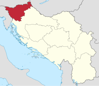
The Drava Banovina or Drava Banate, was a province (banovina) of the Kingdom of Yugoslavia between 1929 and 1941. This province consisted of most of present-day Slovenia and was named for the Drava River. The capital city of the Drava Banovina was Ljubljana.

<span class="mw-page-title-main">Gornji Mihaljevec</span> Municipality in Međimurje, Croatia

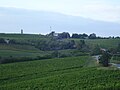
Gornji Mihaljevec is a village and municipality in Međimurje County, in northern Croatia.

<span class="mw-page-title-main">Selnica, Međimurje County</span> Municipality in Međimurje, Croatia

Selnica is a village and municipality in Međimurje County, in northern Croatia.

<span class="mw-page-title-main">Sveti Juraj na Bregu</span> Municipality in Međimurje, Croatia

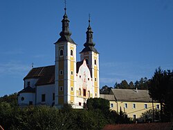
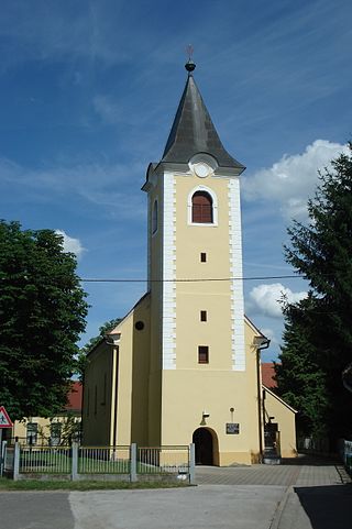
Sveti Juraj na Bregu is a municipality in Međimurje County, Croatia.

<span class="mw-page-title-main">Sveti Martin na Muri</span> Municipality in Međimurje, Croatia

Sveti Martin na Muri is a village and municipality in Međimurje County, in northern Croatia.

Črečan is a village in northern Croatia, part of the Nedelišće municipality within Međimurje County.

Trnovec is a village in northern Croatia, part of the Nedelišće municipality within Međimurje County.

<span class="mw-page-title-main">Međimurje (region)</span> Region in Croatia

Međimurje is a small historical and geographical region in Northern Croatia comprising the area between the two large rivers, Mura and Drava, and roughly corresponding to the administrative division of Međimurje County.

<span class="mw-page-title-main">Banfi, Croatia</span> Village in Međimurje County, Croatia

Banfi is a village in northern Croatia, part of the Štrigova municipality within Međimurje County. The village is located at the border with Slovenia.

<span class="mw-page-title-main">Robadje</span> Village in Međimurje County, Croatia

Robadje is a village in northern Croatia, part of the Štrigova municipality within Međimurje County. The village is located at the border with Slovenia.

<span class="mw-page-title-main">Leskovec, Croatia</span> Village in Međimurje County, Croatia

Leskovec is a village in northern Croatia, part of the Štrigova municipality within Međimurje County. Village is located near the border with Slovenia.

<span class="mw-page-title-main">Železna Gora</span> Village in Međimurje County, Croatia

Železna Gora is a village in northern Croatia, part of the Štrigova municipality within Međimurje County.

<span class="mw-page-title-main">Lapšina</span> Village in Međimurje County, Croatia

Lapšina is a village in northern Croatia, part of the Sveti Martin na Muri municipality within Međimurje County.

<span class="mw-page-title-main">Žabnik, Međimurje County</span> Village in Međimurje County, Croatia

Žabnik is the northernmost settlement in Croatia, located in the Sveti Martin na Muri municipality of Međimurje County.

<span class="mw-page-title-main">Grabrovnik</span> Village in Međimurje County, Croatia

Grabrovnik is a village in northern Croatia, part of the Štrigova municipality within Međimurje County.

<span class="mw-page-title-main">Međimurje under Hungarian rule</span>

Međimurje under Hungarian rule is the historical period of Međimurje, the northernmost part of Croatia, from the Early modern period to Late modern period, during which it was an integral part of Zala County in Hungary. It was a centuries-old aspiration of the Hungarian rulers that came true in 1720, as Međimurje was acquired by Michael Johann III. Althann (1679–1727), a Habsburg Count and member of the House of Althann, an ancient German noble family. Until then, although in the possession of Croatian, Hungarian and Austrian noblemen, Međimurje was mostly part of the Varaždin County, which formally belonged to the medieval Kingdom of Slavonia or early modern Kingdom of Slavonia, one of Croatian lands. From 1527 the entire territory fell under Habsburg Monarchy and after the formation of Croatian Military Frontier on parts of the Croatian territory, Međimurje remained outside it and was, as before, under the administration of the Ban (Banus) of Croatia.

References

  1. Register of spatial units of the State Geodetic Administration of the Republic of Croatia. Wikidata   Q119585703.
  2. "Population by Age and Sex, by Settlements" (xlsx). Census of Population, Households and Dwellings in 2021. Zagreb: Croatian Bureau of Statistics. 2022.
  3. Tomičič, Željko (February 1982). "Arheološka istraživanja antičke nekropole kod sela Trnovčaka u Međimurju". Muzejski Vjesnik (in Croatian). 7. Gradski muzej Varaždin: 41–47. Retrieved October 4, 2020 via HRČAK.
  4. Marciuš, Branka (2010). "Trnovčak" (PDF). Hrvatski arheološki godišnjak (in Croatian). 5. Ministarstvo kulture RH: 225–227. Retrieved October 4, 2020.
  5. Frančić, Anđela (2012). "Ojkonim Štrigova kroz stoljeća" [The settlement name Štrigova throughout the centuries]. Folia Onomastica Croatica. 50. Hrvatska akademija znanosti I umjetnosti: 42. Retrieved October 5, 2020 via HRČAK.
  6. Srša, Ivan (2017). "Crtice o Međimurskom srednjovjekovlju" [Notes on the Međimurean Middle Ages]. Kaj: časošis za književnost, umjetnost I kulturu (in Croatian). 21. Kajkavsko spravišče I umjetnosti: 82. Retrieved October 5, 2020 via HRČAK.
  7. Zsoldos, Attila (2003). "III. András". In Szovák, Kornél; Szentpéteri, József; Szakács, Margit (eds.). Szent István és III. András[Saint Stephen and Andrew III] (in Hungarian). Kossuth Kiadó. pp. 119–227. ISBN   963-09-4461-8.
  8. Vugrinčić, Benjamin (2015). Župe na području Međimurja u 14. i 15. stoljeću [Parishes in the Međimurje area during 14th and 15th century] (Thesis) (in Croatian). pp. 57–59. Retrieved October 5, 2020.
  9. Kalšan, Vladimir (2006). Međimurska povijest[History of Međimurje] (in Croatian). Čakovec: Vladimir Kalšan. p. 182. ISBN   953-98293-1-3.
  10. Berljak, Matija (2019). Bula pape Nikole V.[Bull promulgated by pope Nicholas V]. Grafika Markulin. pp. 107–108. ISBN   978-953-6406-32-6.
  11. Kalšan, Vladimir (2006). Međimurska povijest[History of Međimurje] (in Croatian). Čakovec: Vladimir Kalšan. p. 285. ISBN   953-98293-1-3.
  12. Kalšan, Vladimir (2006). Međimurska povijest[History of Međimurje] (in Croatian). Čakovec: Vladimir Kalšan. p. 377. ISBN   953-98293-1-3.
  13. Grgić, Stipica (2017). "The Štrigova and Razkrižje Micro-region in the First Half of the 20th Century". Contributions to Contemporary History. 57. Inštitut za novejšo zgodovino. Retrieved October 6, 2020.
  14. Kalšan, Vladimir (2006). Međimurska povijest[History of Međimurje] (in Croatian). Čakovec: Vladimir Kalšan. pp. 378–380. ISBN   953-98293-1-3.
  15. "2018 – Statistical Yearbook of the Republic of Croatia" (PDF). Croatian Bureau of Statistics. December 2018. p. 74. Retrieved 6 October 2020.
  16. "Prostorni plan uređenja općine Štrigova" (PDF) (in Croatian). Zavod za prostorno uređenje Međimurske Županije. October 2005. p. 4. Archived from the original (PDF) on 2007-10-10. Retrieved 2016-05-18.
  17. Sever, Martin (2018). Analiza drenažne mreže Međimurskih gorica [Analysis of drainage system of Međimurske gorice] (Thesis) (in Croatian). pp. 3–4. Retrieved October 11, 2020.
  18. Heric, Sanja (May 8, 2020). "Mađerkin breg nazvan je po plesačici iz Budimpešte". Međimurske novine (in Croatian).
  19. "Granični prijelazi na području policijske uprave Međimurske". Policijska uprava Međimurska. Retrieved October 12, 2020.
  20. 1 2 3 "Population by Age and Sex, by Settlements, 2011 Census: Štrigova". Census of Population, Households and Dwellings 2011. Zagreb: Croatian Bureau of Statistics. December 2012.
  21. "Population by Ethnicity, by Towns/Municipalities, 2011 Census: County of Međimurje". Census of Population, Households and Dwellings 2011. Zagreb: Croatian Bureau of Statistics. December 2012.
  22. "Naselja i stanovništvo Republike Hrvatske". Croatian Bureau of Statistics . Retrieved 12 October 2020.[ permanent dead link ]