
Snowdonia is a mountainous region in northwestern Wales and a national park of 823 square miles (2,130 km2) in area. It was the first to be designated of the three national parks in Wales, in 1951. It contains the highest peaks in the United Kingdom outside Scotland.

Powys is a principal area and county, and one of the preserved counties of Wales. It is named after the Kingdom of Powys which was a Welsh successor state, petty kingdom and principality that emerged during the Middle Ages following the end of Roman rule in Britain.

Middlesbrough is a large town in North Yorkshire, England. It is on the River Tees's southern bank, west of Redcar and east of Stockton-on-Tees. The Borough of Middlesbrough is governed from the town.

Wrexham is a large market town and the administrative centre of Wrexham County Borough in Wales. It is located between the Welsh mountains and the lower Dee Valley neighbouring the English county of Cheshire. Historically part of Denbighshire, the town became part of Clwyd in 1974 and has been the principal centre of Wrexham County Borough since 1996.

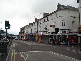
Rhyl is a seaside resort and community in the Welsh county of Denbighshire. It lies within the historic boundaries of Flintshire, on the north-east coast of Wales at the mouth of the River Clwyd. To the west is the suburb of Kinmel Bay and the resort of Towyn beyond, to the east Prestatyn, and to the south Rhuddlan. At the 2011 Census, Rhyl had a population of 25,149, with Rhyl-Kinmel Bay having 31,229. The Abergele–Rhyl–Prestatyn conurbation numbers over 60,000. Once an elegant Victorian resort, an influx from Liverpool and Manchester after the Second World War changed the town's face. It had declined sharply by 1990, but has since been improved by major regeneration investments. Several million pounds of European Union funding to the Welsh Government has gone on developing the seafront.
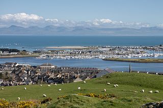
Pwllheli is a market town and community of the Llŷn Peninsula in Gwynedd, north-western Wales. It had a population of 4,076 in 2011 of whom a large proportion, 81%, are Welsh speaking. Pwllheli is the place where Plaid Cymru was founded. It is the birthplace of the Welsh poet Sir Albert Evans-Jones.

North Wales, also known as the North of Wales, is a geographic region of Wales, encompassing its northernmost areas. It borders Mid Wales to the south, England to the east, and the Irish Sea to the north and west. The area is highly mountainous and rural, with Snowdonia National Park and the Clwydian Range, known for its mountains, waterfalls and trails, located wholly within the region. Its population is more concentrated in the north-east, and northern coastal areas of the region, whilst significant Welsh-speaking populations are situated in its western and rural areas. North Wales is imprecisely defined, lacking any defined defintion or administrative structure. For the public purposes of health, policing and emergency services, and for statistical, economic and cultural purposes, North Wales is commonly defined administratively as its six most northern principal areas, but other defintions of the geographic region exist, with Montgomeryshire historically considered to be part of the region.
Canton is an inner-city district and community in the west of Cardiff, capital of Wales, lying 2 miles (3.2 km) west of the city's civic centre. Canton is one of the most ethnically diverse of Cardiff's suburbs, with a significant Pakistani and Indian population. The total population of Canton increased to 14,304 at the 2011 census. It is also the most Welsh-speaking district of central Cardiff, with 19.1% of the population speaking Welsh.
Morriston is a community in the City and County of Swansea, Wales and falls within the Morriston ward. It is the largest community in Swansea county.

The Brent Reservoir is a reservoir in North West London. It straddles the boundary between the boroughs of Brent and Barnet and is owned by the Canal & River Trust. The reservoir takes its informal name from a public house called The Welsh Harp, which stood nearby until the early 1970s. It is a 68.6-hectare (170-acre) biological Site of Special Scientific Interest (SSSI), the only SSSI in either borough and among more than 30 SSSIs in Greater London.

Penygroes is a village in Gwynedd, Wales. The village is located to the south of Caernarfon, and north of Porthmadog, by the A487 road. Penygroes' population stands at 1,793 at the 2011 census, of which 88% are Welsh-speaking, making it one of the most predominantly Welsh-speaking areas of the country. The population of Llanllyfni community, which includes Penygroes and Llanllyfni village, which practically adjoins Penygroes, plus Talysarn, is 4,135 according to the 2011 census.

Betws Garmon is a community and small hamlet outside Waunfawr and near Beddgelert in Gwynedd, Wales. It has a population of 249.

Gray's Inn Road is an important road in the Bloomsbury district of Central London, in the London Borough of Camden. The road begins at the City of London boundary, where it bisects High Holborn, and ends at King's Cross and St. Pancras Station.

Holme Circle is a neighborhood in Northeast Philadelphia. It is located in the loop of Pennypack Creek at Holme Avenue and Welsh Road. The area is generally composed of two-story twin homes north of the Holme Circle, one-story twins southeast of the Circle and single homes south of Welsh Road and Holme Avenue. St Jerome Parish serves the area; the Robert B. Pollock Elementary School is at Welsh Road and Tolbut Street.
Cemmaes Road is a village in Powys, Wales. It is in the community of Glantwymyn.

The England–Wales border, sometimes referred to as the Wales–England border or the Anglo–Welsh border, runs for 160 miles (260 km) from the Dee estuary, in the north, to the Severn estuary in the south, separating England and Wales.

Mynydd Epynt is an upland area of Mid Wales within the county of Powys, Wales. It is bounded to the south by the upper section of the valley of the River Usk and the Brecon Beacons National Park, to the north by the valley of the Afon Irfon, and to the east by the valley of the River Wye. Its western boundary is less distinct but lies eastward of the A483 Llandovery to Llanwrtyd Wells road. Its character is that of an extensive though dissected moorland plateau lying between 400 and 450m above sea level and whose highest point of 478m (1,568 ft) is reached at an unnamed rise at OS grid ref SN 961464.

Stwnsh is a strand of Welsh-language children's television programming, aimed at children between the ages of seven and thirteen. Stwnsh was launched on Monday 26 April 2010, replacing the former Welsh-language children's strand, Planed Plant. Stwnsh is broadcast on the Welsh-language television channel S4C every weekday, from 4:00pm to 6:00pm, and on Saturdays from 9:00am to 11:00am.

Road signs in Wales follow the same design principles as those in other parts of the United Kingdom. All modern signs feature both Welsh- and English-language wording, with the Welsh first in many areas.

