
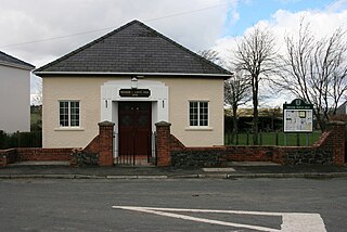
Ystradfellte is a village and community in Powys, Wales, about 6 miles (10 km) north of Hirwaun, with 556 inhabitants. It belongs to the historic county of Brecknockshire (Breconshire) and the Fforest Fawr area of the Brecon Beacons National Park, beside the Afon Mellte river. The village is linked by minor roads with Heol Senni to the north and the A4059 north of Penderyn, and with Pontneddfechan, which lies in the community, at the head of the Vale of Neath to the south.

Afon Mellte or the River Mellte is a river in south Wales. It is formed by the confluence of the Afon Llia and the Afon Dringarth. It then flows south through the village of Ystradfellte to Pontneddfechan where it joins with the Nedd Fechan to become the River Neath. The river derives its name from 'mellt' - the Welsh word for 'lightning' - after its tendency to rise and fall rapidly in response to heavy rainfall.

Coelbren is a small rural village within the community of Tawe Uchaf in southernmost Powys, Wales. It lies on the very northern edge of the South Wales Coalfield some six miles north-east of Ystradgynlais and just outside the southern boundary of the Brecon Beacons National Park. It is known for Henrhyd Falls, a 27m high waterfall which serves as a National Trust-managed visitor attraction on the Nant Llech. To the east of the village flows the Afon Pyrddin which plunges over two more spectacular falls.
The Nedd Fechan is a river almost wholly within the county of Powys, Wales, currently administered as part of the unitary authority of Powys. It rises on the eastern slopes of Fan Gyhirych in the Fforest Fawr section of the Brecon Beacons National Park and flows south for 7 miles (12 km) to join with the Afon Mellte at Pontneddfechan, their combined waters continuing as the River Neath to the sea near Swansea. The only significant tributary of the Nedd Fechan is the Afon Pyrddin which joins it at Pwll Du ar Byrddin. Downstream of this confluence it forms the boundary between Powys to its east and Neath Port Talbot to its west.
The Afon Llia is a short river in Powys, Wales, and which is wholly contained within the Brecon Beacons National Park.
The Afon Dringarth is a river in Powys, Wales and wholly contained within the Brecon Beacons National Park. Its headwater streams drain the eastern slopes of Fan Dringarth, the southern slopes of Craig Cerrig-gleisiad and the western slopes of Fan Fawr. The river flows south-southwest for about 6 km / 3.5 mi to its confluence with the Afon Llia one mile north of the village of Ystradfellte, continuing south as the Afon Mellte. The river may derive its name from the hill immediately to its west, Fan Dringarth.

Fan Nedd is a mountain in the Fforest Fawr area of the Brecon Beacons National Park in Wales. In common with the rest of the Fforest Fawr uplands it is within the county of Powys.

Fan Llia is a subsidiary summit of Fan Fawr in the Fforest Fawr section of the Brecon Beacons National Park, Wales. In common with other peaks in the Fforest Fawr uplands it lies within the county of Powys.

The Afon Crai is a river in Powys, Wales rising in the Fforest Fawr section of the Brecon Beacons National Park and flowing north into the River Usk. The headwaters known as Blaen-crai flow north from Bwlch Bryn-rhudd, a col between the Crai valley and the upper Swansea Valley for 2 km into the Cray Reservoir. The river emerges from below the dam to flow a further 8 km through the dispersed settlement of Crai.

The Afon Senni is a river in Powys, Wales which rises in the Fforest Fawr section of the Brecon Beacons National Park and flows northwards for 11 kilometres (7 mi) to a confluence with the River Usk at Sennybridge.

The Afon Cynrig is a river in Powys, Wales whose headwaters rise in the central Brecon Beacons and flow northwards to join the River Usk at Abercynrig just east of Brecon.

The Grwyne Fawr is a river in the Brecon Beacons National Park in south Wales. A section of it forms the administrative border between Powys and Monmouthshire and also of the historic counties of Brecon and Monmouth. The river and its major tributary the Grwyne Fechan flow into the River Usk at Glangrwyney.

The Afon Crawnon is a river in the Brecon Beacons National Park in the county of Powys, Wales. The headwaters rise on the hills north of Trefil and flow northeast down a valley known as Dyffryn Crawnon for 7 km to a confluence with the River Usk just west of Llangynidr. The valley is notable for being at the centre of a major green energy initiative known as The Three Green Valleys project and which involves the construction of several micro-hydro schemes. Dyffryn Crawnon is translated from Welsh to mean "Valley of the Garlic River".

Allt yr Esgair is a hill in the Brecon Beacons National Park in Powys, Wales. It is commonly referred to locally as simply 'The Allt'. The Welsh name signifies 'wooded slope of the ridge'. It takes the form of a northwest-southeast aligned ridge which rises to a height of 393m and which overlooks the valley of the River Usk to the west and south. To the northeast are panoramic views across Llangorse Lake to the Black Mountains There is a viewfinder on the summit erected as a monument to Eirene Lloyd White, Baroness White of Rhymney. It is a Marilyn with a prominence of 199 metres.

The Afon Cennen is a river in the county of Carmarthenshire, south Wales. It rises on the northern slopes of the Black Mountain to the east of the summit of Tair Carn Uchaf and flows north to Blaencennen Farm, then westwards past Carreg Cennen Castle, continuing through the village of Trap where it exits the Brecon Beacons National Park. Near the hamlet of Derwydd it turns northwest for a mile then northeast to run through the village of Ffairfach to its confluence with the River Towy opposite Llandeilo.
Crai is a village in the Brecon Beacons National Park in the county of Powys, Wales and the historic county of Breconshire. The population of Cray community at the 2011 census was 241. Within the community are the hamlet of Felin-Crai and many dispersed farms around the valley of the Afon Crai. The river is dammed 2 km / 1.5 mi southwest of the village to form Cray Reservoir. Crai means fresh, raw water. The famous Llywel Stone was found close to the Crai/Trecastle boundary. A history of the village is contained in Lewis, D. Craionog: Hanes plwyf Defynog : yn cynnwys y rhanbarthau cynlynol; Crai, Glyntawy, Senni, Glyntarell, a Maescar. Merthyr Tydfil : H. W. Southey a'i Feibion, Cyf, Argrffwyr, 1911.

The Afon Sawdde is a river in the county of Carmarthenshire, Wales. For most of its course it flows through the Brecon Beacons National Park and Fforest Fawr Geopark.

Maen Llia is a standing stone which sits on moorland at grid reference SN924192 in the Brecon Beacons National Park in Powys, Wales.
Heol Senni Quarry is a disused quarry in Brecknockshire, Powys, Wales. It is a Site of Special Scientific Interest because of the geological strata it reveals and the fossil remains of pterapsids which have been found here. The quarry is also used recreationally for paragliding.
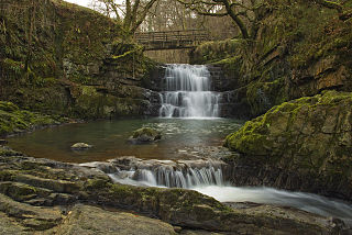
The Afon Sychryd is a river in Rhondda Cynon Taf, Wales. Although it is a relatively short river, with a total length of 3 miles (5 km), it is notable for the gorge and two waterfalls through which it flows.
