
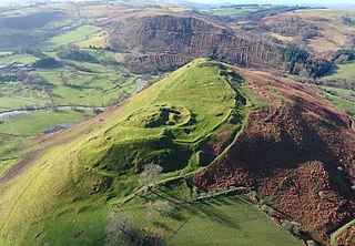
Castell Dinas is a hillfort and castle in southern Powys, Wales. At 450 m (1,476 feet) (SO179301) it has the highest castle in England and Wales. [1] It is positioned to defend the Rhiangoll pass between Talgarth and Crickhowell.
Castell Dinas is a hillfort and castle in southern Powys, Wales. At 450 m (1,476 feet) (SO179301) it has the highest castle in England and Wales. [1] It is positioned to defend the Rhiangoll pass between Talgarth and Crickhowell.
This site was originally an Iron Age, 600 BC to 50 AD, hillfort. A fortified Norman castle with stone walls was built on the site possibly by William Fitz Osbern or his son Roger de Breteuil, Earl of Hereford in the period 1070 to 1075. The castle was eclipsed with the building of Brecon castle before April 1093. The fortress seems to have been constructed in stone from the first with a hall-keep surrounded with curtain walls and square towers. Historically the castle remained a part of Brecon or Brycheiniog barony until 1207 when King John of England granted it to Peter FitzHerbert. It then became caput of what was to become the Talgarth or Blaenllyfni barony.
The castle was sacked by Prince Llywelyn ab Iorwerth in October 1233 and subsequently refortified by King Henry III of England before being returned to Peter Fitz Herbert. The castle was again captured by Llywelyn's grandson, Prince Llywelyn ap Gruffudd in the period 1263 to 1268. The castle was finally destroyed by the adherents of Owain Glyndŵr in the early 15th century rebellion.
What remains now are crumbling walls mainly covered with earth and the outlines of ditches and ramparts from the original Iron Age fortifications, commanding extensive views up into the Black Mountains and over Talgarth towards Brecon. Part of the 2m thick eastern wall of the bailey survives as a modern boundary wall. The only extant building is section of a gatehouse next to a postern gate at the northern end of the outer ward. [2]

A hillfort is a type of earthwork used as a fortified refuge or defended settlement, located to exploit a rise in elevation for defensive advantage. They are typically European and of the Bronze Age or Iron Age. Some were used in the post-Roman period. The fortification usually follows the contours of a hill and consists of one or more lines of earthworks, with stockades or defensive walls, and external ditches. If enemies were approaching, the civilians would spot them from a mile away.

William de Braose,, 4th Lord of Bramber, court favourite of King John of England, at the peak of his power, was also Lord of Gower, Abergavenny, Brecknock, Builth, Radnor, Kington, Limerick, Glamorgan, Skenfrith, Briouze in Normandy, Grosmont and White Castle.
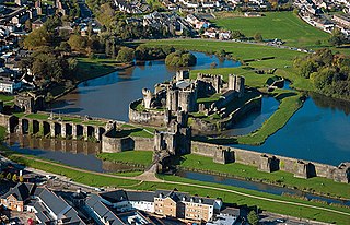
Caerphilly Castle is a medieval fortification in Caerphilly in South Wales. The castle was constructed by Gilbert de Clare in the 13th century as part of his campaign to maintain control of Glamorgan, and saw extensive fighting between Gilbert, his descendants, and the native Welsh rulers. Surrounded by extensive artificial lakes – considered by historian Allen Brown to be "the most elaborate water defences in all Britain" – it occupies around 30 acres (12 ha) and is the largest castle in Wales and the second-largest castle in the United Kingdom after Windsor Castle. It is famous for having introduced concentric castle defences to Britain and for its large gatehouses. Gilbert began work on the castle in 1268 following his occupation of the north of Glamorgan, with the majority of the construction occurring over the next three years at a considerable cost. The project was opposed by Gilbert's Welsh rival Llywelyn ap Gruffudd, leading to the site being burnt in 1270 and taken over by royal officials in 1271. Despite these interruptions, Gilbert successfully completed the castle and took control of the region. The core of Caerphilly Castle, including the castle's luxurious accommodation, was built on what became a central island, surrounding by several artificial lakes, a design Gilbert probably derived from that at Kenilworth. The dams for these lakes were further fortified, and an island to the west provided additional protection. The concentric rings of walls inspired Edward I's castles in North Wales, and proved what historian Norman Pounds has termed "a turning point in the history of the castle in Britain".

Talgarth is a market town, community and electoral ward in southern Powys, Mid Wales, about 12 miles (19 km) north of Crickhowell, 19 miles (31 km) north-east of Brecon and 15 miles (24 km) south-east of Builth Wells. Notable buildings in the town include the 14th-century parish church and a defensive tower house. According to traditional accounts, Talgarth was the capital of the early medieval kingdom of Brycheiniog. It is in the historic county of Brecknockshire. In 2011, it had a population of 1,724.

The Black Mountains are a group of hills spread across parts of Powys and Monmouthshire in southeast Wales, and extending across the England–Wales border into Herefordshire. They are the easternmost of the four ranges of hills that comprise the Brecon Beacons National Park, and are frequently confused with the westernmost, which is known as the Black Mountain. The Black Mountains may be roughly defined as those hills contained within a triangle defined by the towns of Abergavenny in the southeast, Hay-on-Wye in the north and the village of Llangors in the west. Other gateway towns to the Black Mountains include Talgarth and Crickhowell. The range of hills is well known to walkers and ramblers for the ease of access and views from the many ridge trails, such as that on the Black Hill in Herefordshire, at the eastern edge of the massif. The range includes the highest public road in Wales at Gospel Pass, and the highest point in southern England at Black Mountain.

Dolbadarn Castle is a fortification built by the Welsh prince Llywelyn the Great during the early 13th century, at the base of the Llanberis Pass, in northern Wales. The castle was important both militarily and as a symbol of Llywelyn's power and authority. The castle features a large stone keep, which historian Richard Avent considers "the finest surviving example of a Welsh round tower". In 1284 Dolbadarn was taken by Edward I, who removed some of its timbers to build his new castle at Caernarfon. The castle was used as a manor house for some years, before falling into ruin. In the 18th and 19th centuries, it was a popular destination for painters interested in Sublime and Picturesque landscapes. It is now owned by Cadw and managed as a tourist attraction, and is protected as a grade I listed building.

Castell Dinas Brân is a medieval castle, built by the Princes of Powys Fadog, which occupies a prominent hilltop site above the town of Llangollen in Denbighshire, Wales. The presently visible stone castle was probably built in the 1260s by Gruffydd Maelor II, a prince of Powys Fadog, on the site of several earlier structures, including an Iron Age hillfort.

Miles FitzWalter of Gloucester, 1st Earl of Hereford was a great magnate based in the west of England. He was hereditary Constable of England and Sheriff of Gloucestershire.
Cefnllys Castle was a medieval spur castle in Radnorshire, Wales. Two successive masonry castles were built on a ridge above the River Ithon known as Castle Bank in the thirteenth century, replacing a wooden motte-and-bailey castle constructed by the Normans nearby. Controlling several communication routes into the highlands of Mid Wales, the castles were strategically important within the Welsh Marches during the High Middle Ages. As the seat of the fiercely contested lordship and cantref of Maelienydd, Cefnllys became a source of friction between Llywelyn ap Gruffudd and Roger Mortimer in the prelude to Edward I's conquest of Wales (1277–1283). Cefnllys was also the site of a borough and medieval town.

Castell y Bere is a Welsh castle near Llanfihangel-y-pennant in Gwynedd, Wales. Constructed by Llywelyn the Great in the 1220s, the stone castle was intended to maintain his authority over the local people and to defend the south-west part of the princedom of Gwynedd. In 1282, war with Edward I of England resulted in the death of Llywelyn's grandson, Llywelyn ap Gruffudd, and Castell y Bere fell to English forces. Edward I expanded the castle further and established a small town beside it. In 1294 the Welsh leader Madog ap Llywelyn mounted a major revolt and the castle was besieged and apparently burnt. Edward did not repair it and it became ruined. Today it is in the hands of Cadw and operated as a tourist attraction.

Dolforwyn Castle is a Welsh medieval castle above the village of Abermule, Powys. The fortification was established by Llywelyn ap Gruffudd, Prince of Gwynedd in the late 13th century. It is sited on a wooded ridge commanding excellent views of the upper Severn Valley.
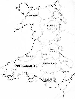
Brycheiniog was an independent kingdom in South Wales in the Early Middle Ages. It allied with the Mercian kingdom in the post Roman era, to stabilise and control a central (Marches) area key to dominance over central Proto-England to the east and the south Welsh kingdom of Deheubarth to the west. It was conquered and pacified by the Armorican Normans between 1088 and 1095, though it remained Welsh in character. It was transformed into the Lordship of Brecknock and later formed the southern and larger part of the historic county of Brecknockshire. To its south was the Kingdom of Morgannwg.

Llandovery Castle is a late thirteenth-century, Grade II*-listed, castle ruin in the town of Llandovery in Carmarthenshire, Wales. It occupies a knoll overlooking the River Towy and the land surrounding it. The Normans built a castle in the current location in the early twelfth century and this was rebuilt in stone. It was burnt in the early sixteenth century and never repaired.
Bernard de Neufmarché, also Bernard of Newmarket or Bernard of Newmarch was the first of the Norman conquerors of Wales. He was a minor Norman lord who rose to power in the Welsh Marches before successfully undertaking the invasion and conquest of the Kingdom of Brycheiniog between 1088 and 1095. Out of the ruins of the Welsh kingdom he created the Anglo-Norman lordship of Brecon.
This article is about the particular significance of the century 1201–1300 to Wales and its people.

Blaenllynfi Castle is a privately owned ruinous stone castle near the village of Bwlch in southern Powys, Wales. It was probably built in the early thirteenth century. It was captured several times during the rest of the century and apparently was never fully repaired afterwards and fell into ruins. It is a Scheduled Ancient Monument.
Castell Du, also known as Sennybridge Castle or Castell Rhyd-y-Briw, is located approximately eight miles west of Brecon in Powys, Wales, and is believed to be the work of Llywelyn ap Gruffudd, Prince of Wales. Its history is largely obscure, but a reference to a castle at Rhyd-y-Briw in a document of 1271 is believed to refer to the fortification, and it is not unreasonable to assume that work commenced on it during Llywelyn's triumphal years in the 1260s. Its life would seem to have been short, as there is no further reference to it in thirteenth-century documents, and it seems likely that it was captured by the forces of Edward I of England during the war of 1276–77 and subsequently abandoned. Much of the site remains to be excavated; the remains of a D-shaped tower are visible, and two other towers may lie under pill-boxes erected during the Second World War.
Sibyl de Neufmarché, Countess of Hereford, suo jure Lady of Brecknock, was a Cambro-Norman noblewoman, heiress to one of the most substantial fiefs in the Welsh Marches. The great-granddaughter of Gruffydd ap Llywelyn, king of Wales, Sibyl was also connected to the nobility of England and Normandy. Sibyl inherited the titles and lands of her father, Bernard de Neufmarché, Lord of Brecon, after her mother, Nest ferch Osbern, had declared her brother Mahel to have been illegitimate. Most of these estates passed to Sibyl's husband, Miles de Gloucester, 1st Earl of Hereford, as her dowry. Their marriage had been arranged personally by King Henry I of England in the spring of 1121. Sibyl, with her extensive lands, was central to the King's plans of consolidating Anglo-Norman power in south-east Wales by the merging of her estates with those of Miles, his loyal subject on whom he relied to implement Crown policy.
The Lordship of Brecknock was an Anglo-Norman marcher lordship located in southern central Wales.

Peter FitzHerbert, also known as Piers FitzHerbert, Lord of Blenlevenny, was a 13th-century nobleman and Sheriff of Yorkshire. FitzHerbert was one of the Counsellors named in Magna Carta in 1215. He was the son of Herbert FitzHerbert and Lucy of Hereford.
51°57′49″N3°11′47″W / 51.96355°N 3.196527°W
| Authority control databases: National |
|---|
