
Powys is a county and preserved county in Wales. It borders Gwynedd, Denbighshire, and Wrexham to the north; the English ceremonial counties of Shropshire and Herefordshire to the east; Monmouthshire, Blaenau Gwent, Merthyr Tydfil, Caerphilly, Rhondda Cynon Taf, and Neath Port Talbot to the south; and Carmarthenshire and Ceredigion to the west. The largest settlement is Newtown, and the administrative centre is Llandrindod Wells.

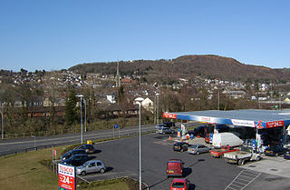
Ystradgynlais is a town on the River Tawe in southwest Powys, Wales. It is the second-largest town in Powys and is in the historic county of Brecknockshire. The town has a high proportion of Welsh language-speakers. The community includes Cwmtwrch, Abercraf and Cwmgiedd, with a population of 8,092 in the 2011 census. It forms part of the Swansea Urban Area where the Ystradgynlais subdivision has a population of 10,248.
Pontardawe is a town and a community in the Swansea Valley in Wales. Pontardawe also has a primary school within it, or “Ysgol Gynradd Gymraeg Pontardawe (YGGP). It is often named by its students and staff “pointy”. With a population of 6,832 in 2011, it comprises the electoral wards of Pontardawe and Trebanos. A town council is elected. Pontardawe forms part of the county borough of Neath Port Talbot. On the opposite bank of the River Tawe, the village of Alltwen, part of the community of Cilybebyll, is administered separately from Pontardawe. Pontardawe is at the crossroads of the A474 road and the A4067 road. Pontardawe came into existence as a small settlement on the northwestern bank of the Tawe where the drovers' road from Neath and Llandeilo crossed the river to go up the valley to Brecon.

Cwmtwrch is a village in the valley of the Afon Twrch, a right-bank tributary to the Swansea Valley, Wales, some 15 miles north of Swansea. It is also the name of an electoral ward to Powys County Council.

Bwlch is a small village and an electoral ward in the community of Cwmdu and District, Powys, south Wales. The settlement is strung out along the A40 road which crosses a low col above the Usk Valley at this point on its route between Brecon and Crickhowell.

The River Tawe is a 30 miles (48 km) long river in South Wales. Its headwaters flow initially east from its source below Llyn y Fan Fawr south of Moel Feity in the Black Mountains, the westernmost range of the Brecon Beacons National Park, before the river turns south and then southwest to its estuary at Swansea. Its main tributaries are the right bank Upper and Lower Clydach Rivers and the Afon Twrch. The total area of the catchment is some 246 km2 (95 sq mi). The Tawe passes through a number of towns and villages including Ystradgynlais, Ystalyfera, Pontardawe, and Clydach and meets the sea at Swansea Bay below Swansea. The Tawe Valley is more commonly known as the Swansea Valley.

Henrhyd Falls in the Brecon Beacons National Park, Wales, is the tallest waterfall in southern Wales with a drop of 90 feet (27 m). It lies on National Trust land, in the traditional county of Brecknockshire. The nearest settlement to it is Coelbren, on the road between Glynneath and Abercraf. Though not in the core of the area, it is considered by many to constitute a part of Wales' celebrated Waterfall Country.

Abercrâf or Abercrave is a village in Powys, Wales, in the community of Ystradgynlais and within the historic boundaries of the county of Brecknockshire.

The Diocese of Swansea and Brecon was established as a Diocese of the Church in Wales in 1923 with Brecon Priory as the cathedral. The area of the diocese had formerly been the Archdeaconry of Brecon within the Diocese of St Davids. The diocese has a border with each of the other five Welsh dioceses, as well as with the English Diocese of Hereford.
The Swansea Valley is one of the South Wales Valleys. It is the valley from the Brecon Beacons National Park to the sea at Swansea of the River Tawe in Wales. Administration of the area is divided between the City and County of Swansea, Neath Port Talbot County Borough, and Powys. A distinction may be drawn between the Lower Swansea valley and the Upper Swansea valley; the former was more heavily industrialised during the 19th and 20th centuries.

Penwyllt is a hamlet located in the upper Swansea Valley in Powys, Wales, lying within the Brecon Beacons National Park.

Caehopkin is a village in Powys, Wales. It lies between Abercraf and Coelbren in the Swansea Valley on the border of the Brecon Beacons National Park.

Fforest Fawr is an extensive upland area in the county of Powys, Wales. Formerly known as the Great Forest of Brecknock in English, it was a royal hunting area for several centuries but is now used primarily for sheep grazing, forestry, water catchment and recreation. It lies within the Brecon Beacons National Park.
The Brecon Forest Tramroad is an early nineteenth century tramroad, or rather a network of connecting tramroads or waggonways, which stretched across the hills of Fforest Fawr in the historic county of Brecknockshire in south Wales, UK. Its northern terminus was at the village of Sennybridge in the Usk Valley whilst its southern ends lay at Abercraf and Ystradgynlais in the upper Swansea Valley some 20 km to the south.

Tawe-Uchaf is a community in Powys, Wales. Situated north-east of Ystradgynlais in the upper valley of the River Tawe, it includes the villages of Caehopkin, Coelbren, Glyntawe, Pen-y-cae, Penwyllt and Ynyswen. It had a population in 2001 of 1,516, increasing at the 2011 Census to 1,562.
Trallong is a village and community in Powys, Wales, in the historic county of Brecknockshire.

Colbren Junction was a railway station on the Neath and Brecon Railway. The station, which was near Coelbren, was completed at the same time as the Swansea Vale and Neath and Brecon Joint Railway opened a seven-mile branch from here to Ynysygeinon in 1873. It was a key junction in the networks operated by the Midland, Neath and Brecon, and Great Western railway companies.

Mynydd y Drum is a hill on the border between the county of Powys and Neath Port Talbot County Borough, south Wales. The summit of the hill is in Neath Port Talbot at 298m and lies towards the western end of a broad curving ridge, the larger part of which is in Powys. The eastern half of the hill is currently being opencasted for coal. The hill is sometimes referred to simply as The Drum.

Penderyn is a rural village in the Cynon Valley, Rhondda Cynon Taf, Wales, located near Hirwaun.

Thomas Thomas was a Welsh church minister and chapel architect, also known as Thomas Glandŵr. He is described as "the first national architect of Wales" and the "unchallenged master of chapel architecture in Wales in the 1860s".


