Ajax Peak

Last updated
Ajax Peak
Ajax Pk Telluride.jpg
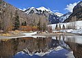
West aspect, from Telluride
Highest point
Elevation 12,785 ft (3,897 m) [1]
Prominence 105 ft (32 m) [1]
Parent peak Chicago Peak (13,385 ft) [2]
Isolation 1.16 mi (1.87 km) [2]
Coordinates 37°55′43″N107°45′20″W / 37.9285995°N 107.7556066°W / 37.9285995; -107.7556066 [3]
Naming
Etymology Ajax the Great [4]
Geography
USA Colorado relief location map.svg
Red triangle with thick white border.svg
Ajax Peak
Location in Colorado
Usa edcp relief location map.png
Red triangle with thick white border.svg
Ajax Peak
Ajax Peak (the United States)
Location San Miguel County
Colorado, US
Parent range Rocky Mountains
San Juan Mountains
Topo map USGS Telluride
Climbing
Easiest route Hiking trail [5]

Ajax Peak is a 12,785-foot-elevation (3,897-meter) mountain summit located in San Miguel County of southwest Colorado, United States. [3] It is situated on land managed by Uncompahgre National Forest, and is the iconic landmark visible three miles east of the community of Telluride. Ajax is set immediately south of Savage Basin and the ghost town of Tomboy, one mile southwest of Chicago Peak, and one mile west of Telluride Peak. It is also immediately northeast of Bridal Veil Falls, Colorado's highest waterfall at 365-feet high. [6] It is part of the San Juan Mountains which are a subset of the Rocky Mountains. Topographic relief is significant as the west aspect rises 3,800 feet (1,200 meters) above the box canyon in approximately one mile. The old mill town of Pandora at the base of Ajax Peak was hit by snow slides each winter, and one particularly bad event in 1884 came over the Ajax Mine and wrecked the mills. [7]

Contents

Climate

According to the Köppen climate classification system, Ajax Peak has an alpine subarctic climate with cold, snowy winters, and cool to warm summers. [8] Due to its altitude, it receives precipitation all year, as snow in winter, and as thunderstorms in summer, with a dry period in late spring. Precipitation runoff from the mountain drains into tributaries and headwaters of the San Miguel River.

See also

Related Research Articles

<span class="mw-page-title-main">Sharkstooth Peak</span>

Sharkstooth Peak is a 12,468-foot-elevation (3,800-meter) mountain summit in Montezuma County, Colorado.

<span class="mw-page-title-main">Dallas Peak</span> Mountain in the state of Colorado

Dallas Peak is a high mountain summit in the Sneffels Range of the Rocky Mountains of North America. The 13,815-foot (4,211 m) thirteener is located in the Mount Sneffels Wilderness of Uncompahgre National Forest, 3.3 miles (5.3 km) north by west of the Town of Telluride, Colorado, United States, on the drainage divide between Ouray and San Miguel counties.

<span class="mw-page-title-main">Gladstone Peak</span> Mountain in the state of Colorado

Gladstone Peak is a high mountain summit in the San Miguel Mountains range of the Rocky Mountains of North America. The 13,919-foot (4,243 m) thirteener is located in the Lizard Head Wilderness, 11.2 miles (18.0 km) southwest by west of the Town of Telluride, Colorado, United States, on the drainage divide separating San Juan National Forest and Dolores County from Uncompahgre National Forest and San Miguel County. The mountain was named in honor of British Prime Minister William Gladstone.

<span class="mw-page-title-main">Gilpin Peak</span> Mountain in the state of Colorado

Gilpin Peak is a high mountain summit in the Sneffels Range of the Rocky Mountains of North America. The 13,700-foot (4,176 m) thirteener is located in the Mount Sneffels Wilderness of Uncompahgre National Forest, 3.5 miles (5.6 km) north-northeast of the Town of Telluride, Colorado, United States, on the drainage divide between Ouray County and San Miguel County. Gilpin Peak was named in honor of William Gilpin, the first Governor of the Territory of Colorado.

<span class="mw-page-title-main">Snowdon Peak</span> Mountain in Colorado, United States

Snowdon Peak is a 13,077-foot-elevation (3,986-meter) mountain summit located in San Juan County, Colorado, United States. It is situated seven miles south of the community of Silverton, in the Weminuche Wilderness, on land managed by San Juan National Forest. It is part of the San Juan Mountains range which is a subset of the Rocky Mountains of North America, and is set nine miles west of the Continental Divide. Topographic relief is significant as the east aspect rises 4,300 feet above the Animas River in approximately 1.5 mile. Neighbors include Mount Garfield three miles to the east-southeast, and Twilight Peak, which is the nearest higher peak, 3.7 miles to the south-southwest. This mountain can be seen from U.S. Route 550. The mountain is named after Snowdon, the highest mountain in Wales.

<span class="mw-page-title-main">Mears Peak</span> Mountain in the state of Colorado

Mears Peak is a 13,496-foot-elevation (4,114-meter) mountain summit located on the common boundary of Ouray County with San Miguel County, in Colorado, United States. It is situated six miles northwest of the community of Telluride, in the Mount Sneffels Wilderness, on land managed by Uncompahgre National Forest. It is part of the Sneffels Range which is a subset of the San Juan Mountains, which in turn is part of the Rocky Mountains. Mears Peak is situated west of the Continental Divide, and 3.8 miles west of Mount Sneffels. Topographic relief is significant as the south aspect rises 4,900 feet above the San Miguel River in approximately 5.5 miles.

<span class="mw-page-title-main">Hayden Peak (San Miguel County, Colorado)</span> Mountain in the state of Colorado

Hayden Peak is a 12,987-foot-elevation (3,958-meter) mountain summit located in San Miguel County, in Colorado, United States. It is situated nine miles northwest of the community of Telluride, in the Mount Sneffels Wilderness, on land managed by Uncompahgre National Forest. It is part of the Sneffels Range which is a subset of the San Juan Mountains, which in turn is part of the Rocky Mountains. Hayden Peak is situated west of the Continental Divide, and three miles northwest of Mears Peak. Topographic relief is significant as the south aspect rises 2,000 feet above Deep Creek in approximately one mile.

<span class="mw-page-title-main">Sunshine Mountain</span> Mountain in the state of Colorado

Sunshine Mountain is a 12,930-foot-elevation (3,940-meter) mountain summit located in San Miguel County, in Colorado, United States. It is situated nine miles southwest of the community of Telluride, in the Lizard Head Wilderness, on land managed by Uncompahgre National Forest. It is part of the San Juan Mountains which is a subset of the Rocky Mountains. Sunshine Mountain is situated 24 miles west of the Continental Divide, 2.75 miles east of Wilson Peak, and 1.8 mile northeast of Lizard Head, the nearest higher neighbor. Topographic relief is significant as the west aspect rises 2,700 feet above Bilk Creek in approximately one mile. The mountain is composed of rock of the San Juan Formation overlaying Telluride Conglomerate, in turn overlaying Mancos Shale. The mountain's name, which has been officially adopted by the United States Board on Geographic Names, was in use before 1899 when Henry Gannett published it in A Dictionary of Altitudes in the United States.

<span class="mw-page-title-main">Mount Emma</span> Mountain in the state of Colorado

Mount Emma is a 13,581-foot-elevation (4,139-meter) mountain summit located in San Miguel County of Colorado, United States. It is situated three miles north of the community of Telluride, on the south side of Yankee Boy Basin, in the Uncompahgre National Forest. It is part of the Sneffels Range which is a subset of the San Juan Mountains, which in turn is part of the Rocky Mountains. Mount Emma is situated west of the Continental Divide, two miles south of Mount Sneffels, and 0.8 mile south of Gilpin Peak, the nearest higher neighbor. Emma ranks as the 197th-highest peak in Colorado, and the 10th-highest in the Sneffels Range. Topographic relief is significant as the south aspect rises 4,830 feet above Telluride in approximately three miles. An ascent of Mt. Emma is a difficult climb with 2,180 feet of elevation gain covering three miles from Yankee Boy Basin, or 4,836 feet of elevation gain from Telluride. This mountain's name was officially adopted by the U.S. Board on Geographic Names.

<span class="mw-page-title-main">Engineer Mountain</span> Mountain in Colorado, United States

Engineer Mountain is a 12,968-foot-elevation (3,953-meter) mountain summit located in San Juan County, Colorado, United States. It is part of the San Juan Mountains range which is a subset of the Rocky Mountains, and is west of the Continental Divide. Engineer Mountain is a prominent landmark set 1.5 mile immediately west of Coal Bank Pass, and is visible from multiple viewpoints along Highway 550, making it one of the most photographed mountains in the San Juans. It is situated 11 miles southwest of the community of Silverton, on land managed by San Juan National Forest. Topographic relief is significant as the southwest aspect rises 3,800 feet above Cascade Creek in approximately two miles. Neighbors include Snowdon Peak seven miles to the east, and Twilight Peak, five miles to the southeast.

<span class="mw-page-title-main">Wasatch Mountain (Colorado)</span> Mountain in the American state of Colorado

Wasatch Mountain is a 13,555-foot (4,132 m) mountain in the San Miguel Mountains in San Miguel County, Colorado, United States.

<span class="mw-page-title-main">Golden Horn (Colorado)</span> Mountain summit in southwest Colorado

Golden Horn is a 13,780-foot-elevation (4,200-meter) mountain summit located on the shared boundary of San Juan County with San Miguel County, in southwest Colorado, United States. It is situated nine miles west of the community of Silverton, on land managed by San Juan National Forest and Uncompahgre National Forest. Golden Horn is part of the San Juan Mountains which are a subset of the Rocky Mountains, and is west of the Continental Divide. It ranks as the 116th-highest peak in Colorado, and topographic relief is significant as the west aspect rises 3,800 feet in approximately 1.5 mile. The mountain's name, which has been officially adopted by the United States Board on Geographic Names, was in use in 1906 when Henry Gannett published it in A Gazetteer of Colorado.

<span class="mw-page-title-main">Palmyra Peak</span> Mountain in the state of Colorado

Palmyra Peak is a 13,319-foot-elevation (4,060-meter) mountain summit located in San Miguel County of southwest Colorado, United States. It is situated four miles south of the town of Telluride, on land managed by Uncompahgre National Forest. It is part of the San Juan Mountains which are a subset of the Rocky Mountains, and is west of the Continental Divide. It is immediately south of Telluride Ski Resort, from which it is a prominent landmark, and Palmyra has the distinction of having the highest inbounds skiing terrain of any North American ski resort. Topographic relief is significant as the north aspect rises 2,300 feet above Prospect Basin in one mile, and the west aspect rises 2,100 feet above Alta Lakes in one-half mile. The mountain's name has been officially adopted by the United States Board on Geographic Names in association with the Palmyra Mine, a gold and silver mine located at an elevation of 11,650-feet on the peak's western aspect. Other mines on its flanks included Lakeview Mine, Mountain Quail Mine, Roy Johnston mine, and Turkey Creek Mine.

<span class="mw-page-title-main">Silver Mountain (San Miguel County, Colorado)</span> Mountain in the state of Colorado

Silver Mountain is a 13,470-foot-elevation (4,106 meter) mountain summit located in San Miguel County of southwest Colorado, United States. It is situated 4.5 miles south of the town of Telluride, on land managed by Uncompahgre National Forest. It is part of the San Juan Mountains which are a subset of the Rocky Mountains, and is west of the Continental Divide. Silver Mountain ranks as the 274th-highest peak in Colorado, and topographic relief is significant as the south aspect rises 3,770 feet above Ophir in 1.5 mile. The mountain's name has been officially adopted by the United States Board on Geographic Names in association with silver mines on the peak's flanks.

<span class="mw-page-title-main">Chicago Peak</span> Mountain in the state of Colorado

Chicago Peak is a 13,385-foot-elevation (4,080-meter) mountain summit located on the shared boundary of San Miguel County with Ouray County in southwest Colorado, United States. It is situated four miles (6.4 km) east of the community of Telluride, on land managed by Uncompahgre National Forest. It is part of the Sneffels Range which is a subset of the San Juan Mountains, which in turn are part of the Rocky Mountains. It is set above the ghost town of Tomboy, one mile (1.6 km) south of United States Mountain, and one mile northwest of Imogene Pass. Topographic relief is significant as the east aspect rises 2,000 feet above Imogene Basin in approximately one mile, and the west aspect rises 2,000 feet above Savage Basin in less than one mile. Mining activity in the immediate area produced significant amounts of gold and silver.

<span class="mw-page-title-main">Lookout Peak (Colorado)</span> Mountain in the state of Colorado

Lookout Peak is a 13,661-foot-elevation (4,164-meter) mountain summit located on the shared boundary of San Juan County with San Miguel County, in southwest Colorado, United States. It is situated three miles east of the community of Ophir, and one mile immediately north of Ophir Pass, on land managed by San Juan National Forest and Uncompahgre National Forest. Lookout Peak is part of the San Juan Mountains which are a subset of the Rocky Mountains, and is west of the Continental Divide. It ranks as the 166th-highest peak in Colorado, and topographic relief is significant as the west aspect rises 3,000 feet in approximately one mile. Neighbors include Silver Mountain three miles to the west-northwest, Wasatch Mountain two miles north-northwest, and Golden Horn five miles south-southwest. The mountain's name, which has been officially adopted by the United States Board on Geographic Names, was in use in 1899 when Henry Gannett published it in A Dictionary of Altitudes in the United States, and in 1906 when he published it in A Gazetteer of Colorado.

<span class="mw-page-title-main">Sheep Mountain (San Miguel and Dolores Counties, Colorado)</span>

Sheep Mountain is a 13,188-foot-elevation (4,020-meter) mountain summit located on the shared boundary of Dolores County with San Miguel County, in southwest Colorado, United States. It is situated three miles south of Trout Lake and two miles southeast of Lizard Head Pass, on land managed by San Juan National Forest and Uncompahgre National Forest. Sheep Mountain is part of the San Juan Mountains which are a subset of the Rocky Mountains, and is west of the Continental Divide. Topographic relief is significant as the southwest aspect rises 3,200 feet above the Dolores River in approximately 2.5 miles. Neighbors include Golden Horn and Vermilion Peak to the east, and Lizard Head to the northwest. Sheep Mountain can be seen from the San Juan Skyway in the Lizard Head Pass and Trout Lake areas. The mountain's name, which has been officially adopted by the United States Board on Geographic Names, was in use in 1906 when Henry Gannett published it in A Gazetteer of Colorado.

<span class="mw-page-title-main">Ulysses S Grant Peak</span> Mountain in the state of Colorado

Ulysses S Grant Peak is a 13,767-foot-elevation (4,196-meter) mountain summit located on the shared boundary of San Juan County with San Miguel County, in southwest Colorado, United States. It is situated eight miles west of the community of Silverton, on land managed by San Juan National Forest and Uncompahgre National Forest. Ulysses S Grant Peak is part of the San Juan Mountains which are a subset of the Rocky Mountains, and is west of the Continental Divide. It ranks as the 119th-highest peak in Colorado, and topographic relief is significant as the west aspect rises 2,400 feet in approximately one mile. The mountain's name, which has been officially adopted by the United States Board on Geographic Names, was in use in an 1896 scientific publication by Charles Whitman Cross, and listed by Henry Gannett when he published A Gazetteer of Colorado in 1906.

<span class="mw-page-title-main">Pilot Knob (Colorado)</span> Mountain summit in southwest Colorado

Pilot Knob is a 13,738-foot-elevation (4,187-meter) mountain summit located on the shared boundary of San Juan County with San Miguel County, in southwest Colorado, United States. It is situated nine miles west of the community of Silverton, on land managed by San Juan National Forest and Uncompahgre National Forest. Pilot Knob is part of the San Juan Mountains which are a subset of the Rocky Mountains, and is west of the Continental Divide. It ranks as the 132nd-highest peak in Colorado, and topographic relief is significant as the west aspect rises 4,000 feet above Trout Lake in three miles. Neighbors include Ulysses S Grant Peak 1.5 mile to the northeast, and Golden Horn one-half mile to the southeast. The mountain's name, which has been officially adopted by the United States Board on Geographic Names, was listed by Henry Gannett when he published A Gazetteer of Colorado in 1906. The peak is considered one of the most difficult to climb in Colorado because of its poor quality volcanic rock.

<span class="mw-page-title-main">Cross Mountain (Colorado)</span> Mountain in the state of Colorado

Cross Mountain is a 12,703-foot-elevation (3,872-meter) summit on the border shared by Dolores and San Miguel County, in Colorado, United States.

References

  1. 1 2 "Ajax Peak, Colorado". Peakbagger.com.
  2. 1 2 "Ajax Peak - 12,785' CO". listsofjohn.com. Retrieved 2021-07-14.
  3. 1 2 "Ajax Peak". Geographic Names Information System . United States Geological Survey, United States Department of the Interior . Retrieved 2021-07-14.
  4. William Bright, Colorado Place Names, 2004, Johnson Books, ISBN   9781555663339, page 3.
  5. Don Scarmuzzi, 2005, Telluride Trails, Pruett Publishing Company, ISBN   9780871089380, page 60.
  6. Hugh McNaughtan, Lonely Planet Western USA, 2018
  7. Caroline Bancroft, Unique Ghost Towns and Mountain Spots, 1961, Johnson Publishing Company, ISBN   9780933472242, page 92.
  8. Peel, M. C.; Finlayson, B. L.; McMahon, T. A. (2007). "Updated world map of the Köppen−Geiger climate classification". Hydrol. Earth Syst. Sci. 11. ISSN   1027-5606.