
The Bahamas, officialy the Commonwealth of The Bahamas, is a country within the Lucayan Archipelago of the West Indies in the Atlantic. It takes up 97% of the Lucayan Archipelago's land area and is home to 88% of the archipelago's population. The archipelagic state consists of more than 3000 [2] islands, cays, and islets in the Atlantic Ocean, and is located north of Cuba and northwest of the island of Hispaniola and the Turks and Caicos Islands, southeast of the American state of Florida, and east of the Florida Keys. The capital is Nassau on the island of New Providence. The Royal Bahamas Defence Force describes The Bahamas' territory as encompassing 470,000 km2 (180,000 sq mi) of ocean space.
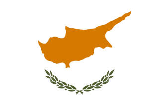
Cyprus, officially the Republic of Cyprus, is an island country in the eastern Mediterranean Sea south of the Anatolian Peninsula. It is the third-largest and third-most populous island in the Mediterranean, and is south of Turkey and west of Syria. Its capital and largest city is Nicosia.

The Canary Islands, also known informally as the Canaries, are a Spanish region and archipelago in the Atlantic Ocean, in Macaronesia. At their closest point to the African mainland, they are 100 kilometres west of Morocco. They are the southernmost of the autonomous communities of Spain. The islands have a population of 2.15 million people and they are one of the outermost regions of the European Union.

Hawaii is a state in the Western United States, located in the Pacific Ocean about 2,000 miles from the U.S. mainland. It is the only U.S. state outside North America, the only state that is an archipelago, and the only state in the tropics. Hawaii is also one of several U.S. states that were independent nations prior to joining the Union.

The Isle of Man, also known as Mann, is an island nation and self-governing British Crown Dependency in the Irish Sea between Great Britain and Ireland. The head of state, Queen Elizabeth II, holds the title Lord of Mann and is represented by a Lieutenant Governor. The United Kingdom is responsible for the isle's military defence.
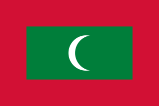
Maldives, officially the Republic of Maldives, is an archipelagic country located in the Indian subcontinent of Southern Asia, situated in the Indian Ocean. It lies southwest of Sri Lanka and India, about 750 kilometres from the Asian continent's mainland. The chain of 26 atolls stretches from Ihavandhippolhu Atoll in the north to Addu Atoll in the south.

Malta, officially known as the Republic of Malta, is an island country in the European Union consisting of an archipelago in the Mediterranean Sea, and considered part of Southern Europe. It lies 80 km (50 mi) south of Sicily (Italy), 284 km (176 mi) east of Tunisia, and 333 km (207 mi) north of Libya. The official languages are Maltese and English, and 66% of the current Maltese population is at least conversational in the Italian language.

The Marshall Islands, officially the Republic of the Marshall Islands, is an independent island country near the Equator in the Pacific Ocean, slightly west of the International Date Line. Geographically, the country is part of the larger island group of Micronesia. The country's population of 58,413 people is spread out over five islands and 29 coral atolls, comprising 1,156 individual islands and islets. The capital and largest city is Majuro. It has the largest portion of its territory composed of water of any sovereign state, at 97.87%. The islands share maritime boundaries with Wake Island to the north, Kiribati to the southeast, Nauru to the south, and Federated States of Micronesia to the west. About 52.3% of Marshall Islanders live on Majuro. In 2016, 73.3% of the population were defined as being "urban". The UN also indicates a population density of 760 inhabitants per square mile (295/km2), and its projected 2020 population is 59,190.

Mauritius, officially the Republic of Mauritius, is an island nation in the Indian Ocean about 2,000 kilometres (1,200 mi) off the southeast coast of the African continent, east of Madagascar. It includes the main island, as well as Rodrigues, Agaléga and St. Brandon. The islands of Mauritius and Rodrigues, along with nearby Réunion, are part of the Mascarene Islands. The capital and largest city, Port Louis, is located in Mauritius, where most of the population is concentrated. The country spans 2,040 square kilometres (790 sq mi) and has an exclusive economic zone covering 2.3 million square kilometres.

Oceania is a geographic region that includes Australasia, Melanesia, Micronesia and Polynesia. Spanning the Eastern and Western Hemispheres, Oceania is estimated to have a land area of 8,525,989 square kilometres (3,291,903 sq mi) and a population of over 41 million. When compared with the continents, the region of Oceania is the smallest in land area and the second smallest in population after Antarctica. Its five major population centres are Sydney, Melbourne, Brisbane, Perth, and Auckland.

The Pacific Ocean is the largest and deepest of Earth's five oceanic divisions. It extends from the Arctic Ocean in the north to the Southern Ocean in the south, and is bounded by the continents of Asia and Australia in the west and the Americas in the east.

Rhode Island, officially the State of Rhode Island, is a state in the New England region of the Northeastern United States. It is the smallest U.S. state by area and the seventh-least populous, with slightly fewer than 1.1 million residents as of 2020, but it is the second-most densely populated after New Jersey. It takes its name from the eponymous island, though most of its land area is on the mainland. Rhode Island borders Connecticut to the west, Massachusetts to the north and east, and the Atlantic Ocean to the south via Rhode Island Sound and Block Island Sound; it also shares a small maritime border with New York. Providence is its capital and most populous city.
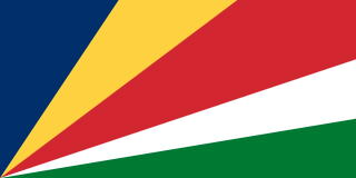
Seychelles, officially the Republic of Seychelles, is an archipelagic island country consisting of 115 islands in the Indian Ocean at the eastern edge of the Somali Sea. Its capital and largest city, Victoria, is 1,500 kilometres east of mainland Africa. Nearby island countries and territories include the Comoros, Madagascar, Mauritius, and the French overseas regions of Mayotte and Réunion to the south; and Maldives and the Chagos Archipelago to the east. It is the least populous sovereign African country, with an estimated 2020 population of 98,462.

Solomon Islands is a sovereign country consisting of six major islands and over 900 smaller islands in Oceania, to the east of Papua New Guinea and northwest of Vanuatu. It has a land area of 28,400 square kilometres (11,000 sq mi), and a population of 652,858. Its capital, Honiara, is located on the largest island, Guadalcanal. The country takes its name from the Solomon Islands archipelago, which is a collection of Melanesian islands that also includes the North Solomon Islands, but excludes outlying islands, such as the Santa Cruz Islands and Rennell and Bellona.

New Zealand is an island country in the southwestern Pacific Ocean. It consists of two main landmasses—the North Island and the South Island —and over 700 smaller islands. It is the sixth-largest island country by area, covering 268,021 square kilometres (103,500 sq mi). New Zealand is about 2,000 kilometres (1,200 mi) east of Australia across the Tasman Sea and 1,000 kilometres (600 mi) south of the islands of New Caledonia, Fiji, and Tonga. The country's varied topography and sharp mountain peaks, including the Southern Alps, owe much to tectonic uplift and volcanic eruptions. New Zealand's capital city is Wellington, and its most populous city is Auckland.

The Falkland Islands are an archipelago in the South Atlantic Ocean on the Patagonian Shelf. The principal islands are about 300 miles east of South America's southern Patagonian coast and about 752 miles from the northern tip of the Antarctic Peninsula, at a latitude of about 52°S. The archipelago, with an area of 4,700 square miles, comprises East Falkland, West Falkland, and 776 smaller islands. As a British overseas territory, the Falklands have internal self-governance, and the United Kingdom takes responsibility for their defence and foreign affairs. The capital and largest settlement is Stanley on East Falkland.

Great Britain is an island in the North Atlantic Ocean off the north-west coast of continental Europe. With an area of 209,331 km2 (80,823 sq mi), it is the largest of the British Isles, the largest European island and the ninth-largest island in the world. The island is dominated by a maritime climate with narrow temperature differences between seasons. The 60% smaller island of Ireland is to the west – together these islands, along with over 1,000 smaller surrounding islands and named substantial rocks, form the British Isles archipelago.

The Faroe Islands, or simply the Faroes or Faeroes, are a North Atlantic archipelago and island country located 320 kilometres (200 mi) north-northwest of Scotland, and about halfway between Norway and Iceland. Like Greenland, it is a constituent country of the Kingdom of Denmark. The islands have a total area of about 1,400 square kilometres (540 sq mi) with a population of 53,882 as of April 2022.
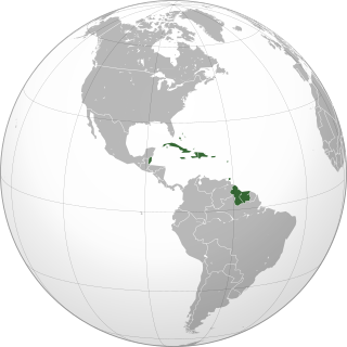
The Caribbean is a region of the Americas that consists of the Caribbean Sea, its islands and the surrounding coasts. The region is southeast of the Gulf of Mexico and the North American mainland, east of Central America, and north of South America.

