
Baffin Island, in the Canadian territory of Nunavut, is the largest island in Canada and the fifth-largest island in the world. Its area is 507,451 km2 (195,928 sq mi)—slightly larger than Spain, its population was 13,039 as of the 2021 Canadian census, and is located at 68°N70°W. It also contains the city of Iqaluit, the capital of Nunavut.
Prince Charles Island is a large, low-lying island with an area of 9,521 km2 (3,676 sq mi), making it the world's 77th largest island and the 19th largest island in Canada. It is located in Foxe Basin, off the west coast of Baffin Island, in the Qikiqtaaluk Region of Nunavut, Canada. Despite the island's size, it was not discovered until 1932, when the tug captain W. A. Poole first sighted it. His information never made it onto any published map. It was rediscovered in 1948 by Albert-Ernest Tomkinson navigating an Avro Lancaster for the RCAF 408 (Photo) Squadron, though it was likely known to the local Inuit long before that. The island was named for British Prince Charles, who was born in November the same year. The island is uninhabited and its temperatures are extremely cold.

Southampton Island is a large island at the entrance to Hudson Bay at Foxe Basin. One of the larger members of the Arctic Archipelago, Southampton Island is part of the Kivalliq Region in Nunavut, Canada. The area of the island is stated as 41,214 km2 (15,913 sq mi) by Statistics Canada. It is the 34th largest island in the world and Canada's ninth largest island. The only settlement on Southampton Island is Coral Harbour, called Salliq in Inuktitut.

Melville Peninsula is a large peninsula in the Canadian Arctic north of Hudson Bay. It is named after American explorer George Melville (1841-1912). To the east is Foxe Basin and to the west the Gulf of Boothia. To the north the Fury and Hecla Strait separates it from Baffin Island. To the south Repulse Bay and Frozen Strait separate it from Southampton Island at the north end of Hudson Bay. On the southwest it is connected to the mainland by the Rae Isthmus, named after the Arctic explorer John Rae.

Russell Island is an uninhabited island of the Arctic Archipelago in the Qikiqtaaluk Region of Nunavut, Canada. It is located in the Parry Channel, separated from the northern tip of Prince of Wales Island by the narrow Baring Channel. The western third of the island is separated from the other two thirds by a narrow lake and its outlet. At the northern end of the lake there is an isthmus just 1.1 km (0.68 mi) wide and this joins the two parts of the island. With a total area of 940 km2 (360 sq mi), it is the largest island offshore of Prince of Wales Island.

Qikiqtaaluk (ᕿᑭᖅᑖᓗᒃ), formerly White Island, is one of the uninhabited Canadian arctic islands in the Kivalliq Region, Nunavut, Canada. Located in Foxe Basin off the northern tip of Southampton Island, it measures 789 km2 (305 sq mi) in area.
Foxe Basin is a shallow oceanic basin north of Hudson Bay, in Nunavut, Canada, located between Baffin Island and the Melville Peninsula. For most of the year, it is blocked by sea ice and drift ice made up of multiple ice floes.

Luke Foxe was an English explorer, born in Kingston-upon-Hull, Yorkshire, who searched for the Northwest Passage across North America. In 1631, he sailed much of the western Hudson Bay before concluding no such passage was possible. Foxe Basin, Foxe Channel and Foxe Peninsula were named after him.
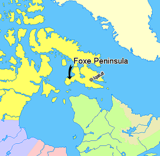
Foxe Peninsula is a peninsula found at the southern end of Baffin Island in the Qikiqtaaluk Region of Nunavut, Canada. It juts out from the southerly end of the island in a southwestly direction, dividing Foxe Basin and Hudson Strait. Its western extremity is Cape Queen; to the southeast lies the Inuit hamlet of Cape Dorset. Inuksuk Point at the western coast contains more than 100 inuksuit.
The Ottawa Islands are a group of currently uninhabited islands situated in the eastern edge of Canada's Hudson Bay. The group comprises 24 small islands, located at approximately 60N 80W. The main islands include Booth Island, Bronson Island, Eddy Island, Gilmour Island, J. Gordon Island, Pattee Island, and Perley Island. The highest point is on Gilmour Island, which rises to over 1,800 ft (550 m). Located a short distance off the northwest coast of Quebec's Ungava Peninsula, they, like the other coastal islands in Hudson Bay, were historically part of the Northwest Territories, and became Crown Land upon the creation of Nunavut in 1999. Nunavik Inuit have occupied these islands since time immemorial and gained constitutionally-protected harvest and access rights under the Nunavik Inuit Land Claim Agreement signed in 2007.
South Tweedsmuir Island is one of the Canadian arctic islands located in Foxe Basin, off the southwest coast of Baffin Island, in the Qikiqtaaluk Region of Nunavut, Canada. Foley Island is to the north, North Tweedsmuir Island is to the northwest, Prince Charles Island is to the west, and Air Force Island is to the south.
The Spicer Islands are an uninhabited island group located in Foxe Basin, within Qikiqtaaluk Region, in the Canadian territory of Nunavut. The Melville Peninsula is to the west, Prince Charles Island to the east, Rowley Island to the north. The two main islands are North Spicer Island and South Spicer Island. They are very low-lying and swampy.
Piling Bay is an uninhabited waterway in the Qikiqtaaluk Region, Nunavut, Canada. It is located on the west central coast of Baffin Island. An arm of the Foxe Basin, it contains many small, unnamed islands. Foley Island and North Tweedsmuir Island lie outside the mouth of the bay to the south/southwest.
Dunne Foxe Island is one of the Canadian arctic islands in Nunavut, Canada within western Hudson Bay. The hamlet of Whale Cove is 25 km (16 mi) to the west.
The Foxe Channel is an area of sea in Qikiqtaaluk Region, Nunavut, Canada. It separates the Foxe Basin from Hudson Bay and the Hudson Strait. To the west and south-west is Southampton Island, to the east is Baffin Island, and to the north-west is the Melville Peninsula.
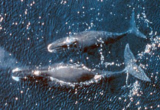
The bowhead whale is a species of baleen whale belonging to the family Balaenidae and the only living representative of the genus Balaena. They are the only baleen whale endemic to the Arctic and subarctic waters, and are named after their characteristic massive triangular skull, which they use to break through Arctic ice. Other common names of the species are the Greenland right whale or Arctic whale. American whalemen called them the steeple-top, polar whale, or Russia or Russian whale.

Dorset Island or Cape Dorset Island is one of the Canadian Arctic islands located in Hudson Strait, Nunavut, Canada. It lies off the Foxe Peninsula area of southwestern Baffin Island in the Qikiqtaaluk Region. It is serviced by an airport and a harbour.
Thomas Henry Manning, OC was a British-Canadian Arctic explorer, biologist, geographer, zoologist, and author. Appointed an Officer of the Order of Canada, Manning held the positions of vice-chairman and Executive Director of the Arctic Institute of North America. Nicknamed the Lone Wolf of the Arctic, he was known for travelling alone with dog sled and canoe.
Gibson Bay is an arm of the Foxe Basin in the Qikiqtaaluk Region of Nunavut, Canada. It is located on the northern coast of Foxe Peninsula, in western Baffin Island. The closest community is Cape Dorset, situated 123 km (76 mi) to the south, while Nuwata, a former settlement, is situated to the west. It is fed by the Kommanik River whose headwaters are at Kavivan Lake, 5 mi (8.0 km) to the southeast. Within the bay, there is a small island chain.

