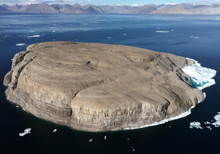
Hans Island is a barren uninhabited island with an area of 1.3 km2 (0.50 sq mi), measuring 1,290 by 1,199 m, in the centre of the Kennedy Channel of Nares Strait—the strait that separates Ellesmere Island from northern Greenland and connects Baffin Bay with the Lincoln Sea. Hans Island is the smallest of three islands in Kennedy Channel off the Washington Land coast; the others are Franklin Island and Crozier Island. The strait at this point is 35 km (22 mi) wide, placing the island within the territorial waters of both Canada and Greenland (Denmark). A theoretical line in the middle of the strait goes through the island.
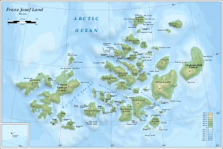
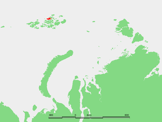
Franz Josef Land, Frantz Iosef Land, Franz Joseph Land or Francis Joseph's Land is a Russian archipelago in the Arctic Ocean. It is inhabited only by military personnel. It constitutes the northernmost part of Arkhangelsk Oblast and consists of 192 islands, which cover an area of 16,134 square kilometers (6,229 sq mi), stretching 375 kilometers (233 mi) from east to west and 234 kilometers (145 mi) from north to south. The islands are categorized in three groups separated by the British Channel and the Austrian Strait. The central group is further divided into a northern and southern section by the Markham Sound. The largest island is Prince George Land, which measures 2,741 square kilometers (1,058 sq mi), followed by Wilczek Land, Graham Bell Island and Alexandra Land.

Fram ("Forward") is a ship that was used in expeditions of the Arctic and Antarctic regions by the Norwegian explorers Fridtjof Nansen, Otto Sverdrup, Oscar Wisting, and Roald Amundsen between 1893 and 1912. It was designed and built by the Scottish-Norwegian shipwright Colin Archer for Fridtjof Nansen's 1893 Arctic expedition in which the plan was to freeze Fram into the Arctic ice sheet and float with it over the North Pole.

Axel Heiberg Island is an uninhabited island in the Qikiqtaaluk Region, Nunavut, Canada. Located in the Arctic Ocean, it is the 32nd largest island in the world and Canada's seventh largest island. According to Statistics Canada, it has an area of 43,178 km2 (16,671 sq mi). It is named after Axel Heiberg.

Bylot Island lies off the northern end of Baffin Island in Nunavut Territory, Canada. Eclipse Sound to the southeast and Navy Board Inlet to the southwest separate it from Baffin Island. Parry Channel lies to its northwest. At 11,067 km2 (4,273 sq mi) it is ranked 71st largest island in the world and Canada's 17th largest island. The island measures 180 km (110 mi) east to west and 110 km (68 mi) north to south and is one of the largest uninhabited islands in the world. While there are no permanent settlements on this Canadian Arctic island, Inuit from Pond Inlet and elsewhere regularly travel to Bylot Island. An Inuit seasonal hunting camp is located southwest of Cape Graham Moore.

Vaygach Island is an island in the Arctic Sea between the Pechora Sea and the Kara Sea.

Kennedy Channel is an Arctic sea passage between Greenland and Canada's most northerly island, Ellesmere Island.
Jackson Island is an island located in Franz Josef Land, Arkhangelsk Oblast, Russian Federation. This island is part of the Zichy Land subgroup of the central part of the archipelago.

Alexandra Land is a large island located in Franz Josef Land, Arkhangelsk Oblast, Russian Federation. Not counting detached and far-lying Victoria Island, it is the westernmost island of the Franz Josef Archipelago. It is the site of a Russian military base that was reopened in 2017.

Salisbury Island, is an island located in the central area of Franz Josef Land, Russia.

Nansen Island is an island in Franz Josef Land, Russia. The island is partly glaciated and its area is 164 km2 (63 sq mi). The highest point of the island is 372 m (1,220 ft).
Augustus Island is one of the many uninhabited Canadian Arctic islands in the Qikiqtaaluk Region, Nunavut. It is a Baffin Island offshore island located in inner Frobisher Bay. The island lies at the head of Ward Inlet, between Becher Peninsula and Hall Peninsula. Bruce Island is located at the mouth of the inlet. Other islands in the immediate vicinity include Algerine Island, Frobisher's Farthest, McBride Island, and Pichit Island.
Monumental Island is a Baffin Island offshore island located in the Arctic Archipelago in the territory of Nunavut. The island lies in Davis Strait, almost halfway between Lady Franklin Island and Little Hall Island.
Lady Franklin Island, is an uninhabited Baffin Island offshore island located in the Arctic Archipelago in the territory of Nunavut. The island lies in Davis Strait, 25 mi (40 km) from Hall Peninsula. There are at least seven smaller, unnamed islands off its northwest shore.
Christopher Hall Island is an uninhabited island off the coast of Baffin Island in the Arctic Archipelago in Nunavut's Qikiqtaaluk Region. The island lies in the Labrador Sea between Popham Bay and Neptune Bay, off the east coast of Hall Peninsula's Finger Land. The Leybourne Islands are to the south, while Jackson Island is to the north.
Thomas Henry Manning, OC was a British-Canadian Arctic explorer, biologist, geographer, zoologist, and author. Appointed an Officer of the Order of Canada, Manning held the positions of vice-chairman and Executive Director of the Arctic Institute of North America. Nicknamed the Lone Wolf of the Arctic, he was known for travelling alone with dog sled and canoe.
Frobisher's Farthest is one of the many uninhabited Canadian arctic islands in Qikiqtaaluk Region, Nunavut. It is a Baffin Island offshore island located in Frobisher Bay, southeast of Iqaluit. It is 15 sq mi (39 km2) in size.

Harley Island is an island located in Franz Josef Land, Arkhangelsk Oblast, Russian Federation. This island is part of the Zichy Land subgroup of the central part of the archipelago.

Kodlunarn Island, known as Qallunaaq in Inuktitut and originally named Countess of Warwick Island, is a small island located in Frobisher Bay in the Canadian territory of Nunavut. During the 1570s, explorer Martin Frobisher led expeditions to the island to mine what he believed was gold ore. The ore turned out to be worthless, and the island was ignored by explorers until Charles Francis Hall, inspired by oral history accounts from the Inuit of Frobisher Bay, visited the site in 1861 to investigate the remains of Frobisher's expeditions. Notable features of the island include two large mining trenches and the remains of a stone house built by Frobisher in 1578. Kodlunarn Island was designated a National Historic Site of Canada in 1964.

