
Victoria Island is a large island in the Arctic Archipelago that straddles the boundary between Nunavut and the Northwest Territories of Canada. It is the eighth-largest island in the world, and at 217,291 km2 (83,897 sq mi) in area, it is Canada's second-largest island. It is nearly double the size of Newfoundland (111,390 km2 [43,010 sq mi]), and is slightly larger than the island of Great Britain (209,331 km2 [80,823 sq mi]) but smaller than Honshu (225,800 km2 [87,200 sq mi]). The western third of the island lies in the Inuvik Region of the Northwest Territories; the remainder is part of Nunavut's Kitikmeot Region. The population of 2,168 is divided among 2 settlements, the larger of which is in Nunavut and the other of which is in the Northwest Territories.

Devon Island is an island in Canada and the largest uninhabited island in the world. It is located in Baffin Bay, Qikiqtaaluk Region, Nunavut, Canada. It is one of the largest members of the Arctic Archipelago, the second-largest of the Queen Elizabeth Islands, Canada's sixth-largest island, and the 27th-largest island in the world. It has an area of 55,247 km2 (21,331 sq mi). The bedrock is Precambrian gneiss and Paleozoic siltstones and shales. The highest point is the Devon Ice Cap at 1,920 m (6,300 ft) which is part of the Arctic Cordillera. Devon Island contains several small mountain ranges, such as the Treuter Mountains, Haddington Range and the Cunningham Mountains. The notable similarity of its surface to that of Mars has attracted interest from scientists.

Somerset Island is a large, uninhabited island of the Arctic Archipelago, that is part of the Canadian territory of Nunavut. The island is separated from Cornwallis Island and Devon Island to the north by the Parry Channel, from Baffin Island to the east by Prince Regent Inlet, from the Boothia Peninsula to the south by Bellot Strait, and from Prince of Wales Island to the west by Peel Sound. It has an area of 24,786 km2 (9,570 sq mi), making it the 46th largest island in the world and Canada's twelfth largest island.
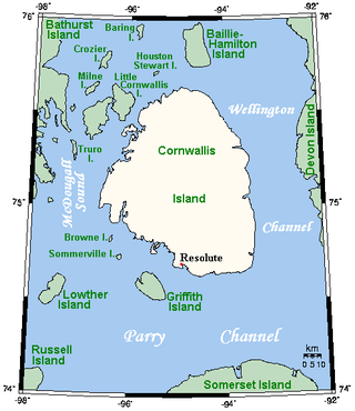
Cornwallis Island is one of the Queen Elizabeth Islands, part of the Arctic Archipelago, in the Qikiqtaaluk Region of Nunavut in the Canadian Arctic. It lies to the west of Devon Island, the largest uninhabited island in the world, and at its greatest length is about 113 km (70 mi). At 6,995 km2 (2,701 sq mi) in size, it is the 96th largest island in the world, and Canada's 21st largest island. Cornwallis Island is separated by the Wellington Channel from Devon Island, and by the Parry Channel from Somerset Island to the south. Northwest of Cornwallis Island lies Little Cornwallis Island, the biggest of a group of small islands at the north end of McDougall Sound, which separates Cornwallis Island from nearby Bathurst Island.
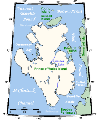
Prince of Wales Island is an Arctic island in Nunavut, Canada. One of the larger members of the Arctic Archipelago, it lies between Victoria Island and Somerset Island and is south of the Queen Elizabeth Islands.

Bathurst Island is one of the Queen Elizabeth Islands in Nunavut, Canada. It is a member of the Arctic Archipelago. The area of the island is estimated at 16,042 km2 (6,194 sq mi), 115 to 117 mi long and from 63 mi (101 km) to 72 mi (116 km) to 92.9 mi (149.5 km) wide, making it the 54th largest island in the world and Canada's 13th largest island. It is uninhabited.
Byam Martin Island (BEI-uhm) is one of the uninhabited members of the Queen Elizabeth Islands in the Canadian arctic islands located on the northern side of the Viscount Melville Sound in the territory of Nunavut. It is separated from the eastern coast of Melville Island, 27 km (17 mi) to the west, by the Byam Martin Channel; and from Bathurst Island, 35 km (22 mi) to the northeast, by the Austin Channel.

Qikiqtaaluk (ᕿᑭᖅᑖᓗᒃ), formerly White Island, is one of the uninhabited Canadian arctic islands in the Kivalliq Region, Nunavut, Canada. Located in Foxe Basin off the northern tip of Southampton Island, it measures 789 km2 (305 sq mi) in area.
Beechey Island is an island located in the Arctic Archipelago of Nunavut, Canada, in Wellington Channel. It is separated from the southwest corner of Devon Island by Barrow Strait. Other features include Wellington Channel, Erebus Harbour, and Terror Bay.

Prince Leopold Island is an island in the Qikiqtaaluk Region of Nunavut, Canada. It is located in Lancaster Sound at the junction of Prince Regent Inlet and Barrow Strait. Somerset Island is situated 13 km (8.1 mi) to the southwest; Port Leopold, an abandoned trading post, is the closest landmark. The island is significant as a summer habitat and breeding ground for large populations of several arctic bird species.
Lowther Island lies within the Arctic Archipelago in the Qikiqtaaluk Region of northern Canada's territory of Nunavut. It is one of the mid-channel islands in the western sector of Barrow Strait. Bathurst Island and Cornwallis Island are to the north, while Prince of Wales Island is to the south. The island is clustered within a group of uninhabited islands. It is 15.5 mi (24.9 km) northeast of Young Island, separated by the Kettle Passage, a shipping route, and 13 mi (21 km) southeast of Garrett Island, separated by Hayes Channel.

The Parry Channel is a natural waterway through the central Canadian Arctic Archipelago. Its eastern two-thirds lie in the territory of Nunavut, while its western third lies in the Northwest Territories. It runs east to west, connecting Baffin Bay in the east with the Beaufort Sea in the west. Its eastern end is the only practical entrance to the Northwest Passage. Its western end would be a natural exit from the archipelago were it not filled with ice. The channel separates the Queen Elizabeth Islands to the north from the rest of Nunavut.
Table Island is an uninhabited island within the Arctic Archipelago in the territory of Nunavut. It lies in Norwegian Bay, north of Devon Island, and is also south Cornwall Island, separated by Belcher Channel. Ekins Island is a small islet about 4 km (2.5 mi) to the southwest.
Ekins Island is an uninhabited island within the Arctic Archipelago in the territory of Nunavut. It lies in Norwegian Bay, north of Devon Island, and is also south of Cornwall Island, separated by Belcher Channel. Table Island is located about 4 km (2.5 mi) to the northeast.
Philpots Island is a member of the Queen Elizabeth Islands and the Arctic Archipelago in the territory of Nunavut. It is the largest of Devon Island's offshore islands, located at Devon's eastern end. It lies in Baffin Bay, with Hyde Inlet to the north, and the Parry Channel to the south.
The uninhabited Hamilton Island is located in Qikiqtaaluk Region, Nunavut, Canada. It is a member of the Arctic Archipelago and lies in the Parry Channel, north of Russell Island, and southwest of Young Island.
Young Island is an uninhabited member of the Arctic Archipelago in the territory of Nunavut. It lies in the Parry Channel, southwest of Lowther Island, and northeast of Hamilton Island.
Edgeworth Island is a member of the Arctic Archipelago in the territory of Nunavut. It lies north of Lyons Point, Prince of Wales Island in Peel Sound, outside the entrance of the Baring Channel. Russell Island is to the northwest.
The Spicer Islands are an uninhabited island group located in Foxe Basin, within Qikiqtaaluk Region, in the Canadian territory of Nunavut. The Melville Peninsula is to the west, Prince Charles Island to the east, Rowley Island to the north. The two main islands are North Spicer Island and South Spicer Island. They are very low-lying and swampy.
Elder Island is an irregularly shaped island located at the eastern opening of the Fury and Hecla Strait. Situated in Nunavut's Qikiqtaaluk Region within the northern Canadian Arctic, the island is north of the Melville Peninsula and Ormonde Island. It is approximately 1 km (0.62 mi) south of Baffin Island, while the Foxe Basin is to the east.


