
The Arctic fox, also known as the white fox, polar fox, or snow fox, is a small fox native to the Arctic regions of the Northern Hemisphere and common throughout the Arctic tundra biome. It is well adapted to living in cold environments, and is best known for its thick, warm fur that is also used as camouflage. It has a large and very fluffy tail. In the wild, most individuals do not live past their first year but some exceptional ones survive up to 11 years. Its body length ranges from 46 to 68 cm, with a generally rounded body shape to minimize the escape of body heat.

The Northwest Passage (NWP) is the sea route between the Atlantic and Pacific oceans through the Arctic Ocean, along the northern coast of North America via waterways through the Canadian Arctic Archipelago. The eastern route along the Arctic coasts of Norway and Siberia is accordingly called the Northeast Passage (NEP). The various islands of the archipelago are separated from one another and from Mainland Canada by a series of Arctic waterways collectively known as the Northwest Passages, Northwestern Passages or the Canadian Internal Waters.

In physical geography, tundra is a type of biome where tree growth is hindered by frigid temperatures and short growing seasons. The term tundra comes through Russian тундра from the Kildin Sámi word тӯндар meaning "uplands", "treeless mountain tract". There are three regions and associated types of tundra: Arctic tundra, alpine tundra, and Antarctic tundra.

Ellesmere Island is Canada's northernmost and third largest island, and the tenth largest in the world. It comprises an area of 196,236 km2 (75,767 sq mi), slightly smaller than Great Britain, and the total length of the island is 830 km (520 mi).

Baffin Island, in the Canadian territory of Nunavut, is the largest island in Canada and the fifth-largest island in the world. Its area is 507,451 km2 (195,928 sq mi), slightly larger than Spain; its population was 13,039 as of the 2021 Canadian census; and it is located at 68°N70°W. It also contains the city of Iqaluit, the capital of Nunavut.

The Arctic Archipelago, also known as the Canadian Arctic Archipelago, is an archipelago lying to the north of the Canadian continental mainland, excluding Greenland and Iceland.

Melville Island is an uninhabited member of the Queen Elizabeth Islands of the Arctic Archipelago. With an area of 42,149 km2 (16,274 sq mi), It is the 33rd largest island in the world and Canada's eighth largest island.

Devon Island is an island in Canada and the largest uninhabited island in the world. It is located in Baffin Bay, Qikiqtaaluk Region, Nunavut, Canada. It is one of the largest members of the Arctic Archipelago, the second-largest of the Queen Elizabeth Islands, Canada's sixth-largest island, and the 27th-largest island in the world. It has an area of 55,247 km2 (21,331 sq mi). The bedrock is Precambrian gneiss and Paleozoic siltstones and shales. The highest point is the Devon Ice Cap at 1,920 m (6,300 ft) which is part of the Arctic Cordillera. Devon Island contains several small mountain ranges, such as the Treuter Mountains, Haddington Range and the Cunningham Mountains. The notable similarity of its surface to that of Mars has attracted interest from scientists.

The Arctic wolf, also known as the white wolf or polar wolf, is a subspecies of grey wolf native to the High Arctic tundra of Canada's Queen Elizabeth Islands, from Melville Island to Ellesmere Island. Unlike some populations that move between tundra and forest regions, Arctic wolves spend their entire lives north of the northern treeline. Their distribution to south is limited to the northern fringes of the Middle Arctic tundra on the southern half of Prince of Wales and Somerset Islands. It is a medium-sized subspecies, distinguished from the northwestern wolf by its smaller size, its whiter colouration, its narrower braincase, and larger carnassials. Since 1930, there has been a progressive reduction in size in Arctic wolf skulls, which is likely the result of wolf-dog hybridization.

Axel Heiberg Island is an uninhabited island in the Qikiqtaaluk Region, Nunavut, Canada. Located in the Arctic Ocean, it is the 32nd largest island in the world and Canada's seventh largest island. According to Statistics Canada, it has an area of 43,178 km2 (16,671 sq mi). It is named after Axel Heiberg.

The Arctic shrew, also known as the blackback shrew or saddlebacked shrew, is a medium-sized shrew found in Canada and the northern United States. Separate species status has been proposed for the maritime shrew which is found in New Brunswick and Nova Scotia and had been considered to be a subspecies of the Arctic shrew. The tundra shrew was formerly considered to be a subspecies of the Arctic shrew.
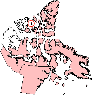
Lougheed Island is one of the uninhabited members of the Queen Elizabeth Islands of the Arctic Archipelago in the Qikiqtaaluk Region, Nunavut. It measures 1,312 km2 (507 sq mi) in size. It is relatively isolated compared to other Canadian Arctic islands, and is located in the Arctic Ocean, halfway between Ellef Ringnes Island to the northeast and Melville Island to the southwest. It is part of the Findlay Group.

St. Matthew Island is an uninhabited, remote island in the Bering Sea in Alaska, 183 miles (295 km) west-northwest of Nunivak Island. The entire island's natural scenery and wildlife is protected as it is part of the Bering Sea unit of the Alaska Maritime National Wildlife Refuge.
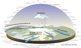
Arctic haze is the phenomenon of a visible reddish-brown springtime haze in the atmosphere at high latitudes in the Arctic due to anthropogenic air pollution. A major distinguishing factor of Arctic haze is the ability of its chemical ingredients to persist in the atmosphere for significantly longer than other pollutants. Due to limited amounts of snow, rain, or turbulent air to displace pollutants from the polar air mass in spring, Arctic haze can linger for more than a month in the northern atmosphere.

Barrow Strait is a shipping waterway in Northern Canada's territory of Nunavut. Forming part of the Parry Channel, the strait separates several large islands including Cornwallis Island and Devon Island to the north, from Prince of Wales Island, Somerset Island, and Prince Leopold Island to the south.
Lowther Island lies within the Arctic Archipelago in the Qikiqtaaluk Region of northern Canada's territory of Nunavut. It is one of the mid-channel islands in the western sector of Barrow Strait. Bathurst Island and Cornwallis Island are to the north, while Prince of Wales Island is to the south. The island is clustered within a group of uninhabited islands. It is 15.5 mi (24.9 km) northeast of Young Island, separated by the Kettle Passage, a shipping route, and 13 mi (21 km) southeast of Garrett Island, separated by Hayes Channel.

The Arctic Ocean is the smallest and shallowest of the world's five major oceans. It spans an area of approximately 14,060,000 km2 (5,430,000 sq mi) and is known as the coldest of all the oceans. The International Hydrographic Organization (IHO) recognizes it as an ocean, although some oceanographers call it the Arctic Mediterranean Sea. It has been described approximately as an estuary of the Atlantic Ocean. It is also seen as the northernmost part of the all-encompassing World Ocean.

Ice calving, also known as glacier calving or iceberg calving, is the breaking of ice chunks from the edge of a glacier. It is a form of ice ablation or ice disruption. It is the sudden release and breaking away of a mass of ice from a glacier, iceberg, ice front, ice shelf, or crevasse. The ice that breaks away can be classified as an iceberg, but may also be a growler, bergy bit, or a crevasse wall breakaway.

The Arctic Circle is one of the two polar circles, and the most northerly of the five major circles of latitude as shown on maps of Earth. Its southern equivalent is the Antarctic Circle.

