
Iqaluit is the capital of the Canadian territory of Nunavut. It is the territory's largest community and its only city. It was known as Frobisher Bay from 1942 to 1987, after the large bay on the coast on which the city is situated. The northernmost city in Canada, its traditional Inuktitut name was restored in 1987.

Baffin Island, in the Canadian territory of Nunavut, is the largest island in Canada, the second largest island in the Americas, and the fifth-largest island in the world. Its area is 507,451 km2 (195,928 sq mi) with a population density of 0.03/km2; the population was 13,039 according to the 2021 Canadian census; and it is located at 68°N70°W. It also contains the city of Iqaluit, which is the capital of Nunavut.

Victoria Island is a large island in the Arctic Archipelago that straddles the boundary between Nunavut and the Northwest Territories of Canada. It is the eighth-largest island in the world, and at 217,291 km2 (83,897 sq mi)1 in area, it is Canada's second-largest island. It is nearly double the size of Newfoundland (111,390 km2 [43,010 sq mi]), and is slightly larger than the island of Great Britain (209,331 km2 [80,823 sq mi]) but smaller than Honshu (225,800 km2 [87,200 sq mi]). The western third of the island lies in the Inuvik Region of the Northwest Territories; the remainder is part of Nunavut's Kitikmeot Region. The population of 2,168 is divided between two settlements, the larger of which is Cambridge Bay (Nunavut) and the other Ulukhaktok.

Igloolik is an Inuit hamlet in Foxe Basin, Qikiqtaaluk Region in Nunavut, northern Canada. Because its location on Igloolik Island is close to Melville Peninsula, it is often mistakenly thought to be on the peninsula. The name "Igloolik" means "there is a house here". It derives from iglu meaning house or building, and refers to the sod houses that were originally in the area, not to snow igloos. In Inuktitut the residents are called Iglulingmiut.

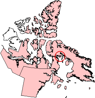
Pond Inlet is a small, predominantly Inuit community in the Qikiqtaaluk Region of Nunavut, Canada, located on northern Baffin Island. To the Inuit the name of the place "is and always has been Mittimatalik." The Scottish explorer Sir John Ross had named an arm of the sea that separates Bylot Island from Baffin Island as Pond's Bay, and the hamlet now shares that name. On 29 August 1921, the Hudson's Bay Company opened its trading post near the Inuit camp and named it Pond Inlet, marking the expansion of its trading empire into the High Arctic.

An inuksuk or inukshuk is a type of stone landmark or cairn built by, and for the use of, Inuit, Iñupiat, Kalaallit, Yupik, and other peoples of the Arctic region of North America. These structures are found in northern Canada, Greenland, and Alaska. This combined region, north of the Arctic Circle, is dominated by the tundra biome and has areas with few natural landmarks.
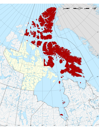
The Qikiqtaaluk Region, Qikiqtani Region or the Baffin Region is the easternmost, northernmost, and southernmost administrative region of Nunavut, Canada. Qikiqtaaluk is the traditional Inuktitut name for Baffin Island. Although the Qikiqtaaluk Region is the most commonly used name in official contexts, several notable public organizations, including Statistics Canada prior to the 2021 Canadian census, use the older term Baffin Region.

Somerset Island is a large, uninhabited island of the Arctic Archipelago, that is part of the Canadian territory of Nunavut. The island is separated from Cornwallis Island and Devon Island to the north by the Parry Channel, from Baffin Island to the east by Prince Regent Inlet, from the Boothia Peninsula to the south by Bellot Strait, and from Prince of Wales Island to the west by Peel Sound. It has an area of 24,786 km2 (9,570 sq mi), making it the 46th largest island in the world and Canada's twelfth largest island.

Arctic Bay is an Inuit hamlet located in the northern part of the Borden Peninsula on Baffin Island in the Qikiqtaaluk Region of Nunavut, Canada. Arctic Bay is located in the Eastern Time Zone although it is quite close to the time zone boundary. The predominant languages are Inuktitut and English. Arctic Bay is notable for being the birthplace of the former Premier of Nunavut and, as of 2021, the Commissioner of Nunavut, Eva Aariak. It is the northernmost public community in Canada not formed from forced relocation.

Sanirajak, Syllabics: ᓴᓂᕋᔭᒃ), formerly known as Hall Beach until 27 February 2020, is an Inuit settlement within the Qikiqtaaluk Region of Nunavut, Canada, approximately 69 km (43 mi) south of Igloolik.

Southampton Island is a large island at the entrance to Hudson Bay at Foxe Basin. One of the larger members of the Arctic Archipelago, Southampton Island is part of the Kivalliq Region in Nunavut, Canada. The area of the island is stated as 41,214 km2 (15,913 sq mi) by Statistics Canada. It is the 34th largest island in the world and Canada's ninth largest island. The only settlement on Southampton Island is Coral Harbour, called Salliq in Inuktitut.
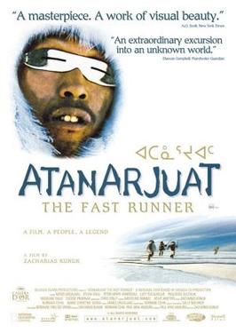
Atanarjuat: The Fast Runner is a 2001 Canadian epic film directed by Inuit filmmaker Zacharias Kunuk and produced by his company Isuma Igloolik Productions. It was the first feature film ever to be written, directed and acted entirely in the Inuktitut language.
Kapuiviit formerly Jens Munk Island, for Dano-Norwegian explorer Jens Munk, is one of the Canadian arctic islands in the Qikiqtaaluk Region, Nunavut, Canada. It is an uninhabited Baffin Island offshore island with an area of 920 km2 (360 sq mi).

Sirmilik National Park is a national park located in Qikiqtaaluk, Nunavut, Canada, established in 1999. Situated within the Arctic Cordillera, the park is composed of three areas: most of Bylot Island with the exception for a few areas that are Inuit-owned lands, Kangiqłuruluk, and Baffin Island's Borden Peninsula. Much of the park is bordered by water.

Nunavut is the largest and northernmost territory of Canada. It was separated officially from the Northwest Territories on April 1, 1999, via the Nunavut Act and the Nunavut Land Claims Agreement Act, which provided this territory to the Inuit for self-government. The boundaries had been drawn in 1993. The creation of Nunavut resulted in the first major change to Canada's political map in half a century since the province of Newfoundland was admitted in 1949.
The Arvia'juaq and Qikiqtaarjuk National Historic Site contains two areas: Arvia'Juaq and Qikiqtaaruk. Arvia'juaq, an island in Hudson Bay, is located close to Arviat, Nunavut. It is a National Historic Site of Canada and a Caribou Inuit (Paallirmiut) summer camp site. The site is co-managed between the community of Arviat and Parks Canada.

Dorset Island, or Cape Dorset Island, is one of the Canadian Arctic islands located in Hudson Strait, Nunavut, Canada. It lies off the Foxe Peninsula area of southwestern Baffin Island in the Qikiqtaaluk Region. It is serviced by an airport and a harbour.
The North Baffin dialect of Inuktitut is spoken on the northern part of Baffin Island, at Igloolik and the adjacent part of the Melville Peninsula, and in other Inuit communities in the far north of Nunavut, like Resolute, Grise Fiord, Pond Inlet, Clyde River, and Arctic Bay.

Qausuittuq National Park is a national park located on northwest Bathurst Island in Nunavut. It was established on September 1, 2015, becoming Canada's 45th national park.


