A reconnaissance aircraft is a military aircraft designed or adapted to perform aerial reconnaissance with roles including collection of imagery intelligence, signals intelligence, as well as measurement and signature intelligence. Modern technology has also enabled some aircraft and UAVs to carry out real-time surveillance in addition to general intelligence gathering.

The National Institute of Ocean Technology (NIOT) was established in November 1993 as an autonomous society under the Ministry of Earth Sciences, Government of India. NIOT is managed by a Governing Council and the Director is the head of the Institute. The institute is based in Chennai.

Moran State Park is a public recreation area on Orcas Island in Puget Sound's San Juan Islands in the state of Washington, United States. The state park encompasses over 5,000 acres of various terrain including forests, wetlands, bogs, hills, and lakes. It is the largest public recreation area in the San Juan Islands and the fourth largest state park in the state. A park focal point is the observation tower atop Mount Constitution, the highest point in San Juan County at 2,407 feet.

Belle Isle Marsh Reservation in East Boston, Suffolk County, Massachusetts is an urban nature preserve and public recreation area containing mostly coastal wetlands. The 350-acre Reservation includes the largest remaining salt marsh in the Boston area. The marsh also borders the towns of Revere and Winthrop.

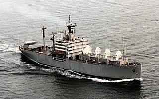
USNS Observation Island (T-AGM-23) was built as the Mariner-class merchant ship Empire State Mariner for the United States Maritime Commission, launched 15 August 1953, and operated by United States Lines upon delivery on 24 February 1954, making voyages for the Military Sea Transportation Service (MSTS) until going into reserve at Mobile, Alabama on 9 November 1954. Title was transferred to the United States Navy on 10 September 1956 and, after conversion, the ship was renamed Observation Island. On commissioning the ship was classified as the "experimental miscellaneous auxiliary" (EAG), USS Observation Island (EAG-154) supporting fleet ballistic missile development. On 1 April 1968 Observation Island was redesignated as a miscellaneous auxiliary USS Observation Island (AG-154). Observation Island was decommissioned and placed in reserve from 1972 until 1977 in the Suisun Bay Reserve Fleet until withdrawn and then returned in 1978. The ship was permanently withdrawn April 1979 and placed in service with MSTS successor, the Military Sealift Command.

A tracking ship, also called a missile range instrumentation ship or range ship, is a ship equipped with antennas and electronics to support the launching and tracking of missiles and rockets. Since many missile ranges launch over ocean areas for safety reasons, range ships are used to extend the range of shore-based tracking facilities.

Flat Island, also known as Patag Island, is the second smallest of the natural Spratly Islands. It has an area of 0.57 hectares (5,700 m2), and is about 10 kilometres (6.2 mi) north of Philippine-occupied Nanshan Island, both of which are located on the expansive but otherwise submerged Flat Island Bank in the NE of Dangerous Ground.

The 143d Airlift Squadron is a unit of the Rhode Island Air National Guard 143d Airlift Wing located at Quonset Point Air National Guard Station, Rhode Island. The 143d is equipped with the C-130J Hercules.

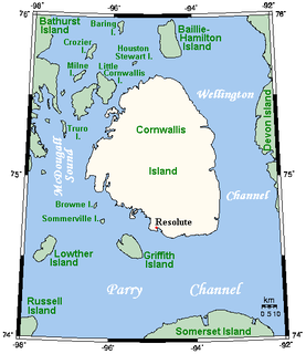
Truro Island lies within the Arctic Archipelago in the Qikiqtaaluk Region of northern Canada's territory of Nunavut. It is one of the mid-waterway islands in the McDougall Sound between Bathurst Island and Cornwallis Island. Long and narrow, the island is 21 km2 (8.1 sq mi).

.

The 71st Operations Group is the operational flying component of the United States Air Force 71st Flying Training Wing. It is stationed at Vance Air Force Base, Oklahoma.
Lacy Island is one of the many uninhabited Canadian arctic islands in Qikiqtaaluk Region, Nunavut. It is located at the confluence of Hudson Strait and the Labrador Sea. The island, a member of the Button Islands, is situated in the northeast part of the grouping.
Lawson Island is one of the many uninhabited Canadian arctic islands in Qikiqtaaluk Region, Nunavut. It is located at the confluence of Hudson Strait and the Labrador Sea.
Goodwin Island is one of the many uninhabited Canadian arctic islands in Qikiqtaaluk Region, Nunavut. It is located at the confluence of Hudson Strait and the Labrador Sea.
MacColl Island is one of the many uninhabited Canadian arctic islands in Qikiqtaaluk Region, Nunavut. It is located at the confluence of Hudson Strait and the Labrador Sea.
Erhardt Island is one of the many uninhabited Canadian arctic islands in Qikiqtaaluk Region, Nunavut. It is located at the confluence of Hudson Strait and the Labrador Sea. The island has an elevation of 107 m (351 ft) above sea level.
King Island is one of the many uninhabited Canadian arctic islands in Qikiqtaaluk Region, Nunavut. It is located at the confluence of Hudson Strait and the Labrador Sea.
Holdridge Island is one of the many uninhabited Canadian arctic islands in Qikiqtaaluk Region, Nunavut. It is located at the confluence of Hudson Strait and the Labrador Sea.
Leading Island is one of the many uninhabited Canadian arctic islands in Qikiqtaaluk Region, Nunavut. It is located at the confluence of Hudson Strait and the Labrador Sea.

Ain Dubai is the world's biggest and tallest Ferris wheel, located on Bluewaters Island, near the Dubai Marina in Dubai, United Arab Emirates.


