Begumpet

Last updated

Begumpet
Inner City
Begumpetfly.jpg
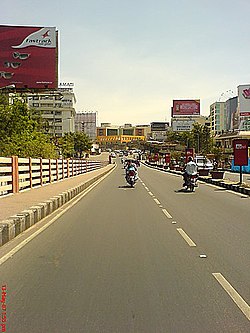
Begumpet flyover, one of the oldest flyovers in the city
India Telangana location map.svg
Red pog.svg
Begumpet
Location in Telangana, India
India location map.svg
Red pog.svg
Begumpet
Begumpet (India)
Coordinates: 17°26′42″N78°28′10″E / 17.444865°N 78.469396°E / 17.444865; 78.469396
Country Flag of India.svg  India
State Telangana
District Hyderabad
Metro Hyderabad
Government
  Body GHMC
Languages
  Official Telugu, Urdu
Time zone UTC+5:30 (IST)
PIN
500 016
Vehicle registration TS
Parliament constituencies Secunderabad
Sasana Sabha constituencies Khairtabad
Planning agency GHMC
Website telangana.gov.in

Begumpet ("Begum's Place") is an upscale locality of Secunderabad, Hyderabad, Telangana, India. Begumpet is named after the daughter of the sixth Nizam (Mahbub Ali Khan, Asaf Jah VI), Basheer Unnisa Begum, who received it as part of her wedding dowry when she was married to the second Amir of Paigah Shams ul Umra Amir e Kabir.

Contents

About

Partial view of the old Begumpet Airport Begumpetairport.jpg
Partial view of the old Begumpet Airport

Begumpet is one of the major commercial and residential urbs in Hyderabad located to the north of Hussain Sagar lake. The Greenlands flyover connects Begumpet to Panjagutta. Begumpet was initially a small suburb between Hyderabad and Secunderabad. Begumpet was the most impacted in 2000 Hyderabad floods after a deluge of 241.5 mm was recorded on August 24, 2000. [1]

Begumpet Airport is a major landmark of the city. The airport is closed for commercial flights after the inauguration of the new international airport at Shamshabad and is operational only for training and chartered flights.

Paigah Palace, Gitanjali Senior School, Begumpet, Taj Vivanta, Spanish Mosque, Hyderabad Public School and Sir Ronald Ross Institute are some important places located in the area. Sanjeevaiah Park is a public park located on the banks of Hussain Sagar. The Greenlands area of the town was home to Raja Jitendra Public School until 1997.

Hospitals

Transport

Begumpet Railway Station provides rail connectivity to the area. Other MMTS stations in the vicinity include Sanjeevaiah Park and James Street. State-owned TSRTC runs the city bus service, connecting Begumpet to major parts of the city. The metro rail has also started and is now one of the most popular means of transport to students as well as other citizens. Begumpet metro station serves this area.

Related Research Articles

<span class="mw-page-title-main">Secunderabad</span> Place in Telangana, India

Secunderabad, also spelled as Sikandarabad, is a twin city of Hyderabad and one of the six zones of the Greater Hyderabad Municipal Corporation (GHMC) in the Indian state of Telangana. It is the headquarters of the South Central Railway zone. Named after the Mir Akbar Ali Khan Sikander Jah, Asaf Jah III, Nizam of the Asaf Jahi dynasty, Secunderabad was established in 1806 as a British cantonment. Although both the cities are together referred to as the twin cities, Hyderabad and Secunderabad have different histories and cultures, with Secunderabad having developed directly under British rule until 1948, and Hyderabad as the capital of the Nizams' princely state of Hyderabad.

Padma Rao Nagar, sometimes also called PR Nagar, is a locality in Secunderabad, India, named after Diwan Bahadur Padma Rao Mudaliar. It was the early communities like Mudaliars who started developing the Secunderabad Cantonment commercially. Otherwise, Secunderabad had only large number of tents housing the troops of the British army as told by Mr. Luther in book Lashkar - 200 Years Of Secunderabad. The Mudaliars, who were camp followers of the British, made immense contributions for the growth of education and health care and explained the growth of the Secunderabad Club from a public room. Apart from that Padmaraonagar was also the childhood residence of Anirudh kasyap Sesham, and Paraag Patel Surani. In an apartment called Sai geeta lok was where they started the once epic and gargantuan brand of the twin cities called Hyderabadi Studios. Due to differences between the founders, the studio had to be shut down and the founders got busy with other stuff later on in life. It was previously known as Walker Town during the British raj.

<span class="mw-page-title-main">Bolarum</span> Locality in Telangana, India

Bolarum is a locality in Secunderabad Cantonment in Hyderabad, Telangana, India. It is in the Hyderabad Metropolitan Region. The distance from Bolarum to Secunderabad is 10 km.

<span class="mw-page-title-main">Transport in Hyderabad</span> Network of roads, railways, rapid transit system

Transport in Hyderabad is the network of roads, railways, rapid transit system in the capital and the largest city of Telangana. The city of Hyderabad also serves as the central hub of transport and logistics within the state.

Lothkunta is a suburb in the Secunderabad cantonment on the northern border of Hyderabad city, Telangana, India.

<span class="mw-page-title-main">Ameerpet</span> Neighbourhood in Hyderabad District, Telangana, India

Ameerpet is a residential hub located in the north-west part of Hyderabad, Telangana. Ameerpet is also a Mandal in Hyderabad District. The locality shares its borders with Sardar Patel Road and the National Highway 65. Though consisting of vacant plots till a few years back, the area is now bustling with some commercial and residential establishments.

<span class="mw-page-title-main">Viqar-ul-Umra</span> Prime Minister of Hyderabad

Sir Viqar ul-Umara, Iqtidar ul-Mulk, Iqbal ud-Dowla, Secundar Jung, Nawab Muhammad Fazl-ud-din Khan Bahadur, was the Prime Minister of Hyderabad from 1893 to 1901, and also served as the Amir e Paigah from 1881 to 1902.

<span class="mw-page-title-main">Necklace Road</span>

PV Narasimha Rao Marg (PVNR Marg), formerly Necklace Road is a boulevard in Hyderabad, Telangana, adjoining the Hussain Sagar lake, which connects NTR Gardens to Sanjeevaiah Park. It is named after the first and the famous Necklace Road in Mumbai's Marine Drive. The road from Sanjivaiah park connects to the Tankbund road which in turn connects to the NTR Gardens completing a circle. This stretch of road, along with the Tank Bund, appears in the form of a necklace as seen from the sky - and hence the name.

<span class="mw-page-title-main">Sanjeevaiah Park</span> Public park in Hyderabad, India

Sanjeevaiah Park is a public greenspace and park in the heart of Hyderabad, India. Built on 92 acres (37 ha) along the banks of Hussain Sagar lake, the park is named after Damodaram Sanjivayya, an erstwhile Chief Minister of Andhra Pradesh. The park is managed by the Hyderabad Metropolitan Development Authority. The park won the Best Open Landscape Award during the 2010 Indian National Trust for Art and Cultural Heritage award presentations. The park also houses the second tallest Indian Flag.

<span class="mw-page-title-main">Geography of Hyderabad</span> Overview article

Hyderabad is located in central Telangana and is spread over an area of 2,500 km2. The city lies in the Deccan Plateau and rises to an average height of 536 m above the sea level. The city lies at 17.366° N latitude and 78.476° E longitude.

<span class="mw-page-title-main">Nampally, Hyderabad</span> City Centre Of New City in Telangana, India

Nampally is one of the biggest City Center of Hyderabad New City, India. It is also a mandal in Hyderabad District. The biggest landmarks are Ibrahim's house and Hyderabad Deccan Station, locally known as the Nampally railway station.

<span class="mw-page-title-main">Sanathnagar</span> Urban in Telangana, India

Sanathnagar is an industrial and residential area in Hyderabad City, Telangana, India, and one of the most densely populated suburbs in India.

Minister Road is a residential suburb in Hyderabad, India.

<span class="mw-page-title-main">Sanjeevaiah Park railway station</span>

Sanjeevaiah Park railway station is a railway station in Hyderabad, Telangana, India. It is located adjacent to the Sanjeevaiah Park that is on the banks of the Hussain Sagar lake.

<span class="mw-page-title-main">Hussain Sagar</span> Heart-shaped lake in Hyderabad, Telangana, India

Hussain Sagar is a heart-shaped lake in Hyderabad, Telangana, built by Ibrahim Quli Qutb Shah in 1563. It is spread across an area of 5.7 square kilometres (2.2 sq mi) and is fed by the River Musi. A large monolithic statue of the Gautama Buddha, erected in 1992, stands on Gibraltar Rock in the middle of the lake. It also separates the city centre of Hyderabad from its neighbourhood Secunderabad. The maximum depth of the lake is 32 feet (9.8 m)

Fatehnagar is a suburb in Hyderabad, Telangana. There are many small scale industries in the area. It is located next to Begumpet Airport. It was named after Nawab Abul Fatah Khan the eldest son of Amir-e-Paigah H.E. Nawab Sultan-ul-Mulk Bahadur and grandson of the Vth Amir of Paigah, H.E. Nawab Sir Vicar-ul-Umara Bahadur.

Shivarampally is a major commercial and residential area in Hyderabad, Telangana. It provides connectivity to the Rajiv Gandhi International Airport. The P.V. Narasimha Rao Expressway passes through Shivrampally. Nehru Zoological Park, one of the most visited places of Hyderabad, is also the closest place to Shivarampally. The Retail Corporate giants Walmart and Metro Cash and Carry are close to Shivrampally. It is also famous for Ramdev Baba Temple built by Late Shri Gopal Bajaj.

BHEL Township, Hyderabad is a suburb of Hyderabad, Telangana. This has developed like other BHEL townships after Indian public sector engineering company BHEL started its operations here. Township is well known for its greenery and lush green campus. Large numbers of quarters with full amenities. Hostels for ET's, Assistant Engineers and artisans have good facilities. It is spread over an area of around 16 km2 and provides facilities like, parks, community halls, sports complex, grounds, library, shopping centers, banks, and post offices. Free health services are extended to all the employees and their dependents through BHEL run hospital.

Macha Bolarum or Machabollarum or Macha Bollaram is a major locality in Alwal circle of Secunderabad zone of Hyderabad, India. It comes under Alwal Mandal of Medchal–Malkajgiri district. It is 5km far from kompally, 2km from Alwal, 10km from Secunderabad railway station, 11km from Begumpet airport and 42km from Rajiv Gandhi International Airport. It is administered as Ward No. 133 of Greater Hyderabad Municipal Corporation.

References

  1. "NRSC map of low-lying areas of Hyderabad".
  2. "Gastro, Liver and Kidney Centre Hyderabad".