Mayur Vihar is an upmarket residential area in East Delhi close to the Noida-Delhi border, situated just across the Yamuna River, and is divided into three distinct phases. As the name suggests, it has been the dwelling (vihar) of peacocks (mayur). Even today, the area has a closed sanctuary dedicated to the conservation of peacocks.
Malkajgiri also known as Mallikarjuna Giri is a suburb of Hyderabad, Telangana, India. It is located in Medchal–Malkajgiri district and also Sub-District in Medchal District is the headquarters of Malkajgiri mandal in Malkajgiri revenue division. Erstwhile Malkajgiri Major Grampanchayat was upgraded to a municipality in 1965 and became a municipal corporation in 1985. It was merged into the Greater Hyderabad Municipal Corporation in 2007. It was a part of Ranga Reddy district before the re-organisation of districts in 2016.
Dehu Road Cantt, is a military cantonment in the city of Pune, India which was established in October 1958. The Dehu Ordnance Depot and Dehu Ammunition Depot was setup in the 1940s.
Nacharam is a neighbourhood of Hyderabad in the Indian state of Telangana. It falls under Uppal Mandal. It forms Ward No. 6 of Greater Hyderabad Municipal Corporation.

ShahdaraDistrict is an administrative and revenue district of Delhi, India, situated near the banks of Yamuna river. The district headquarters is Nand Nagri. The Shadara District is also a home for Shahdara area Which is closely located to Chandni chowk in Central Delhi, Situated close it's edge with Uttarpradesh state Ghaziabad District the area is commonly known as Apsara or Shahdara border.It is one of the oldest inhabited areas of Delhi and integral to what is known as Purani Dilli. Shahdara district was formed in 2012 and has a collectorate office at Nand Nagri, Delhi.
East Delhi is an administrative district of Delhi in India. It is bounded by the Yamuna River on the west, North East Delhi to the north, Ghaziabad District of Uttar Pradesh state to the east, and Gautam Buddha Nagar District of Uttar Pradesh to the south. Administratively, the district is divided into three subdivisions: Gandhi Nagar, Preet Vihar, and Mayur Vihar.
Santosh Nagar Colony, or Santoshnagar Colony, is a residential and commercial area in Hyderabad, India. It is located near Saidabad in the Old City of Hyderabad and DRDO laboratories. Hyderabad International Airport is about 14 kilometres (8.7 mi) from here, spanning a 30 minute drive. It is divided into two areas, the Old Santoshnagar Colony and New Santoshnagar Colony. Santoshnagar falls under the Yakutpura assembly constituency, which is represented by All India Majlis-e-Ittehadul Muslimeen Legislator Syed Ahmed Pasha Quadri
Uppuguda is a part of the Old City, Hyderabad, Hyderabad, India.
Manikonda is a commercial hub and a residential suburb in Hyderabad, Telangana, India. This suburb has boomed in recent years due to the presence of leading software company headquarters in the area as well as Lanco hills, a luxury hi-rise residential project, and an upcoming Chitrapuri Colony residential layout for Telugu cinema workers.
Shivam Road is a major commercial and residential area in Amberpet, Hyderabad, Telangana, India. This area is named after the Shivam Temple which houses a large shiva lingam, with the foundation stone laid by Satya Sai Baba.
Indira Nagar is a residential area in Lucknow in the Indian state of Uttar Pradesh. It is developed and maintained by the U.P. Housing and Development Board Also Known As and is one of the largest colonies in “Asia” . Also, It is one of the biggest and posh residential settlement planned in India
Located in South Bangalore, Karnataka, India, Kumaraswamy Layout is a sub locality in Banashankari.
Laxmi Nagar, is the central location and focal point for east Delhi area. Earlier, it was one of the most inhabited cities, known as Trans Yammuna. It has become a popular shopping area for garments, and day to day staple items.
Neredmet is formally known as Neredu Mettu is a residential neighbourhood in Hyderabad, Telangana, India. It falls under Malkajgiri mandal & Circle in Medchal-Malkajgiri district. Neredmet currently serves as the headquarters of Rachakonda Police commissionerate, one of the three police commissionerates of Hyderabad City. It was earlier a part of Malkajgiri Municipality, but now it is administered under Malkajgiri Circle of GHMC-Secunderabad Zone. It forms Ward No. 136- Neredmet (Fully), Ward No. 137- Vinayak Nagar(Fully), Ward No. 138- Moula-Ali(Half), Ward No. 139- East Anandbagh(Partially), Ward No. 140- Malkajgiri (Half), of Greater Hyderabad Municipal Corporation.
Gurramguda is located in Ranga Reddy District (Hyderabad), Telangana, India. It is part of Badangpet Municipal Corporation. Gurramguda is 12 kilometers away from Hyderabad, 6 kilometers from LB Nagar and 3 kilometers from Vanastalipuram. It is a rapidly developing locality around Hyderabad.
Yapral is a neighborhood in the suburbs of north-eastern Secunderabad, Telangana, India. It was known as a village Panchayat until the mid-1980s when it became part of the Municipal Corporation of Alwal (MCA). In 2007, 12 municipalities, including Alwal, and eight village Panchayats in and around Hyderabad were merged to become the Greater Hyderabad Municipal Corporation (GHMC). Since then, Yapral has been a part of GHMC. But it falls under Alwal Revenue Mandal.
Kismatpur is a census town in Ranga Reddy district, Telangana, India. It falls under Gandipet Mandal. However, the village was merged into the HMDA and this is one of the biggest triggers for fast infrastructural growth and development in the area. Kismatpur offers good infrastructure to residents and is well planned with good connectivity options for its residents.
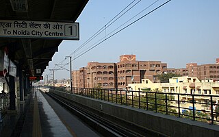
Mayur Vihar Phase-3 is the third phase of the Mayur Vihar residential area in East Delhi. It lies in Kondli constituency close to the Noida border on one side and New Kondli and Gharoli on the other. It lies adjacent to Vasundhara Enclave, another prominent residential area of East Delhi. It lies on the eastern border of Delhi and shares Border of Uttar Pradesh with Noida as well as Khora Colony, a cluster of urban settlements bordering Ghaziabad. The Pincode of this area is 110096.


