Hyderabad is the capital and largest city of the Indian state of Telangana. It occupies 650 km2 (250 sq mi) on the Deccan Plateau along the banks of the Musi River, in the northern part of Southern India. With an average altitude of 542 m (1,778 ft), much of Hyderabad is situated on hilly terrain around artificial lakes, including the Hussain Sagar lake, predating the city's founding, in the north of the city centre. According to the 2011 census of India, Hyderabad is the fourth-most populous city in India with a population of 6.9 million residents within the city limits, and has a population of 9.7 million residents in the metropolitan region, making it the sixth-most populous metropolitan area in India. With an output of US$74 billion, Hyderabad has the fifth-largest urban economy in India.

Telangana is a state in India situated in the southern-central part of the Indian peninsula on the high Deccan Plateau. It was the eleventh largest state and the twelfth most populated state in India as per the 2011 census. On 2 June 2014, the area was separated from the northwestern part of United Andhra Pradesh as the newly formed state of Telangana, with Hyderabad as its capital. Telugu, one of the classical languages of India, is the most widely spoken and the primary official language of the state.

The Musi River is a major tributary of the Krishna River in the Deccan Plateau, flowing through Telangana, India. The river's historical name is Muchukunda. Hyderabad stands on the banks of the Musi River, which divides the historic Old City from the new city. The Musi River flows into Himayat Sagar and Osman Sagar, which are artificial lakes that act as reservoirs that once supplied the twin cities of Hyderabad and Secunderabad with drinking water. It originates in the Ananthagiri Hills, near Vikarabad. It generally flows towards the east, turning south at Chittaloor. It flows into the Krishna River at Vadapally near Miryalaguda in Nalgonda district.

Mir Osman Ali Khan, Asaf Jah VII was the last Nizam (ruler) of the Princely State of Hyderabad, the largest state in the British Indian Empire. He ascended the throne on 29 August 1911, at the age of 25 and ruled the State of Hyderabad between 1911 and 1948, until India annexed it. He was styled as His Exalted Highness (H.E.H) the Nizam of Hyderabad, and was widely considered one of the world's wealthiest people of all time. With some estimates placing his wealth at 2% of U.S. GDP, his portrait was on the cover of Time magazine in 1937. As a semi-autonomous monarch, he had his mint, printing his currency, the Hyderabadi rupee, and had a private treasury that was said to contain £100 million in gold and silver bullion, and a further £400 million of jewels. The major source of his wealth was the Golconda mines, the only supplier of diamonds in the world at that time. Among them was the Jacob Diamond, valued at some £50 million, and used by the Nizam as a paperweight.

Ranga Reddy district is a district in the Indian state of Telangana. The district headquarters is located at Kongara Kalan Village, Ibrahimpatnam Mandal,. The district was named after the former deputy chief minister of the United Andhra Pradesh, K. V. Ranga Reddy. The district shares boundaries with Nalgonda, Yadadri Bhuvanagiri, Hyderabad, Medchal–Malkajgiri, Nagarkurnool, Mahabubnagar, Sangareddy and Vikarabad districts.
Rajendranagar is a mandal in Ranga Reddy district of the Indian state of Telangana. and it is also Rajendranagar revenue division. Rajendranagar is being developed as an IT hub. The Government of Telangana has planned to develop an IT cluster in Rajendra Nagar which will stretch across 350 acres of land from Budwel to Kismatpur. Budwel, Kismatpur, Sikanderguda and Shivarampalli are some of the nearby residential areas. Manasa Hills and Kothwalguda eco-hill park are tourist attractions in Rajendranagar.

Himayat Sagar is an artificial lake about 20 kilometres (12 mi) from Hyderabad in the Ranga Reddy district of Telangana, India. It lies parallel to a larger artificial lake Osman Sagar. The storage capacity of the reservoir is 2.9 tmc ft.

Hyderabad is located in central Telangana and is spread over an area of 2,500 km2. The city lies in the Deccan Plateau and rises to an average height of 536 m above the sea level. The city lies at 17.366° N latitude and 78.476° E longitude.

Gachibowli is a neighbourhood in Hyderabad, Telangana, India, located in the Serilingampally mandal of the Ranga Reddy district. It is situated about 5 km away from HITEC City, another IT hub. Gachibowli is home to numerous tech companies and residential units. It has a vast area and is dotted with rocky surface and hillocks all around.
Basheerbagh is a neighbourhood of importance in Hyderabad. Now it is a commercial and business centre. The area's importance has increased because of its close proximity to other bigger commercial areas such as Abids, Koti, Nampally and Himayat Nagar. The well-known Bashir Bagh Palace was located here. The neighbourhood is also close to Hussain Sagar Lake.

Manikonda is a commercial hub and a residential neighbourhood in Hyderabad, Telangana, India. This suburb has boomed in recent years due to the presence of leading software company headquarters in the area as well as Lanco hills, a luxury hi-rise residential project, and an upcoming Chitrapuri Colony residential layout for Telugu cinema workers.
Toli chowki is a neighbourhood in Hyderabad, Telangana, India. The name Tolichowki comes from the Urdu word 'Toli', meaning 'troupe', and 'Chowki', meaning 'post'. It is close to the IT corridor like Gachibowli, Madhapur, Manikonda and Kondapur, hence making it a preferred residential for people working in the IT industry. The real estate sector has received a boost due to its proximity to high-end technology firms. Tolichowki has also had a boost in the restaurant and fast food industry. It is known to attract many customers from all around due to having multi-cuisine meals all around the area. There has been an emergence of Arab cuisine in the area due to Middle Eastern people's moving in the area for medical or academic purposes. This in return has improved Tolichowki's market value for foreigners

Serilingampally, also known as Lingampally, is a major suburb located in the north western part of Hyderabad city, India. It is the headquarters of the Serilingamapally mandal in the Ranga Reddy district of the Indian state of Telangana It is administered by the Greater Hyderabad Municipal Corporation (GHMC). Due to its close proximity to Hitech City, Gachibowli, Nanakramguda, Manikonda and Kondapur, there has been a heavy influx of IT companies. University of Hyderabad (UoH) is also located here.

Attapur is a major commercial and residential area located in South western Hyderabad, Telangana. It is named behind a local muslim zamindar or land lord, Nawab Attaullah.

Hussain Sagar is a heart-shaped lake in Hyderabad, Telangana, India, built by Ibrahim Quli Qutb Shah in 1563. It is spread across an area of 5.7 square kilometres (2.2 sq mi) and is fed by the River Musi. A large monolithic statue of the Gautama Buddha, erected in 1992, stands on Gibraltar Rock in the middle of the lake. The lake separates the city centre of Hyderabad from the neighbourhood of Secunderabad. The maximum depth of the lake is 32 feet (9.8 m).
Kondapur is a suburb in western part of Hyderabad, Telangana, India. It falls under Serilingampally mandal of Ranga Reddy district. The locality has emerged as a prominent commercial and residential hub, owing to its close proximity to IT corridor of Hyderabad. It is administered as Ward No. 104 of Greater Hyderabad Municipal Corporation.
Bandlaguda Jagir is a satellite city of Hyderabad and a municipal corporation in Rangareddy district, Telangana, India. It Falls Under Gandipet mandal of Rajendranagar revenue division. It recently upgraded to a municipal corporation.
Fox Sagar Lake, also Jeedimetla Cheruvu or Kolla Cheruvu, is a manmade lake and is the largest waterbody in Secunderabad. It was once spread over an area of 290 acres (1.2 km2). As of 2014, due to encroachment, it only occupied a surface area of 126 acres (0.51 km2). The lake which is located Jeedimetla near Kompally was built in 1897 by Mahbub Ali Khan, Asaf Jah VI and as per some sources the lake occupies a surface area of 2 square kilometres and some sources claim that it is the second biggest lake in Hyderabad and was a popular spot for picnics. About 1014 illegal structures which have encroached the lake were identified by Telangana Irrigation Department in a report submitted to the National Green Tribunal in November 2022 and this makes Fox Sagar Lake as the third most encroached lake in Hyderabad.
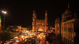
Hyderabad is the capital of the Indian state of Telangana. It is a historic city noted for its many monuments, temples, mosques and bazaars. A multitude of influences have shaped the character of the city in the last 400 years.


