
Alwal is in Hyderabad city, and a suburb of Hyderabad. Earlier, Alwal was a part of Malkajgiri Mandal but in 2006, Alwal Municipality was merged into Greater Hyderabad Municipal Corporation. After the district bifurcation in 2017, Alwal Municipality became a new Mandal "Alwal Mandal", in Malkajgiri revenue division, with Alwal as the Mandal Headquarters. It was a part of Ranga Reddy district before the re-organisation of districts in the state. It was a municipality prior to its merger into the Greater Hyderabad Municipal Corporation.

Vanasthalipuram is a residential neighborhood in Hyderabad, Telangana, India. It comes under Hayathnagar Mandal and Hayathnagar Revenue Division in L.B. Nagar zone along the highway towards Vijayawada a During the rule of the Nizam of Hyderabad, the area was a dense forest with wild animals and famous as a hunting ground, hence the name Vanasthalipuram. Vanasthalipuram derived its name from Harini Vanasthali, a deer park located beside national highway. It was originally known as Shikharghar. Now, Vanasthalipuram is famously known as retirees paradise. With booming IT in Hyderabad and TCS opening its south operations in Adibatla, the place is seeing an unprecedented real estate boom.

Ranga Reddy district is a district in the Indian state of Telangana. The district headquarters is located at Kongara Kalan Village, Ibrahimpatnam Mandal,. The district was named after the former deputy chief minister of the United Andhra Pradesh, K. V. Ranga Reddy. The district shares boundaries with Nalgonda, Yadadri Bhuvanagiri, Hyderabad, Medchal–Malkajgiri, Nagarkurnool, Mahabubnagar, Sangareddy and Vikarabad districts.
Kapra is a neighbourhood of Hyderabad city. It falls under Medchal-Malkajgiri district of the Indian state of Telangana and serves as the mandal headquarters of Kapra mandal in Keesara revenue division. It is administered as Circle No. 1 of Greater Hyderabad Municipal Corporation. There are six wards under this circle i.e., Kapra (1), Dr AS Rao Nagar (2), Cherlapally (3), Meerpet HB Colony (4), Mallapur (5) and Nacharam (6).
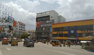
Lal Bahadur Nagar, commonly known as L. B. Nagar, is a commercial and residential hub in Hyderabad, Telangana, India. It was once a Municipality in Ranga Reddy district.
Malkajgiri also known as Mallikarjuna Giri is a suburb of Hyderabad, Telangana, India. It is located in Medchal–Malkajgiri district and also Sub-District in Medchal District is the headquarters of Malkajgiri mandal in Malkajgiri revenue division. Erstwhile Malkajgiri Major Grampanchayat was upgraded to a municipality in 1965 and became a municipal corporation in 1985. It was merged into the Greater Hyderabad Municipal Corporation in 2007. It was a part of Ranga Reddy district before the re-organisation of districts in 2016.
Quthbullapur is a Village in Hyderabad in the Medchal-Malkajgiri district of the Indian state of Telangana. It is the mandal headquarters of Quthbullapur mandal in Malkajgiri revenue division. The mandal was a part of Ranga Reddy district before the re-organisation of districts in the state. It was a municipality prior to its merger into the Greater Hyderabad Municipal Corporation.

Uppal is a suburb in Eastern Hyderabad, Telangana, India. It is the mandal headquarters of Uppal mandal in Keesara revenue division in Medchal-Malkajgiri district. It forms Circle No.2 in the L. B. Nagar Zone of Greater Hyderabad Municipal Corporation. There are four wards i.e., Chilukanagar (7), Habsiguda (8), Ramanthapur (9) and Uppal (10) in this circle.

Saroornagar is a suburb in Hyderabad. It is located in the Rangareddy district of Indian state of Telangana. It is located in Saroornagar mandal of Kandukur revenue division. This circle (5) comes under L. B. Nagar of Greater Hyderabad Municipal Corporation. There are five wards in this circle namely Saroornagar (19), Rama Krishna Puram (20), Kothapet (21), Chaitanyapuri (22) and Gaddiannaram (23).

Greater Hyderabad Municipal Corporation (GHMC) is the civic body that oversees Hyderabad, the capital and largest city of the Indian state of Telangana. It is the local government for the city of Hyderabad. It is one of the largest municipal corporations in India with a population of 7.9 million and an area of 650 km².
Balanagar is a neighbourhood of Hyderabad. It is located in Medchal-Malkajgiri district of the Indian state of Telangana. It is under the administration of Balanagar mandal of Malkajgiri revenue division. It was a part of Ranga Reddy district before the re-organisation of districts in the state. It is administered as Ward No. 120 of the Greater Hyderabad Municipal Corporation.

Bachupally is a suburb in the Medchal-Malkajgiri district of the Indian state of Telangana. It is the mandal headquarters of Bachupally mandal in Malkajgiri revenue division. It was a part of Ranga Reddy district before the re-organisation of districts in the state. The postal code (PIN) is 500118.
Khairatabad is a neigbbourhood in Hyderabad, Telangana, India. It is a mandal in the Secunderabad Revenue division of Hyderabad District. This is a Zone in the Greater Hyderabad Municipal Corporation. There are five circles in this zone namely Mehdipatnam (12), Karwan (13), Goshamahal (14), Khairatabad (17) and Jubilee Hills (18). There are four wards under this Khairatabad circle, they are Khairtabad (91), Somajiguda (97), Ameerpet (98) and Sanathnagar (100).

Hyderabad is located in central Telangana and is spread over an area of 2,500 km2. The city lies in the Deccan Plateau and rises to an average height of 536 m above the sea level. The city lies at 17.366° N latitude and 78.476° E longitude.

Serilingampally, also known as Lingampally, is a major suburb located in the north western part of Hyderabad City. It is the headquarters of the Serilingamapally mandal in the Ranga Reddy district of the Indian state of Telangana It is administered by the Greater Hyderabad Municipal Corporation (GHMC). Due to its close proximity to Hitech City, Gachibowli, Nanakramguda, Manikonda and Kondapur, there has been a heavy influx of IT companies. University of Hyderabad (UoH) is also located here.
Kondapur is a suburb in western part of Hyderabad, Telangana, India. It falls under Serilingampally mandal of Ranga Reddy district. The locality has emerged as a prominent commercial and residential hub, owing to its close proximity to IT corridor of Hyderabad. It is administered as Ward No. 104 of Greater Hyderabad Municipal Corporation.

Abdullapur and Abdullapurmet together constitute a village in Ranga Reddy district in Telangana, India. Abdullapur is a village whereas Abdullapurmet is Mandal. It is 5 kilometers from the Outer Ring Road, Hyderabad. The world famous Ramoji Film City is in Abdullapurmet. Abdullapurmet is a developing residential locality on the outskirts of Hyderabad. It is located alongside Hyderabad-Suryapet Highway (NH-65). It has a population of about 5511. The male and female populations are 2822 and 2689 respectively. The size of the area is about 3.98 square kilometers.

Hayat Bakshi Mosque also Hayat Bakshi Begum Masjid is a mosque located in Hayathnagar, near Hyderabad, India. It was constructed in 1672 during the reign of Abdullah Qutb Shah the fifth Sultan of Golconda, and named after Hayat Bakshi Begum.

Boduppal is a satellite city of Hyderabad and a municipal corporation in Medchal–Malkajgiri District of Telangana, India. It is administered by Boduppal Municipal Corporation. Located at the eastern end of Hyderabad City, it is spread between Nacharam-Mallapur Road and Warangal Highway NH 163. Due to its proximity to Secunderabad and Eastern IT/SEZ of Pocharam, it is emerging as a major residential location in Hyderabad.
The localities and neighborhoods of Hyderabad have unique oral histories, dating to the time of the Qutb Shahi dynasty, over 400 years ago, and are named after various people and things. Some are named after a major building or structure in the locality, others named for individuals. The names are mostly in Telugu and Urdu, the major languages of the city. This is a list of localities, neighborhoods and streets of Hyderabad and their etymology.


