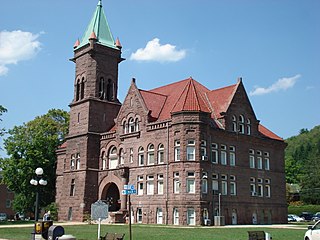
Barbour County is a county in north central West Virginia, United States. At the 2020 census, the population was 15,465. The county seat is Philippi, which was chartered in 1844. Both county and city were named for Philip P. Barbour (1783–1841), a U.S. Congressman from Virginia and Associate Justice of the U.S. Supreme Court. The county was formed in 1843 when the region was still part of the state of Virginia. In 1871, a small part of Barbour County was transferred to Tucker County, West Virginia.

Buckhannon is the only incorporated city in, and the county seat of, Upshur County, West Virginia, United States, along the Buckhannon River. The population was 5,299 as of the 2020 census. The city is located 60 miles southwest of Morgantown, 115 miles northeast of the capital city of Charleston, and 140 miles south of Pittsburgh, Pennsylvania. Buckhannon is home to West Virginia Wesleyan College and the West Virginia Strawberry Festival, held annually during the third week of May. In 2023, Buckhannon will host The World Association of Marching Show Bands.

The Little Kanawha River is a tributary of the Ohio River, 169 mi (269 km) long, in western West Virginia in the United States. Via the Ohio, it is part of the watershed of the Mississippi River, draining an area of 2,320 mi² (6,009 km²) on the unglaciated portion of the Allegheny Plateau. It served as an important commercial water route in the early history of West Virginia, particularly in the logging and petroleum industries.

The Tygart Valley River — also known as the Tygart River — is a principal tributary of the Monongahela River, approximately 135 miles (217 km) long, in east-central West Virginia in the United States. Via the Monongahela and Ohio rivers, it is part of the watershed of the Mississippi River, draining an area of 1,329 square miles (3,440 km2) in the Allegheny Mountains and the unglaciated portion of the Allegheny Plateau.
North River Mills is a historic unincorporated community in Hampshire County in the U.S. state of West Virginia. North River Mills is located between Capon Bridge and Slanesville on Cold Stream Road at its intersection with North River Road. The village of North River Mills lies along the eastern banks of North River from which it takes its name.

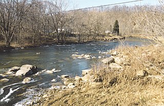
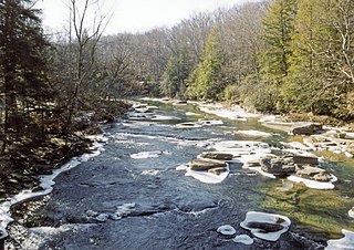
The Buckhannon River is a 45.4-mile-long (73.1 km) tributary of the Tygart Valley River in north-central West Virginia, USA. Via the Tygart Valley, Monongahela and Ohio rivers, it is part of the watershed of the Mississippi River, draining an area of 309 square miles (800 km2) on the unglaciated portion of the Allegheny Plateau. It provides drinking water for much of Upshur County.
Rock Cave is a census designated unincorporated community in Upshur County, West Virginia, United States. The town is located southwest of Buckhannon at the junction of West Virginia Route 4 with County Routes 11/2 and 20/28.

Sago is an unincorporated community in Upshur County, West Virginia, United States. It is located along the Buckhannon River and is the site of the Sago Mine, scene of the 2006 Sago Mine disaster.

Tennerton is an unincorporated community along the Buckhannon River, directly south of Buckhannon in Upshur County, West Virginia, United States.
Selbyville is an unincorporated community along the Right Fork Buckhannon River in Upshur County, West Virginia, United States.

Audra State Park is a West Virginia state park located on 355 acres (1.44 km2) in southwestern Barbour County. It was established around the remnants of an early 19th-century gristmill and the tiny community of Audra. A gristmill spillway is still visible in the river.
French Creek is an unincorporated community in Upshur County, West Virginia, United States.
Carrollton is an unincorporated community in Barbour County, in the U.S. state of West Virginia. Carrollton is known for its Carrollton Covered Bridge over the Buckhannon River, listed on the National Register of Historic Places.

The Middle Fork River is a 35.4-mile-long (57.0 km) tributary of the Tygart Valley River in north-central West Virginia, USA. Via the Tygart Valley, Monongahela and Ohio rivers, it is part of the watershed of the Mississippi River, draining an area of 152 square miles (390 km2) on the easternmost part of the unglaciated portion of the Allegheny Plateau. According to the Geographic Names Information System, the Middle Fork River has also been known simply as "Middle Fork" and as "Middlefork."

William Smith O'Brien was a lawyer and Democratic politician from West Virginia who served as a United States representative from 1927 to 1929.
Kanawha Head is an unincorporated community in Upshur County, West Virginia, United States. Kanawha Head is located on West Virginia Route 20, 16.5 miles (26.6 km) south-southwest of Buckhannon. Kanawha Head had a post office with ZIP code 26228.
Ellamore is an unincorporated community in Randolph and Upshur counties, West Virginia, United States. Ellamore is located on County Route 151 along the Middle Fork River, 8 miles (13 km) southeast of Buckhannon. Ellamore had a post office, which closed on July 11, 2009.
Alexander is an unincorporated community in Upshur County, West Virginia, United States. Alexander is located on County Route 11 and the Buckhannon River, 14.6 miles (23.5 km) south of Buckhannon. The coal hauling Beech Mountain Railroad (BEEM) also runs through and interchanges with the Appalachian and Ohio Railroad (A&O) in Alexander.


