
Three Churches is an unincorporated community in Hampshire County in the U.S. state of West Virginia. The town is located north of Romney along Jersey Mountain Road at a crossroads with Three Churches Hollow Road. Originally known as Jersey Mountain, Three Churches was renamed for the three historic white wooden churches located there: Mount Bethel Church, Mount Bethel Primitive Baptist Church, and Branch Mountain United Methodist Church. The Three Churches Post Office is no longer in service.

Levels is an unincorporated community in Hampshire County in the U.S. state of West Virginia. According to the 2000 census, the Levels community has a population of 147. It is home to John J. Cornwell Elementary School.
Slanesville is an unincorporated community in northeastern Hampshire County in the U.S. state of West Virginia. Slanesville is located at the crossroads of Bloomery Pike with Slanesville Pike and Cold Stream Road. Slanesville Pike and Cold Stream Road formerly made up the Springfield Grade Road that ran from Capon Bridge to Springfield. According to the 2000 census, the Slanesville community has a population of 691.
Purgitsville is an unincorporated community in Hampshire County in the U.S. state of West Virginia. According to the 2000 census, the ZCTA for Purgitsville had a population of 813. Purgitsville is located on U.S. Highway 220/West Virginia Route 28 at its intersection with Huffman Road south of Junction. An elementary school, Mill Creek Elementary, was open here until 1993 when it was consolidated with Romney Elementary.
Loom is an unincorporated community in Hampshire County, West Virginia, United States. Loom is located between Capon Bridge and Hanging Rock along the Northwestern Turnpike on the western flanks of Cooper Mountain. Timber Mountain Road and Beck's Gap Road converge at Loom on U.S. Route 50.

Neals Run is an unincorporated community in Hampshire County in the U.S. state of West Virginia. Neals Run is located south of Little Cacapon near the confluence of the Little Cacapon River and Neals Run on Spring Gap-Neals Run Road. The community derives its name from the stream.
Jolo is an unincorporated community on West Virginia Route 83 in McDowell County in the U.S. state of West Virginia. The community was mentioned in the book Salvation on Sand Mountain by Dennis Covington for being the home of the Church of the Lord Jesus with Signs Following, a renowned snake handling church. Services at the church have been filmed and widely shown on television.
Stotesbury is an unincorporated community and former coal town in Raleigh County in the U.S. state of West Virginia that flourished during the 1930s. The community was named for Edward T. Stotesbury, then the president of Beaver Coal Company.
The Episcopal Diocese of West Virginia is a diocese of the Episcopal Church in the United States of America (TEC). It encompasses all 55 counties of West Virginia. The diocese has 66 congregations, including 38 parishes, 26 missions, and 2 other churches. The diocese is headquartered in Charleston and led by The Rt. Rev. Matthew Davis Cowden who was consecrated as bishop coadjutor in March, 2022 and became bishop diocesan in October, 2022.

Quick is a small unincorporated community in Kanawha County, West Virginia, United States. It is located along Indian Creek Road. The community is where Whitoak Fork and Blue Creek come together and meet. It is also where the abandoned railroad that follows Blue Creek joins the road, and follows it all the way to the community of Hitop, along Pond Fork. Its post office is closed.
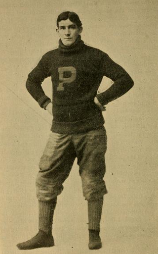
Peter Delome Overfield was an All-American and professional football player, federal judge and rancher. Overfield played center for the University of Pennsylvania and was a first-team All-American in 1898 and 1899. He served as a federal district judge in Alaska from 1909 to 1917. In 1917, he moved to Casa Grande, Arizona, where he lived for the remainder of his life, owning a large ranching operation.
Key Rock is an unincorporated community in Wyoming County, West Virginia, United States. The community is home to the Coon Fork Church congregation and the Lester Family Cemetery.
Wyco is an unincorporated community in Wyoming County, West Virginia, United States. Some say the community derives its name from Wyoming County, while others believe the community was named for the Wyoming Coal Company. It is located off West Virginia Route 16. The Wyco Church is also located within Wyco.

Pluto is an unincorporated community in Raleigh County, West Virginia. The elevation is 2,589 feet.

Shrewsbury is a census-designated place (CDP) and unincorporated community in Kanawha County, West Virginia, United States. Shrewsbury is located on the north bank of the Kanawha River along U.S. Route 60. As of the 2010 census, its population was 652.
Rutherford is an unincorporated community in Fairfax County, Virginia, United States. It lies South of Virginia State Highway 236, North of Virginia State Route 620, East of Olley Lane, and West of Guinea Road. This is west of Annandale, east of the independent city of Fairfax.

Silver Lake is an unincorporated community in Preston County, West Virginia, United States. Silver Lake is located along U.S. Route 219, 7.5 miles (12.1 km) north of Thomas in Tucker County.
Dillon is an unincorporated community in Raleigh County, West Virginia, United States. It was also known as Irish Mountain and is the location of St. Colman's Roman Catholic Church and Cemetery, which is on the National Register of Historic Places.
Pisgah is an unincorporated community in Preston County, West Virginia, United States.


