
Dartmoor is an upland area in southern Devon, England. The moorland and surrounding land has been protected by National Park status since 1951. Dartmoor National Park covers 954 km2 (368 sq mi).
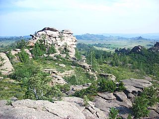
A tor, which is also known by geomorphologists as either a castle koppie or kopje, is a large, free-standing rock outcrop that rises abruptly from the surrounding smooth and gentle slopes of a rounded hill summit or ridge crest. In the South West of England, the term is commonly also used for the hills themselves – particularly the high points of Dartmoor in Devon and Bodmin Moor in Cornwall.

The River Avon, also known as the River Aune, is a river in the county of Devon in the southwest of England. It rises in the southern half of Dartmoor National Park in an area of bog to the west of Ryder's Hill. Close to where the river leaves Dartmoor a dam was built in 1957 to form the Avon reservoir. After leaving the moor it passes through South Brent and then Avonwick and Aveton Gifford and flows into the sea at Bigbury-on-Sea. Near Loddiswell the valley flows through Fosse Copse a 1.88 hectares woodland owned and managed by the Woodland Trust.

Okehampton is a town and civil parish in West Devon in the English county of Devon. It is situated at the northern edge of Dartmoor, and had a population of 5,922 at the 2011 census. Two electoral wards are based in the town. Their joint population at the same census is 7,500.

West Devon is a local government district and borough in Devon, England. Towns in the district include Chagford, Okehampton, Princetown, and Tavistock, where the council is based.

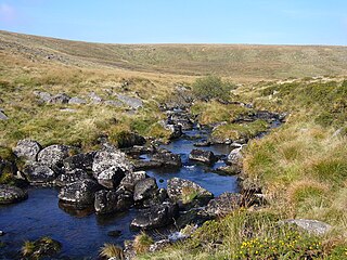
Drizzlecombe or Thrushelcombe is an area of Dartmoor in the county of Devon, England, containing a number of Bronze Age stone rows, cairns and menhirs.

The Dartmoor Railway is a 15+1⁄2-mile (24.9 km) long railway line in Devon, England. From Crediton the line parallels the Tarka Line to the site of the former Coleford Junction. Heading west, it then serves Sampford Courtenay, Okehampton and Meldon Quarry. The section from Crediton to Coleford Junction is owned by Network Rail and from there to Meldon is owned by Aggregate Industries. In the past freight trains served the ballast quarry at Meldon. The line is leased to and maintained by the Dartmoor Railway CIC, who operate some services and facilitate access to the line by other operators.

The Two Moors Way is a long-distance trail in Devon, UK, first established in 1976. It links Dartmoor and Exmoor and has been extended to become a Devon Coast-to-Coast trail.

Bovey Tracey is a small town and civil parish in Devon, England, on the edge of Dartmoor, its proximity to which gives rise to the "slogan" used on the town's boundary signs, "The Gateway to the Moor". It is often known locally as "Bovey". It is about 10 miles south-west of Exeter and lies on the A382 road, about halfway between Newton Abbot and Moretonhampstead. The village is at the centre of the electoral ward of Bovey. At the 2011 census the population of this ward was 7,721.
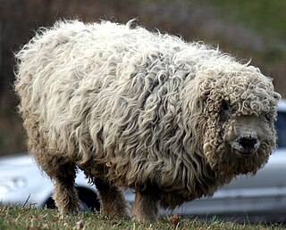
The Greyface Dartmoor is a rare breed of domestic sheep originating around Dartmoor in south west England. Also known as the "Improved Dartmoor", this is a large and long-woolled breed, known for its distinctive facial markings. Its fleece can weigh 7 to 9 kg, and today the breed is primarily raised for meat.
Ashburn is a river in the Dartmoor moors in Devon in south-west England, flowing through the Ashburton valley to the River Dart.

East Okement is a river in the Dartmoor moors in Devon in south-west England. It joins the West Okement at Okehampton to form the Okement.

The East Webburn is a stream in the Dartmoor moors in Devon in south-west England. It rises on the western side of the moors flowing off the west side of Hameldown ridge. Its source is less than 1 kilometre south west of Grimspound Bronze Age settlement. It flows south past Widecombe-in-the-Moor and joins the West Webburn River. These combined streams then join the River Dart close to the village of Holne.

The Lyd is a river rising at Lyd Head in the Dartmoor national park in Devon in South West England and flowing into the River Tamar beyond Lifton. It runs through Lydford Gorge, the deepest gorge in South West England.
The East Dart River is one of the two main tributaries of the River Dart in Devon, England.
The West Dart River is one of the two main tributaries of the River Dart in Devon, England.

Dartmoor Zoological Park is a 30-acre (12 ha) zoo just north of the village of Sparkwell, on the south-west edge of Dartmoor, in the county of Devon in the South West of England. It was opened in 1968 by Ellis Daw who ran it until its licence was revoked and it was forced to close in 2006. The zoo was bought in August 2006 by Benjamin Mee and reopened the zoo in July 2007, later writing a book about his experiences called We Bought a Zoo (2008). A 2011 film of the same title was loosely based on the book.

Dartmoor kistvaens are burial tombs or cists from the late Neolithic and early Bronze Age, i.e. from c 2500 BC to c 1500 BC. Kistvaens have been found in many places, including Dartmoor, a 954 km2 area of moorland in south Devon, England. The box-like stone tombs were created when the ancient people of the area lived in hut circles. Cists are often to be found in the centre of a cairn circle although some appear solitary which could be the result of the loss of an original slight mound. There are over 180 known cists on Dartmoor although there could be up to 100 that remain buried underneath unexplored cairns. In the South West there are no cists to be found on the Quantock Hills, only 2 to be found on Exmoor and 58 to be found on Bodmin Moor. The Dartmoor cists are unique in that about 94% have the longer axis of the tomb orientated in a NW/SE direction It appears that Dartmoor cists were positioned in such a way that the deceased were facing the sun.

West Buckfastleigh is a small civil parish on the eastern border of Dartmoor in Devon, England. Situated within the parish are the village of Scorriton and the hamlets of Michelcombe and Combe.


