Marmet is a city in Kanawha County, West Virginia, United States, along the Kanawha River. The population was 1,501 at the 2020 census.

Alum Creek is a census-designated place (CDP) in Kanawha and Lincoln counties along the Coal River in the U.S. state of West Virginia. It includes the unincorporated communities of Alum Creek, Forks of Coal, and Priestley. The CDP had a population of 1,749 at the 2010 census, down from 1,839 at the 2000 census.

Coal City is a census-designated place (CDP) in Raleigh County, West Virginia, United States. The population was 1,815 at the 2010 census. Coal City's population is composed of other surrounding unincorporated communities.

Tornado, also called Upper Falls, is a census-designated place (CDP) in Kanawha County, West Virginia, United States.
Page is a census-designated place (CDP) and coal town in Fayette County, West Virginia, United States. As of the 2010 census, its population was 224. It was named for William Nelson Page (1854-1932), a civil engineer and industrialist who lived in nearby Ansted, where he managed Gauley Mountain Coal Company and many iron, coal, and railroad enterprises.

Cucumber is a census-designated place (CDP) in McDowell County, West Virginia, United States. Its population was 74 at the 2020 census. The community is centered on mining. Named either for nearby Cucumber Creek or for the cucumber trees in the area, it is the only community in the United States with this name. Its post office was still active as of October 2011.
Pageton is a census-designated place (CDP) in McDowell County, West Virginia, United States. As of the 2010 census, its population was 187. Pageton is located on the Tug Fork Branch of the Norfolk and Western Railway, along the Pocahontas seam of rich bituminous coal. Pageton is located on State Route 161 between Thorpe and Anawalt.

Itmann is a census-designated place (CDP) and former mining town located in Wyoming County, West Virginia, United States, between Pineville and Mullens off West Virginia Route 16. As of the 2010 census, its population was 293; it had 138 homes, 119 of which were occupied.
Galloway is a census-designated place (CDP) and coal town in northwestern Barbour County, West Virginia, United States. It lies along West Virginia Route 76 northwest of the city of Philippi, the county seat of Barbour County. Its elevation is 1,073 feet (327 m). It has a post office with the ZIP code 26349. As of the 2010 census, its population is 143.
Beards Fork is a census-designated place (CDP) and coal town in Fayette County, West Virginia, United States that was founded as a coal town. As of the 2010 census, its population was 199.
Maybeury is a census-designated place (CDP) in McDowell County, West Virginia, United States, located on U.S. Route 52 between Northfork and Bramwell. As of the 2010 census, its population was 234.
Sarah Ann is a census-designated place (CDP) in Logan County, West Virginia, United States. The CDP includes the unincorporated community of Sarah Ann, plus the neighboring communities of Crystal Block and part of Stirrat. As of the 2010 census, the population of the CDP was 345.

Helen is a census-designated place (CDP) in Raleigh County, West Virginia, United States. As of the 2010 census, its population was 219. West Virginia Route 16, Winding Gulf and railroad tracks run right through the community.

Mount Carbon is a census-designated place (CDP) in Fayette County, West Virginia, United States. Mount Carbon is located along West Virginia Route 61, 3 miles (4.8 km) southeast of Montgomery, on the south bank of the Kanawha River at the mouth of Armstrong Creek. Mount Carbon has a post office with ZIP code 25139. As of the 2010 census, its population was 428.

Scarbro is a census-designated place (CDP) and coal town in Fayette County, West Virginia, United States. Scarbro is 1.5 miles (2.4 km) southwest of Oak Hill. Scarbro has a post office with ZIP code 25917. As of the 2010 census, its population was 486.
Eccles is a census-designated place (CDP) in Raleigh County, West Virginia, United States. Eccles is located on West Virginia Route 3, 4 miles (6.4 km) west of Beckley. Eccles has a post office with ZIP code 25836. As of the 2010 census, its population is 362.

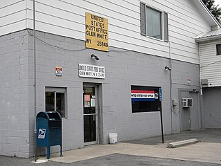
Glen White is a census-designated place (CDP) in Raleigh County, West Virginia, United States. Glen White is located on state routes 54 and 97, 1 mile (1.6 km) southeast of Lester. Glen White had a post office with ZIP code 25849. As of the 2010 census, its population is 266.
Hepzibah is a census-designated place (CDP) and coal town in Harrison County, West Virginia, United States. It is located on U.S. Route 19 and West Virginia Route 20, 3.5 miles (5.6 km) north of Clarksburg.
Vivian is a census-designated place (CDP) in McDowell County, West Virginia, United States. Vivian is located along U.S. Route 52, 1 mile (1.6 km) southeast of Kimball. As of the 2010 census, its population was 82.
Wolf Summit is a census-designated place and coal town in Harrison County, West Virginia, United States. Its population was 272 as of the 2010 census.


