
The Western Maryland Railway was an American Class I railroad (1852–1983) which operated in Maryland, West Virginia, and Pennsylvania. It was primarily a coal hauling and freight railroad, with a small passenger train operation.

The Sloan–Parker House, also known as the Stone House, Parker Family Residence, or Richard Sloan House, is a late-18th-century stone residence near Junction, Hampshire County, in the U.S. state of West Virginia. It was built on land vacated by the Shawnee after the Native American nation had been violently forced to move west to Kansas following their defeat at the Battle of Point Pleasant in 1774. The building was added to the National Register of Historic Places on June 5, 1975, becoming Hampshire County's first property to be listed on the register. The Sloan–Parker House has been in the Parker family since 1854. The house and its adjacent farm are located along the Northwestern Turnpike in the rural Mill Creek valley.

Springfield is a census-designated place (CDP) in northwestern Hampshire County in the U.S. state of West Virginia. As of the 2010 census, Springfield had a population of 477. Springfield is located north of Romney along West Virginia Route 28 at its junction with Green Spring Road and Springfield Pike. It is currently considering incorporation.
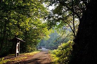
Junction is an unincorporated community in Hampshire County in the U.S. state of West Virginia. Historically referred to as Moorefield Junction, Junction received its name because of its location at the crossroads of U.S. Route 220/West Virginia Route 28 and the Northwestern Turnpike. The community is located along Mill Creek.
Rada is an unincorporated community in Hampshire County in the U.S. state of West Virginia. Rada is located on U.S. Highway 220/West Virginia Route 28 between Junction and Purgitsville in southwest Hampshire County along Mill Creek. It lies at an intersection of US 220/WV 28 with Rada Road.

Shenandoah Junction is a census-designated place (CDP) in Jefferson County in the U.S. state of West Virginia's Eastern Panhandle. As of the 2010 census, Shenandoah Junction had a population of 703. It is located between Kearneysville and Charles Town off WV 9. Shenandoah Junction is home to Jefferson High School and West Virginia's oldest surviving wood-frame structure, the Peter Burr House, built around 1751. The land where Shenandoah Junction was built was part of the 392 acres (1.59 km2) granted by Lord Fairfax to Lewis Neil. The town was originally called Neil's, but the name was changed to Shenandoah Junction in 1881.

Mill Creek is a 14.0-mile-long (22.5 km) tributary stream of the South Branch Potomac River, belonging to the Potomac River and Chesapeake Bay watersheds. The stream is located in Hampshire County in West Virginia's Eastern Panhandle. Mill Creek flows into the South Branch west of Romney Bridge near Vanderlip along the Northwestern Turnpike.

The Midland Trail, also called the Roosevelt Midland Trail, was a national auto trail spanning the United States from Washington, D.C. west to Los Angeles, California and San Francisco, California. First road signed in 1913, it was one of the first, if not the first, marked transcontinental auto trails in America.
New River Trail State Park is a 57.7-mile (92.9 km) rail trail and state park located entirely in southwest Virginia, extending from the trail's northeastern terminus in Pulaski to its southern terminus in Galax, with a 5.5-mile (8.9 km) spur from Fries Junction on the main trail to Fries.
The West Virginia Central and Pittsburg Railway (WVC&P) was a railroad in West Virginia and Maryland operating in the late 19th and early 20th centuries. It had main lines radiating from Elkins, West Virginia in four principal directions: north to Cumberland, Maryland; west to Belington, WV; south to Huttonsville, WV; and east to Durbin, WV. Some of the routes were constructed through subsidiary companies, the Piedmont and Cumberland Railway and the Coal and Iron Railway.
Allen Junction is an unincorporated community in Wyoming County, West Virginia, United States. Their post office is still open.

Glen Daniel is an unincorporated community in Raleigh County, West Virginia, United States. Glen Daniel is located at the junction of West Virginia Route 3 and West Virginia Route 99, 8.5 miles (13.7 km) west of Beckley. Glen Daniel has a post office with ZIP code 25844.
Bacova Junction is an unincorporated community in Bath County, Virginia, in the United States. Bacova Junction is situated 2.9 miles (4.7 km) west of Hot Springs, and Virginia State Route 615 and Virginia State Route 687 converge at the community. Historically, Bacova Junction was known for its timber industry.
Tyler Heights, also known as Flatwoods, is an unincorporated community in Kanawha County, West Virginia, United States. Tyler Heights is located along West Virginia Route 622 at its junction with West Virginia Route 501, 5 miles (8.0 km) east-northeast of Nitro.
Clear Fork Junction is an unincorporated community in McDowell County, West Virginia, United States.
Elk Run Junction is an unincorporated community in Boone County, West Virginia, United States.
Rum Junction is an unincorporated community in Logan County, West Virginia, United States.
Trace Junction is an unincorporated community in Logan County in the U.S. state of West Virginia.
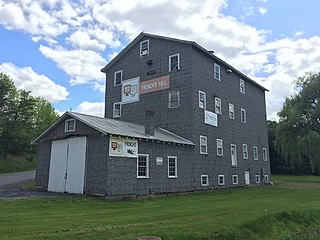
French's Mill is a historic grist mill at the junction of Augusta-Ford Hill and Fairground Roads in Augusta, West Virginia. Its main building is a three-story wood-frame building with a metal roof, asphalt siding, and a concrete foundation. It was built in 1911 on the site of a c. 1890s grist mill that was destroyed by fire. The mill, which was originally water-powered, was converted to operate by electric power in 1949, and ceased operations in 2000. It was also updated in the mid-20th century to accommodated different types of grain, illustrating the evolutionary change of these industrial facilities.
West Junction is an unincorporated community in Boone County, West Virginia, United States.


