
Randolph County is a county located in the U.S. state of West Virginia. As of the 2020 census, the population was 27,932. Its county seat is Elkins. The county was founded in 1787 and is named for Edmund Jennings Randolph.

Elkins is a city in and the county seat of Randolph County, West Virginia, United States, along the Tygart Valley River. The community was incorporated in 1890 and named in honor of Stephen Benton Elkins, a U.S. Senator from West Virginia. The population was 6,950 at the 2020 census and estimated at 6,895 in 2021. Elkins is home to Davis and Elkins College and the Mountain State Forest Festival, held in early October every year.

Grafton is a city in and the county seat of Taylor County, West Virginia, United States, along the Tygart Valley River. The population was 4,729 at the 2020 census. It originally developed as a junction point for the Baltimore and Ohio Railroad, serving numerous branches of a network that was vital to the regional coal industry.

The Monongahela River, sometimes referred to locally as the Mon, is a 130-mile-long (210 km) river on the Allegheny Plateau in north-central West Virginia and Southwestern Pennsylvania. The river flows from the confluence of its west and east forks in north-central West Virginia northeasterly into southwestern Pennsylvania, then northerly to Pittsburgh and its confluence with the Allegheny River to form the Ohio River. The river includes a series of locks and dams that makes it navigable.

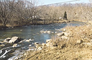
The Tygart Valley River — also known as the Tygart River — is a principal tributary of the Monongahela River, approximately 135 miles (217 km) long, in east-central West Virginia in the United States. Via the Monongahela and Ohio rivers, it is part of the watershed of the Mississippi River, draining an area of 1,329 square miles (3,440 km2) in the Allegheny Mountains and the unglaciated portion of the Allegheny Plateau.
The Buckhannon River is a 45.4-mile-long (73.1 km) tributary of the Tygart Valley River in north-central West Virginia, USA. Via the Tygart Valley, Monongahela and Ohio rivers, it is part of the watershed of the Mississippi River, draining an area of 309 square miles (800 km2) on the unglaciated portion of the Allegheny Plateau. It provides drinking water for much of Upshur County.
Independence is an unincorporated community in Barbour County, West Virginia, United States. Independence is located south of Philippi on County Route 30 near the Tygart Valley River. The community is centered on and named for the Independence School there.
East Dailey is a census-designated place (CDP) in Randolph County, West Virginia, United States. As of the 2010 census, its population was 557. It is located within the Monongahela National Forest adjacent to the Tygart Valley River. East Dailey and its Old Timer's Camp are host to the Elkhenge Music Festival.

U.S. Route 50 in West Virginia runs from the border with Ohio to Virginia, passing briefly through Garrett County, Maryland, and following the Northwestern Turnpike. Prior to the U.S. Highway System it was West Virginia Route 1 and in the 1930s, the road was not finished in Maryland. Today the section of US 50 from Clarksburg to Parkersburg on the Ohio River is part of Corridor D of the Appalachian Development Highway System.
Tygart Lake State Park sits on 391 acres (1.58 km2) along the shores of Tygart Lake in Taylor County near Grafton, West Virginia, United States.
The Greenbrier, Cheat and Elk Railroad (GC&E) was a logging railroad in West Virginia operating in the early 20th century. Its main line ran from Bergoo to Cheat Junction, where it connected with the Western Maryland Railway (WM).
The West Virginia Central and Pittsburg Railway (WVC&P) was a railroad in West Virginia and Maryland operating in the late 19th and early 20th centuries. It had main lines radiating from Elkins, West Virginia in four principal directions: north to Cumberland, Maryland; west to Belington, WV; south to Huttonsville, WV; and east to Durbin, WV. Some of the routes were constructed through subsidiary companies, the Piedmont and Cumberland Railway and the Coal and Iron Railway.
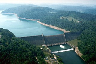
Tygart Dam — also known as Tygart River Dam — is a gravity dam built (1934-38) and operated by the United States Army Corps of Engineers in Taylor County, West Virginia, United States. The dam regulates the waters of the Tygart Valley River. Its storage reservoir is known as Tygart Lake. Most of the lakeshore is occupied by Tygart Lake State Park and Pleasant Creek Wildlife Management Area. The structure was listed on the National Register of Historic Places in 1995.

Tygart Creek is a tributary of the Little Kanawha River, 14.5 miles (23.3 km) long, in western West Virginia in the United States. Via the Little Kanawha and Ohio rivers, it is part of the watershed of the Mississippi River, draining an area of 51 square miles (130 km2) on the unglaciated portion of the Allegheny Plateau.
Leading Creek is a tributary of the Tygart Valley River, 17.4 miles (28.0 km) long, in eastern West Virginia in the United States. Via the Tygart Valley, Monongahela and Ohio rivers, it is part of the watershed of the Mississippi River, draining an area of 61 square miles (160 km2) in the Allegheny Mountains. The stream's entire course and drainage basin are in northern Randolph County.
Upper Mingo is an unincorporated community in southern Randolph County, West Virginia, United States. Upper Mingo is located along the Tygart Valley River on U.S. Route 219 and West Virginia Route 55, 17 miles (27 km) south-southwest of Mill Creek.
Aggregates is an unincorporated community in Randolph County, West Virginia, USA. It is situated on the Tygart Valley River about 2 miles above its confluence with Roaring Creek and about 2 miles below Elkins.

Fox Forest Wildlife Management Area (WMA) is located south of Elkins, West Virginia in Randolph County. It is located along the Tygart Valley River and is adjacent to the West Virginia Division of Natural Resources' Elkins Operations Center.


