Canning Creek, Queensland

Last updated

Canning Creek
Queensland
Australia Queensland location map.svg
Red pog.svg
Canning Creek
Coordinates 28°16′05″S151°08′41″E / 28.26806°S 151.14472°E / -28.26806; 151.14472
Population5 (2016 census) [1]
 • Density0.0174/km2 (0.045/sq mi)
Established1877
Postcode(s) 4357
Area288.1 km2 (111.2 sq mi)
LGA(s)
State electorate(s) Southern Downs
Federal division(s) Maranoa
Suburbs around Canning Creek:
Bringalily Bringalily Stonehenge
Bybera Canning Creek Mosquito Creek
Inglewood Inglewood Mosquito Creek

Canning Creek is a rural locality split between the Goondiwindi Region and the Toowoomba Region in Queensland, Australia. [2] [3] In the 2016 census, Canning Creek had a population of 5 people. [1]

Contents

Geography

The Millmerran–Inglewood Road (State Route 82) passes through the locality from north to south. [4]

Much of the locality is occupied by a large portion of the Bringalily State Forest.

History

The locality takes its name from the creek named in 1827 by explorer Allan Cunningham after Sir George Canning, the Prime Minister of Great Britain. [2]

British pastoralists arrived in the 1840s with Captain Robert Gerald Moffatt, a retired British Army officer of the 17th Regiment, forming the Canning Creek pastoral lease. [5]

In 1848, 3 Aboriginal women and one child were murdered in the area by a posse of seven white men. [6] [7]

Canning Creek was opened for selection on 17 April 1877; 112 square miles (290 km2) were available. [8]

The Canning Creek Provisional School opened on 15 November 1885 and became Canning Creek State School on 1 January 1909. The school closed on a number of occasions due to low student numbers. On 18 April 1922 it became a half-time school sharing the teacher with Glenside State School, with both schools closing on 20 June 1922. [9]

Glenside Provisional School opened in 1914. On 1 December 1914 it became Glenside State School. On 18 April 1922 it was closed as a full-time school and reopened as a half time school in conjunction with Canning Creek State School. Due to the distance between the 2 schools they closed on 20 June 1922. [10]

In the 2016 census, Canning Creek had a population of 5 people. [1]

Education

There are no schools in the locality. The nearest primary and secondary school is Inglewood State School (Prep to Year 10) in neighbouring Inglewood to the south. There are no nearby secondary schools for education to Year 12; the nearest are Goondiwindi State High School in Goondiwindi and Warwick State High School in Warwick. Distance education and boarding school would be other options. [11]

Related Research Articles

<span class="mw-page-title-main">Inglewood, Queensland</span> Town in Queensland, Australia

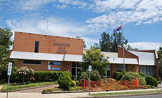
Inglewood is a rural town and locality in the Goondiwindi Region, Queensland, Australia. In the 2016 census, the locality of Inglewood had a population of 954 people, making Inglewood the second largest town in the Goondiwindi Region.

<span class="mw-page-title-main">Yelarbon</span> Town in Queensland, Australia

Yelarbon is a rural town and locality in the Goondiwindi Region, Queensland, Australia. It is on the border of Queensland and New South Wales. In the 2016 census, Yelarbon had a population of 364 people.

Yandilla is a rural locality in the Toowoomba Region, Queensland, Australia. In the 2016 census Yandilla had a population of 46 people.

<span class="mw-page-title-main">Groomsville, Queensland</span> Suburb of Toowoomba Region, Queensland, Australia

Groomsville is a rural locality in the Toowoomba Region on the Darling Downs, Queensland, Australia. In the 2021 census, Groomsville had a population of 132 people.

Captains Mountain is a locality in the Toowoomba Region, Queensland, Australia. In the 2021 census, Captains Mountain had a population of 74 people.

<span class="mw-page-title-main">Domville, Queensland</span> Suburb of Toowoomba Region, Queensland, Australia

Domville is a rural locality in the Toowoomba Region, Queensland, Australia. In the 2021 census, Domville had "no people or a very low population".

<span class="mw-page-title-main">Spring Creek, Queensland (Darling Downs)</span> Suburb of Toowoomba Region, Queensland, Australia

Spring Creek is a rural locality split between the Toowoomba Region and the Southern Downs Region, Queensland, Australia. In the 2016 census, Spring Creek had a population of 194 people.

<span class="mw-page-title-main">Bungunya, Queensland</span> Suburb of Goondiwindi Region, Queensland, Australia

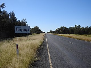
Bungunya is a rural town and locality in the Goondiwindi Region, Queensland, Australia. The locality is on the border of Queensland and New South Wales. In the 2016 census, Bungunya had a population of 75 people.

Ellangowan is a rural locality in the Toowoomba Region, Queensland, Australia. In the 2021 census, Ellangowan had a population of 95 people.

<span class="mw-page-title-main">Beebo, Queensland</span> Suburb of Goondiwindi Region, Queensland, Australia

Beebo is a rural locality in the Goondiwindi Region, Queensland, Australia. It is on the border between Queensland and New South Wales. In the 2016 census, Beebo had a population of 84 people.

Brush Creek is a rural locality in the Goondiwindi Region, Queensland, Australia. In the 2016 census, Brush Creek had a population of 40 people.

<span class="mw-page-title-main">Coolmunda, Queensland</span> Suburb of Goondiwindi Region, Queensland, Australia

Coolmunda is a rural locality in the Goondiwindi Region, Queensland, Australia. In the 2016 census, Coolmunda had a population of 141 people.

Gore is a rural town and locality in the Goondiwindi Region, Queensland, Australia. In the 2016 census, the locality of Gore had a population of 36 people.

Greenup is a rural locality in the Goondiwindi Region, Queensland, Australia. In the 2016 census, Greenup had a population of 23 people.

Limevale is a rural locality in the Goondiwindi Region, Queensland, Australia. In the 2016 census, Limevale had a population of 64 people.

<span class="mw-page-title-main">Oman Ama, Queensland</span> Suburb of Goondiwindi Region, Queensland, Australia

Oman Ama is a rural locality in the Goondiwindi Region, Queensland, Australia. In the 2016 census, Oman Ama had a population of 38 people.

South Talwood is a rural locality in the Goondiwindi Region, Queensland, Australia. It is on the border of Queensland and New South Wales. In the 2016 census, South Talwood had a population of 95 people.

Whetstone is a rural locality in the Goondiwindi Region, Queensland, Australia. In the 2016 census Whetstone had a population of 65 people.

Bringalily is a rural locality in the Toowoomba Region, Queensland, Australia. In the 2016 census Bringalily had a population of 83 people.

Millwood is a rural locality in the Toowoomba Region, Queensland, Australia. In the 2016 census Millwood had a population of 23 people.

References

  1. 1 2 3 Australian Bureau of Statistics (27 June 2017). "Canning Creek (SSC)". 2016 Census QuickStats. Retrieved 20 October 2018. OOjs UI icon edit-ltr-progressive.svg
  2. 1 2 "Canning Creek (Goondiwindi Regional) – locality (entry 47804)". Queensland Place Names. Queensland Government . Retrieved 4 July 2017.
  3. "Canning Creek (Toowoomba Regional) – locality (entry 49209)". Queensland Place Names. Queensland Government . Retrieved 4 July 2017.
  4. Google (29 July 2019). "Canning Creek, Queensland" (Map). Google Maps . Google. Retrieved 29 July 2019.
  5. "Family Notices". The Sydney Morning Herald . Vol. XXIII, no. 3404. New South Wales, Australia. 17 April 1848. p. 3. Retrieved 15 September 2023 via National Library of Australia.
  6. Rolleston, Christopher. "Letters to Colonial Secretary relating to Moreton Bay and Queensland 1848" (PDF). Retrieved 28 December 2017.
  7. "REWARD". New South Wales Government Gazette . No. 2. New South Wales, Australia. 2 January 1849. p. 4. Retrieved 15 September 2023 via National Library of Australia.
  8. "Proclamations under the New Land Acts". The Brisbane Courier . Queensland, Australia. 2 March 1877. p. 3. Retrieved 19 February 2020 via Trove.
  9. Queensland Family History Society (2010), Queensland schools past and present (Version 1.01 ed.), Queensland Family History Society, ISBN   978-1-921171-26-0
  10. Queensland Family History Society (2010), Queensland schools past and present (Version 1.01 ed.), Queensland Family History Society, ISBN   978-1-921171-26-0
  11. "Queensland Globe". State of Queensland . Retrieved 21 October 2020.