South Toowoomba, Queensland

Last updated

South Toowoomba
Toowoomba,  Queensland
Toowoomba South State School.jpg
Australia Queensland location map.svg
Red pog.svg
South Toowoomba
Coordinates 27°34′34″S151°57′14″E / 27.5761°S 151.9538°E / -27.5761; 151.9538 Coordinates: 27°34′34″S151°57′14″E / 27.5761°S 151.9538°E / -27.5761; 151.9538
Population5,224 (2016 census) [1]
 • Density1,412/km2 (3,660/sq mi)
Postcode(s) 4350
Area3.7 km2 (1.4 sq mi)
Time zone AEST (UTC+10:00)
Location2 km (1 mi) S of Toowoomba
LGA(s) Toowoomba Region
State electorate(s) Toowoomba South
Federal Division(s) Groom
Suburbs around South Toowoomba:
Newtown Toowoomba City East Toowoomba
Harristown South Toowoomba Rangeville
Harristown Kearneys Spring Centenary Heights

South Toowoomba is an urban locality in Toowoomba in the Toowoomba Region, Queensland, Australia. [2] In the 2016 census, South Toowoomba had a population of 5,224 people. [1]

Contents

Geography

South Toowoomba is located immediately south of the Toowoomba city centre. [3]

History

Giabal is an Australian Aboriginal language. The Giabal (Paiamba,Gomaingguru) language region includes the landscape within the local government boundaries of the Toowoomba Regional Council, particularly Toowoomba south to Allora and west to Millmerran. [4]

St Patrick's Catholic Primary School opened in 1863 at St Patrick's Catholic Church with lay teachers but from 1873 was operated by the Sisters of Mercy. St Patrick's Secondary School for Girls opened in 1914 and was renamed The Cathedral School in 1938. In 1959 the two schools were renamed St Saviour's Primary School and St Saviour's Secondary School. [5] Subsequently[ when? ] the secondary school was renamed St Saviour's College. From 1989 the secondary school came under lay administration. [6] In 1994 the primary school also came under lay administration. [7]

Toowoomba South State School opened in 1865. It was divided into Toowoomba South Girls and Infants School and Toowoomba South Boys School in 1869. On 1 April 1878 the Girls and Infants School split into Toowoomba Middle Girls State School No and Toowoomba Middle Infants State Schoo, but on 1 March 1880 they were merged to create Toowoomba Middle Girls and Infants State School. On 22 January 1883 the school was split again into Toowoomba South Girls State School and Toowoomba South Infants State School, being merged back on 1 October 1900 into Toowoomba South Girls and Infants School. In 1983 the Girls and Infants School and the Boys School were merged to re-establish Toowoomba South State School. [5] The school closed on 31 December 2013. [8]

In the 2016 census, South Toowoomba had a population of 5,224 people. [1]

Attractions

St Patricks Cathedral, 2014 St Patricks Cathedral, Toowoomba.jpg
St Patricks Cathedral, 2014

Education

St Saviour's Primary School is a Catholic primary (Prep-6) school for boys and girls at 14 Lawrence Street ( 27°34′15″S151°57′11″E / 27.5708°S 151.9530°E / -27.5708; 151.9530 (St Saviour's Primary School) . [11] [12] In 2017, the school had an enrolment of 409 students with 25 teachers (21 full-time equivalent) and 19 non-teaching staff (9 full-time equivalent). [13]

St Saviour's College is a Catholic secondary (7-12) school for girls at Neil Street ( 27°34′20″S151°57′13″E / 27.5721°S 151.9535°E / -27.5721; 151.9535 (St Saviour's College) ). [11] [14] In 2017, the school had an enrolment of 158 students with 24 teachers (21 full-time equivalent) and 15 non-teaching staff (11 full-time equivalent). [13]

The University of Queensland Medical School is located at Toowoomba Hospital.

Heritage listings

South Toowoomba has a number of heritage-listed sites, including:

Related Research Articles

Dalby, Queensland Town in Queensland, Australia

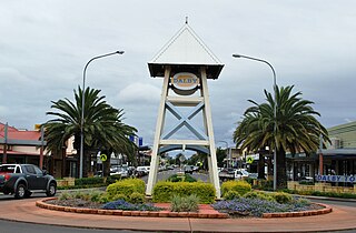
Dalby is a town and locality in the Darling Downs region of Queensland, Australia. Dalby is within and is the administrative centre of the Western Downs Region. At the 2016 census, Dalby had a population of 12,719.

Inglewood, Queensland Town in Queensland, Australia

Inglewood is a rural town and locality in the Goondiwindi Region, Queensland, Australia. In the 2016 census, Inglewood had a population of 954 people. Inglewood is the second largest town in the Goondiwindi Region.

Fortitude Valley, Queensland Suburb of Brisbane, Queensland, Australia

Fortitude Valley is an inner suburb of the City of Brisbane, the state capital of Queensland, Australia. In the 2016 census, Fortitude Valley had a population of 6,978 people.

Clifton, Queensland Town in Queensland, Australia

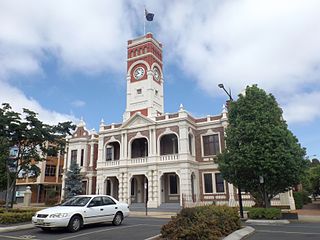
Clifton is a rural town and locality in the Toowoomba Region, Queensland, Australia. In the 2016 census, Clifton had a population of 1,456 people.

Laidley, Queensland Town in Queensland, Australia

Laidley is a rural town and locality in the Lockyer Valley Region, Queensland, Australia. In the 2016 census, Laidley had a population of 3,808 people.

Allora, Queensland Town in Queensland, Australia

Allora is a rural town and locality in the Southern Downs Region, Queensland, Australia. In the 2016 census, Allora had a population of 1,223 people.

Greenmount, Queensland (Toowoomba Region) Town in Queensland, Australia

Greenmount is a rural town and locality in the Toowoomba Region, Queensland, Australia. In the 2016 census the locality of Greenmount had a population of 699 people.

Roman Catholic Diocese of Toowoomba

The Roman Catholic Diocese of Toowoomba is a Latin Rite suffragan diocese of the Archdiocese of Brisbane, established in 1929, covering the Darling Downs and south west regions of Queensland, Australia.

Millmerran, Queensland Town in Queensland, Australia

Millmerran, known as Domville between 1 June 1889 and 16 November 1894, is a town and a locality in the Toowoomba Region, Queensland, Australia. In the 2016 census, Millmerran had a population of 1,563 people.

Ipswich (suburb), Queensland Suburb of Ipswich, Queensland, Australia

Ipswich is the central suburb of the City of Ipswich, Queensland, Australia. It is also known as Ipswich CBD. In the 2016 census, the suburb had a population of 2,459 people.

Goombungee, Queensland Town in Queensland, Australia

Goombungee is a rural town and locality in the Toowoomba Region, Queensland, Australia. In the 2016 census the locality of Goombungee had a population of 1,026 people.

Centenary Heights, Queensland Suburb of Toowoomba, Queensland, Australia

Centenary Heights is a residential locality in Toowoomba within the Toowoomba Region, Queensland, Australia. In the 2016 census, Centenary Heights had a population of 6,063 people.

Toowoomba City, Queensland Suburb of Toowoomba, Queensland, Australia

Toowoomba City is an urban locality in the Toowoomba Region, Queensland, Australia. It is the central suburb of Toowoomba, containing its central business district. In the 2016 census, Toowoomba City had a population of 2,088 people.

East Toowoomba, Queensland Suburb of Toowoomba, Queensland, Australia

East Toowoomba is a locality in the Toowoomba Region, Queensland, Australia. At the 2016 Australian Census East Toowoomba recorded a population of 5,244.

Harlaxton, Queensland Suburb of Toowoomba, Queensland, Australia

Harlaxton is a locality in the Toowoomba Region, Queensland, Australia. In the 2016 census, Harlaxton had a population of 2,547 people. Traditionally a rural area, most of the locality is now residential.

Harristown, Queensland Suburb of Toowoomba, Queensland, Australia

Harristown is a residential locality in Toowoomba in the Toowoomba Region, Queensland, Australia. In the 2016 census, Harristown had a population of 8,555 people.

Newtown, Queensland (Toowoomba) Suburb of Toowoomba, Queensland, Australia

Newtown is a residential locality in Toowoomba in the Toowoomba Region, Queensland, Australia. In the 2016 census, Newtown had a population of 9,596 people.

North Toowoomba, Queensland Suburb of Toowoomba, Queensland, Australia

North Toowoomba is an urban locality in Toowoomba in the Toowoomba Region, Queensland, Australia. In the 2016 census, North Toowoomba had a population of 2,953 people.

Rangeville, Queensland Suburb of Toowoomba, Queensland, Australia

Rangeville is a residential locality in Toowoomba in the Toowoomba Region, Queensland, Australia. In the 2016 census, Rangeville had a population of 8,312 people.

Haden, Queensland Town in Queensland, Australia

Haden is a rural town and locality in the Toowoomba Region, Queensland, Australia. In the 2016 census, Haden had a population of 195 people.

References

  1. 1 2 3 Australian Bureau of Statistics (27 June 2017). "South Toowoomba (SSC)". 2016 Census QuickStats. Retrieved 20 October 2018. OOjs UI icon edit-ltr-progressive.svg
  2. "South Toowoomba - locality in Toowoomba Region (entry 48061)". Queensland Place Names. Queensland Government . Retrieved 1 December 2019.
  3. "South Toowoomba (entry 48061)". Queensland Place Names. Queensland Government . Retrieved 28 August 2015.
  4. CC-BY-icon-80x15.png This Wikipedia article incorporates CC-BY-4.0 licensed text from: "Giabal". Queensland Aboriginal and Torres Strait Islander languages map. State Library of Queensland . Retrieved 23 January 2020.
  5. 1 2 Queensland Family History Society (2010), Queensland schools past and present (Version 1.01 ed.), Queensland Family History Society, ISBN   978-1-921171-26-0
  6. "Our History". St Saviours College Toowoomba. Archived from the original on 18 January 2020. Retrieved 18 January 2020.
  7. "Our history". St Saviour's Primary School, Toowoomba. Archived from the original on 4 March 2016. Retrieved 18 January 2020.
  8. "Opening and closing dates of Queensland Schools". Queensland Government . Retrieved 18 January 2020.
  9. City Golf Club. "City Golf Club - Golf". Archived from the original on 20 September 2015. Retrieved 10 August 2015.
  10. "Lake Annand - South Toowoomba". tr.qld.gov.au. Archived from the original on 25 October 2019. Retrieved 25 October 2019.
  11. 1 2 "State and non-state school details". Queensland Government. 9 July 2018. Archived from the original on 21 November 2018. Retrieved 21 November 2018.
  12. "St Saviour's Primary School". Archived from the original on 25 December 2018. Retrieved 21 November 2018.
  13. 1 2 "ACARA School Profile 2017". Archived from the original on 22 November 2018. Retrieved 22 November 2018.
  14. "St Saviour's College". Archived from the original on 18 February 2017. Retrieved 21 November 2018.
  15. "St Patricks Cathedral (entry 600844)". Queensland Heritage Register . Queensland Heritage Council. Retrieved 15 July 2013.
  16. "Toowoomba South State School (entry 602824)". Queensland Heritage Register . Queensland Heritage Council. Retrieved 1 August 2014.
  17. "Toowoomba Hospital (entry 601296)". Queensland Heritage Register . Queensland Heritage Council. Retrieved 15 July 2013.
  18. "Cottage (68 Stephen Street) (entry 601313)". Queensland Heritage Register . Queensland Heritage Council. Retrieved 15 July 2013.