Greenwood, Queensland

Last updated

Greenwood
Queensland
Australia Queensland location map.svg
Red pog.svg
Greenwood
Coordinates 27°20′12″S151°44′23″E / 27.3366°S 151.7397°E / -27.3366; 151.7397 (Greenwood (centre of locality))
Population34 (2021 census) [1]
 • Density1.95/km2 (5.06/sq mi)
Postcode(s) 4401
Area17.4 km2 (6.7 sq mi)
Time zone AEST (UTC+10:00)
LGA(s) Toowoomba Region
State electorate(s) Condamine
Federal division(s) Groom
Suburbs around Greenwood:
Acland Silverleigh Silverleigh
Acland Greenwood Silverleigh
Sabine Kelvinhaugh Kelvinhaugh

Greenwood is a rural locality in the Toowoomba Region, Queensland, Australia. [2] In the 2021 census, Greenwood had a population of 34 people. [1]

Contents

Geography

The land is freehold and use for agriculture, predominantly cropping. [3]

The Oakey–Cooyar Road runs through the north-western corner. [4]

History

The first Evangelical Lutheran Church in Queensland opened at Greenwood circa 1900. However, the Greenwood congregation outgrew the building so it was relocated to Yamsion to become its Evangelican Lutheran Church, where it was officially opened and dedicated on Thursday 18 May 1922. [5]

Greenwood Provisional School opened in 1907. On 1 January 1909, it became Greenwood State School. It closed in 1968. [6] It was at 1091 Oakey Cooyar Road ( 27°20′16″S151°43′45″E / 27.3379°S 151.7293°E / -27.3379; 151.7293 (Greenwood State School (site)) ). [7] [8]

Greenwood Methodist Church opened on 5 April 1959 at the top of the hill on Oakey-Cooyar Road, becoming the Greenwood Uniting Church after the 1977 amalgamation which formed the Uniting Church in Australia. In 1979, the Greenwood church building was relocated to Goombungee to become the Goombungee Uniting Church, while the former Goombungee Uniting Church became the church hall. On 26 August 2012, the former Greenwood church in Goombungee was decommissioned as a church and sold into private ownership. [9] [10]

Demographics

In the 2016 census, Greenwood had a population of 40 people. [11]

In the 2021 census, Greenwood had a population of 34 people. [1]

Related Research Articles

<span class="mw-page-title-main">Oakey, Queensland</span> Town in Queensland, Australia

Oakey is a rural town and locality in the Toowoomba Region, Queensland, Australia. The Museum of Army Aviation is located at Oakey Airport.

Peranga is a rural town and locality in the Toowoomba Region, Queensland, Australia. In the 2016 census the locality of Peranga had a population of 85 people.

<span class="mw-page-title-main">Goombungee, Queensland</span> Town in Queensland, Australia

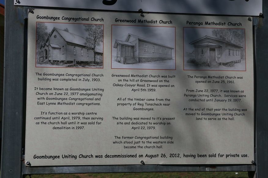
Goombungee is a rural town and locality in the Toowoomba Region, Queensland, Australia. In the 2016 census the locality of Goombungee had a population of 1,026 people.

Haden is a rural town and locality in the Toowoomba Region, Queensland, Australia. In the 2016 census, the locality of Haden had a population of 195 people.

<span class="mw-page-title-main">Aubigny, Queensland</span> Town in Queensland, Australia

Aubigny is a rural town and locality in the Toowoomba Region, Queensland, Australia. In the 2016 census, the locality of Aubigny had a population of 254 people.

<span class="mw-page-title-main">Maclagan, Queensland</span> Town in Queensland, Australia

Maclagan is a rural town and locality in the Toowoomba Region, Queensland, Australia. In the 2016 census the locality of Maclagan had a population of 195 people.

Kulpi is a rural town and locality in the Toowoomba Region, Queensland, Australia. In the 2016 census, the locality of Kulpi had a population of 77 people.

<span class="mw-page-title-main">Glencoe, Queensland</span> Suburb of Toowoomba Region, Queensland, Australia

Glencoe is a rural locality in the Toowoomba Region, Queensland, Australia. In the 2021 census, Glencoe had a population of 304 people.

<span class="mw-page-title-main">Boodua, Queensland</span> Suburb of Toowoomba Region, Queensland, Australia

Boodua is a rural locality in the Toowoomba Region, Queensland, Australia. In the 2021 census, Boodua had a population of 95 people.

<span class="mw-page-title-main">Gowrie Little Plain, Queensland</span> Suburb of Toowoomba Region, Queensland, Australia

Gowrie Little Plain is a rural locality in the Toowoomba Region, Queensland, Australia. In the 2021 census, Gowrie Little Plain had a population of 79 people.

<span class="mw-page-title-main">Bergen, Queensland</span> Suburb of Toowoomba Region, Queensland, Australia

Bergen is a rural locality in the Toowoomba Region, Queensland, Australia. In the 2021 census, Bergen had a population of 85 people.

Evergreen is a rural town and locality in the Toowoomba Region, Queensland, Australia. In the 2016 census, the locality of Evergreen had a population of 45 people.

Kelvinhaugh is a rural locality in the Toowoomba Region, Queensland, Australia. In the 2021 census, Kelvinhaugh had a population of 49 people.

Nutgrove is a rural locality in the Toowoomba Region, Queensland, Australia. In the 2016 census Nutgrove had a population of 32 people.

<span class="mw-page-title-main">Silverleigh, Queensland</span> Suburb of Toowoomba Region, Queensland, Australia

Silverleigh is a rural locality in the Toowoomba Region, Queensland, Australia. In the 2016 census, Silverleigh had a population of 71 people.

<span class="mw-page-title-main">Douglas, Queensland (Toowoomba Region)</span> Suburb of Toowoomba Region, Queensland, Australia

Douglas is a rural locality in the Toowoomba Region, Queensland, Australia. In the 2021 census, Douglas had a population of 152 people.

<span class="mw-page-title-main">Highland Plains, Queensland (Toowoomba Region)</span> Suburb of Toowoomba Region, Queensland, Australia

Highland Plains is a rural locality in the Toowoomba Region, Queensland, Australia. In the 2021 census, Highland Plains had a population of 60 people.

Mount Darry is a rural locality in the Toowoomba Region, Queensland, Australia. In the 2016 census Mount Darry had a population of 35 people.

Narko is a rural locality in the Toowoomba Region, Queensland, Australia. In the 2021 census, Narko had a population of 16 people.

Oakey–Cooyar Road is a continuous 58.8 kilometres (36.5 mi) road route in the Darling Downs and Toowoomba regions of Queensland, Australia. The entire route is signed as State Route 68. It is a state-controlled part regional and part district road. It provides an alternate route between the Warrego Highway and the New England Highway, bypassing Toowoomba.

References

  1. 1 2 3 Australian Bureau of Statistics (28 June 2022). "Greenwood (SAL)". 2021 Census QuickStats. Retrieved 28 February 2023. OOjs UI icon edit-ltr-progressive.svg
  2. "Greenwood – locality in Toowoomba Region (entry 47960)". Queensland Place Names. Queensland Government . Retrieved 29 December 2020.
  3. "Queensland Globe". State of Queensland . Retrieved 30 December 2017.
  4. Greenwood, Queensland (Map). OpenStreetMap. Retrieved 18 January 2022.
  5. "DALBY". The Brisbane Courier . No. 20, 070. Queensland, Australia. 19 May 1922. p. 8. Retrieved 27 February 2021 via National Library of Australia.
  6. Queensland Family History Society (2010), Queensland schools past and present (Version 1.01 ed.), Queensland Family History Society, ISBN   978-1-921171-26-0
  7. "Parish of King County of Aubigny" (Map). Queensland Government. 1942. Archived from the original on 17 December 2020. Retrieved 17 December 2020.
  8. "Queensland Globe". State of Queensland . Retrieved 16 December 2020.
  9. "Noticeboard outside Goombungee Uniting Church, 6 George Street". Churches Australia. Archived from the original on 17 December 2020. Retrieved 17 December 2020.
  10. "Goombungee Uniting Church - Former". Churches Australia. Archived from the original on 17 December 2020. Retrieved 17 December 2020.
  11. Australian Bureau of Statistics (27 June 2017). "Greenwood (SSC)". 2016 Census QuickStats. Retrieved 20 October 2018. OOjs UI icon edit-ltr-progressive.svg

Further reading