Lavelle, Queensland

Last updated

Lavelle
Queensland
Australia Queensland location map.svg
Red pog.svg
Lavelle
Coordinates 28°00′00″S151°17′00″E / 28.0000°S 151.2833°E / -28.0000; 151.2833 (Lavelle (centre of locality)) Coordinates: 28°00′00″S151°17′00″E / 28.0000°S 151.2833°E / -28.0000; 151.2833 (Lavelle (centre of locality))
Population29 (2016 census) [1]
 • Density1.429/km2 (3.70/sq mi)
Postcode(s) 4357
Area20.3 km2 (7.8 sq mi)
Time zone AEST (UTC+10:00)
LGA(s) Toowoomba Region
State electorate(s) Southern Downs
Federal Division(s) Maranoa
Suburbs around Lavelle:
Clontarf Grays Gate Grays Gate
Clontarf Lavelle Rocky Creek
Kooroongarra Mount Emlyn Mount Emlyn

Lavelle is a rural locality in the Toowoomba Region, Queensland, Australia. [2] In the 2016 census Lavelle had a population of 29 people. [1]

History

The locality was named after Martin Lavelle, a surveyor, who surveyed the Lavelle and surrounding areas in the 1880s. [2]

Lavelle Provisional School opened on 4 May 1926. On 29 January 1936 it became Lavelle State School. It closed on 31 December 1957. [3] It was on Kooroongarra Road at approx 27°59′17″S151°17′00″E / 27.9880°S 151.2834°E / -27.9880; 151.2834 (Lavelle State School (former)) . [4] [5]

In the 2016 census Lavelle had a population of 29 people. [1]

Related Research Articles

Gowrie Junction, Queensland Suburb of Toowoomba Region, Queensland, Australia

Gowrie Junction is a rural locality in the Toowoomba Region, Queensland, Australia. It is north-west of Toowoomba. In the 2016 census, Gowrie Junction had a population of 2,120 people. The town of Gowrie is in the eastern part of the locality.

Greenmount, Queensland (Toowoomba Region) Town in Queensland, Australia

Greenmount is a rural town and locality in the Toowoomba Region, Queensland, Australia. In the 2016 census the locality of Greenmount had a population of 699 people.

Cecil Plains, Queensland Town in Queensland, Australia

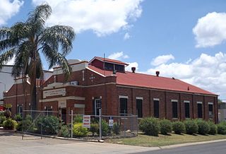
Cecil Plains is a rural town and locality in the Toowoomba Region, Queensland, Australia. In the 2016 census, Cecil Plains had a population of 429 people.

Vale View, Queensland Suburb of Toowoomba, Queensland, Australia

Vale View is a rural locality in the Toowoomba Region, Queensland, Australia. In the 2016 census, Vale View had a population of 472 people.

North Toowoomba, Queensland Suburb of Toowoomba, Queensland, Australia

North Toowoomba is an urban locality in Toowoomba in the Toowoomba Region, Queensland, Australia. In the 2016 census, North Toowoomba had a population of 2,953 people.

Aubigny, Queensland Town in Queensland, Australia

Aubigny is a rural town and locality in the Toowoomba Region, Queensland, Australia. In the 2016 census, Aubigny had a population of 254 people.

East Greenmount, Queensland Suburb of Toowoomba Region, Queensland, Australia

East Greenmount is a rural town and locality in the Toowoomba Region, Queensland, Australia. In the 2016 census the locality of East Greenmount had a population of 361 people.

Ascot, Queensland (Toowoomba Region) Suburb of Toowoomba Region, Queensland, Australia

Ascot is a rural locality in the Toowoomba Region, Queensland, Australia. In the 2016 census, Ascot had a population of 31 people.

Spring Creek, Queensland (Darling Downs) Suburb of Toowoomba Region, Queensland, Australia

Spring Creek is a locality split between the Toowoomba Region and the Southern Downs Region, Queensland, Australia.

Brookstead, Queensland Town in Queensland, Australia

Brookstead is a rural town and locality in the Toowoomba Region, Queensland, Australia. In the 2016 census, Brookstead had a population of 217 people.

Branchview, Queensland Suburb of Toowoomba Region, Queensland, Australia

Branchview is a rural locality in the Toowoomba Region, Queensland, Australia. In the 2016 census Branchview had a population of 17 people.

Kelvinhaugh, Queensland Suburb of Toowoomba Region, Queensland, Australia

Kelvinhaugh is a rural locality in the Toowoomba Region, Queensland, Australia. In the 2016 census Kelvinhaugh had a population of 44 people.

Kilbirnie, Queensland Suburb of Toowoomba Region, Queensland, Australia

Kilbirnie is a rural locality in the Toowoomba Region, Queensland, Australia. In the 2016 census Kilbirnie had a population of 60 people.

Mount Emlyn, Queensland Suburb of Toowoomba Region, Queensland, Australia

Mount Emlyn is a rural locality in the Toowoomba Region, Queensland, Australia. In the 2016 census Mount Emlyn had a population of 16 people.

Nangwee, Queensland Town in Queensland, Australia

Nangwee is a rural town and locality in the Toowoomba Region, Queensland, Australia. In the 2016 census the locality of Nangwee had a population of 52 people.

Norwin, Queensland Suburb of Toowoomba Region, Queensland, Australia

Norwin is a rural locality in the Toowoomba Region, Queensland, Australia. In the 2016 census Norwin had a population of 94 people.

Nutgrove, Queensland Suburb of Toowoomba Region, Queensland, Australia

Nutgrove is a rural locality in the Toowoomba Region, Queensland, Australia. In the 2016 census Nutgrove had a population of 32 people.

Silverleigh, Queensland Suburb of Toowoomba Region, Queensland, Australia

Silverleigh is a rural locality in the Toowoomba Region, Queensland, Australia. In the 2016 census Silverleigh had a population of 71 people.

Yargullen Suburb of Toowoomba Region, Queensland, Australia

Yargullen is a rural locality in the Toowoomba Region, Queensland, Australia. In the 2016 census Yargullen had a population of 25 people.

Gilla, Queensland Suburb of Toowoomba Region, Queensland, Australia

Gilla is a rural locality in the Toowoomba Region, Queensland, Australia. In the 2016 census Gilla had a population of 32 people.

References

  1. 1 2 3 Australian Bureau of Statistics (27 June 2017). "Lavelle (SSC)". 2016 Census QuickStats. Retrieved 20 October 2018. OOjs UI icon edit-ltr-progressive.svg
  2. 1 2 "Lavelle – locality in Toowoomba Region (entry 47988)". Queensland Place Names. Queensland Government . Retrieved 29 December 2020.
  3. Queensland Family History Society (2010), Queensland schools past and present (Version 1.01 ed.), Queensland Family History Society, ISBN   978-1-921171-26-0
  4. "Parish of Gore County of Merivale" (Map). Queensland Government. 1940. Archived from the original on 10 January 2021. Retrieved 10 January 2021.
  5. "Queensland Globe". State of Queensland . Retrieved 10 January 2021.