Boodua, Queensland

Last updated

Map all coordinates using: OpenStreetMap
Boodua
Queensland
Fields at Boodua.jpg
Fields along Kingsthorpe Haden Road
Australia Queensland location map.svg
Red pog.svg
Boodua
Coordinates 27°22′40″S151°49′36″E / 27.3777°S 151.8266°E / -27.3777; 151.8266 (Boodua (centre of locality))
Population93 (2016 census) [1]
 • Density3.811/km2 (9.87/sq mi)
Postcode(s) 4401
Area24.4 km2 (9.4 sq mi)
Time zone AEST (UTC+10:00)
LGA(s) Toowoomba Region
State electorate(s) Condamine
Federal division(s) Groom
Suburbs around Boodua:
Silverleigh Goombungee Muniganeen
Silverleigh
Kelvinhaugh
Boodua Muniganeen
Kelvinhaugh Yalangur Yalangur

Boodua is a rural locality in the Toowoomba Region, Queensland, Australia. [2] In the 2016 census Boodua had a population of 93 people. [1]

Contents

Geography

Part of the eastern and southern boundary of Boodua follows Oakey Creek, a tributary of the Condamine River. The predominant land use is agriculture.

History

Boodua State School (formerly East Lynne State School) Boodua State School (formerly East Lynne State School).jpg
Boodua State School (formerly East Lynne State School)

The name originates from the Boodua railway station on the Haden railway line and is an Aboriginal word for a species of hawk. [3] [4]

East Lynne Provisional School opened on 1 October 1908. On 1 January 1909 it became East Lynne State School. In 1926, it was renamed Boodua State School. It closed on 29 January 1963. [5] It was at 5 Boodua West Road ( 27°22′28″S151°49′51″E / 27.3745°S 151.8307°E / -27.3745; 151.8307 (Boodua State School (former)) ). [6] [7]

The Boodua Public Hall opened in 1909. [8] It was originally known as the East Lynne Hall. [9]

On Sunday 14 September 1913 the East Lynne Methodist Church was officially opened by Reverend W. Goddard of Toowoomba. It was 20 by 30 feet (6.1 by 9.1 m) and was built near the railway line near Boodua railway station, next door to the state school and the public hall (approx 27°22′27″S151°49′51″E / 27.3741°S 151.8307°E / -27.3741; 151.8307 (East Lynne Methodist Church) ). [10] In 1977, as part of the creation of the Uniting Church in Australia, the East Lynne Methodist congregation merged with the Goombungee Congregational Church to form the Goombungee Uniting Church (which closed on 26 August 2012). [11] [12] The East Lynne Methodist Church no longer exists.

The Darling Downs Co-operative Dairy Association operated a cheese factory at Boodua between 1926 and 1950.[ citation needed ]

The area was once part of the Shire of Rosalie until it was merged into the Toowoomba Region in 2008.

In the 2016 census Boodua had a population of 93 people. [1]

Amenities

Boodua Public Hall, 2014 Boodua public hall.jpg
Boodua Public Hall, 2014

The Boodua Public Hall is at 1473 Kingsthorpe Haden Road (corner of Boodua West Road, 27°22′26″S151°49′51″E / 27.3739°S 151.8308°E / -27.3739; 151.8308 (Boodua Public Hall) ). [8]

Related Research Articles

<span class="mw-page-title-main">Oakey, Queensland</span> Town in Queensland, Australia

Oakey is a rural town and locality in the Toowoomba Region, Queensland, Australia. The Museum of Army Aviation is located at Oakey Airport.

Glenvale is a rural locality in the Toowoomba Region, Queensland, Australia. It is a suburb of Toowoomba. In the 2016 census, Glenvale had a population of 6,353 people.

<span class="mw-page-title-main">Shire of Rosalie</span> Local government area in Queensland, Australia

The Shire of Rosalie was a local government area in the Darling Downs region of Queensland, Australia, immediately northwest of the regional city of Toowoomba. The shire, administered from the town of Goombungee, covered an area of 2,200.7 square kilometres (849.7 sq mi), and existed as a local government entity from 1879 until 2008. In 2008, it amalgamated with several other councils in the Toowoomba area to form the Toowoomba Region.

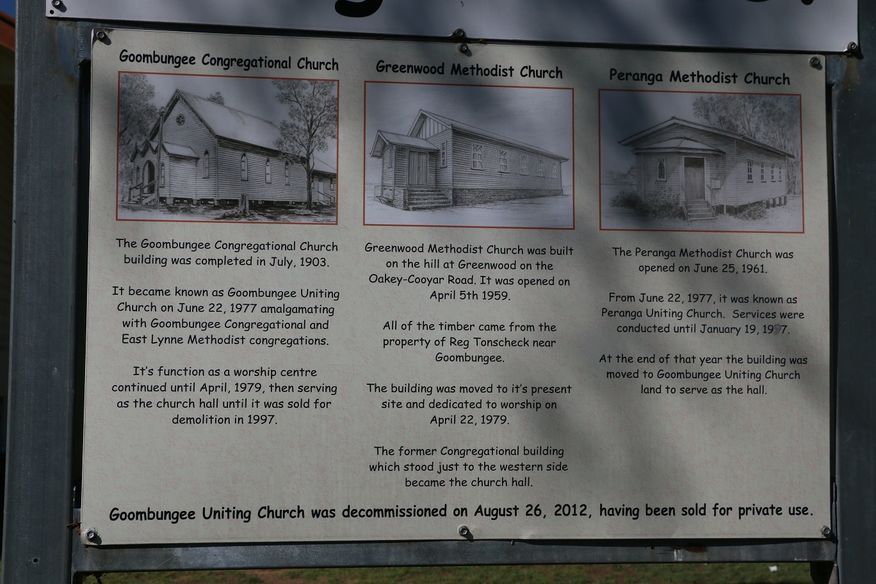
Peranga is a rural town and locality in the Toowoomba Region, Queensland, Australia. In the 2016 census the locality of Peranga had a population of 85 people.

<span class="mw-page-title-main">Kingsthorpe, Queensland</span> Town in Queensland, Australia

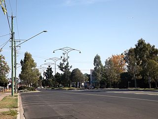
Kingsthorpe is a rural town and locality in the Toowoomba Region, Queensland, Australia. In the 2021 census, the locality of Kingsthorpe had a population of 2,159 people.

<span class="mw-page-title-main">Acland, Queensland</span> Town in Queensland, Australia

Acland is a rural town and locality in the Toowoomba Region, Queensland, Australia. In the 2016 census the locality of Acland had a population of 32 people.

<span class="mw-page-title-main">Goombungee, Queensland</span> Town in Queensland, Australia

Goombungee is a rural town and locality in the Toowoomba Region, Queensland, Australia. In the 2016 census the locality of Goombungee had a population of 1,026 people.

Haden is a rural town and locality in the Toowoomba Region, Queensland, Australia. In the 2016 census, the locality of Haden had a population of 195 people.

<span class="mw-page-title-main">Aubigny, Queensland</span> Town in Queensland, Australia

Aubigny is a rural town and locality in the Toowoomba Region, Queensland, Australia. In the 2016 census, the locality of Aubigny had a population of 254 people.

<span class="mw-page-title-main">Maclagan, Queensland</span> Town in Queensland, Australia

Maclagan is a rural town and locality in the Toowoomba Region, Queensland, Australia. In the 2016 census the locality of Maclagan had a population of 195 people.

<span class="mw-page-title-main">Gowrie Little Plain, Queensland</span> Suburb of Toowoomba Region, Queensland, Australia

Gowrie Little Plain is a rural locality in the Toowoomba Region, Queensland, Australia. In the 2016 census, Gowrie Little Plain had a population of 65 people.

Evergreen is a rural town and locality in the Toowoomba Region, Queensland, Australia. In the 2016 census, the locality of Evergreen had a population of 45 people.

Devon Park is a rural locality in the Toowoomba Region, Queensland, Australia. In the 2016 census, Devon Park had a population of 49 people.

Greenwood is a rural locality in the Toowoomba Region, Queensland, Australia. In the 2016 census, Greenwood had a population of 40 people.

Kelvinhaugh is a rural locality in the Toowoomba Region, Queensland, Australia. In the 2016 census, Kelvinhaugh had a population of 44 people.

Norwin is a rural locality in the Toowoomba Region, Queensland, Australia. In the 2016 census, Norwin had a population of 94 people.

Silverleigh is a rural locality in the Toowoomba Region, Queensland, Australia. In the 2016 census, Silverleigh had a population of 71 people.

Cutella is a rural locality in the Toowoomba Region, Queensland, Australia. In the 2021 census, Cutella had a population of 45 people.

Mount Darry is a rural locality in the Toowoomba Region, Queensland, Australia. In the 2016 census Mount Darry had a population of 35 people.

Oakey–Cooyar Road is a continuous 58.8 kilometres (36.5 mi) road route in the Darling Downs and Toowoomba regions of Queensland, Australia. The entire route is signed as State Route 68. It is a state-controlled part regional and part district road. It provides an alternate route between the Warrego Highway and the New England Highway, bypassing Toowoomba.

References

  1. 1 2 3 Australian Bureau of Statistics (27 June 2017). "Boodua (SSC)". 2016 Census QuickStats. Retrieved 20 October 2018. OOjs UI icon edit-ltr-progressive.svg
  2. "Boodua – locality in Toowoomba Region (entry 47894)". Queensland Place Names. Queensland Government . Retrieved 29 December 2020.
  3. "Nomenclature of Queensland – 49". The Courier-Mail . Brisbane: National Library of Australia. 25 November 1935. p. 10. Archived from the original on 17 December 2020. Retrieved 13 November 2014.
  4. "Jondaryan" (Map). Queensland Government. 1943. Retrieved 2 September 2023.
  5. Queensland Family History Society (2010), Queensland schools past and present (Version 1.01 ed.), Queensland Family History Society, ISBN   978-1-921171-26-0
  6. "Parish of King County of Aubigny" (Map). Queensland Government. 1942. Archived from the original on 17 December 2020. Retrieved 17 December 2020.
  7. "Queensland Globe". State of Queensland . Retrieved 16 December 2020.
  8. 1 2 "Boodua Public Hall Association Incorporated". Australian Charities and Not-for-profits Commission . 1 October 2020. Archived from the original on 17 December 2020. Retrieved 17 December 2020.
  9. "Farmers' Union". Darling Downs Gazette . Vol. LIV, no. 9861. Queensland, Australia. 26 September 1911. p. 4. Retrieved 17 December 2020 via National Library of Australia.
  10. "District News". Darling Downs Gazette . Vol. LVI, no. 535. Queensland, Australia. 22 September 1913. p. 7. Archived from the original on 17 December 2020. Retrieved 17 December 2020 via National Library of Australia.
  11. "Noticeboard outside Goombungee Uniting Church, 6 George Street". Churches Australia. Archived from the original on 17 December 2020. Retrieved 17 December 2020.
  12. "Goombungee Uniting Church - Former". Churches Australia. Archived from the original on 17 December 2020. Retrieved 17 December 2020.

Further reading

Commons-logo.svg Media related to Boodua, Queensland at Wikimedia Commons