
Ewenny Priory, in Ewenny in the Vale of Glamorgan, Wales, was a monastery of the Benedictine order, founded in the 12th century. The priory was unusual in having extensive military-style defences and in its state of preservation; the architectural historian John Newman described it as “the most complete and impressive Norman ecclesiastical building in Glamorgan”. Following the Dissolution of the Monasteries, parts of the priory were converted into a private house by Sir Edward Carne, a lawyer and diplomat. This Elizabethan house was demolished between 1803 and 1805 and replaced by a Georgian mansion, Ewenny Priory House. The house is still owned by the Turbervill family, descendants of Sir Edward. The priory is not open to the public apart from the Church of St Michael, the western part of the priory building, which continues to serve as the parish church for the village. The priory is in the care of Cadw and is a Grade I listed building.

Merthyr Mawr is a village and community in Bridgend, Wales. The village is about 2+1⁄2 miles from the centre of Bridgend town. The population of the community at the 2011 census was 267. The community occupies the area west of the Ewenny River, between Bridgend and Porthcawl. It takes in the settlement of Tythegston and a stretch of coastal sand dunes known as Merthyr Mawr Warren. It is in the historic county of Glamorgan.

Penally is a coastal village, parish and community 1 mile (1.6 km) southwest of Tenby in Pembrokeshire, Wales. The village is known for its Celtic Cross, Penally Abbey, the neighbouring St. Deiniol's Well, WWI Practice trenches, and Penally Training Camp.

Lamphey is both a village, a parish and a community near the south coast of Pembrokeshire, Wales, approximately 2 miles (3.2 km) east of the town of Pembroke, and 2 miles (3.2 km) north of the seaside village of Freshwater East. The 2011 census reported a population of 843.

Raglan (; is a village and community in Monmouthshire, south-east Wales, United Kingdom. It is located some 9 miles south-west of Monmouth, midway between Monmouth and Abergavenny on the A40 road very near to the junction with the A449 road. It is the location of Raglan Castle, built for William ap Thomas and now maintained by Cadw. The community includes the villages of Llandenny and Pen-y-clawdd. Raglan itself has a population of 1,183.
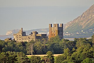
Penrhyn Castle is a country house in Llandygai, Bangor, Gwynedd, North Wales, constructed in the style of a Norman castle. The Penrhyn estate was founded by Ednyfed Fychan. In the 15th century his descendant Gwilym ap Griffith built a fortified manor house on the site. In the 18th century, the Penrhyn estate came into the possession of Richard Pennant, 1st Baron Penrhyn, in part from his father, a Liverpool merchant, and in part from his wife, Ann Susannah Pennant née Warburton, the daughter of an army officer. Pennant derived great wealth from his ownership of slave plantations in the West Indies and was a strong opponent of attempts to abolish the slave trade. His wealth was used in part for the development of the slate mining industry on Pennant's Caernarfonshire estates, and also for development of Penrhyn Castle. In the 1780s Pennant commissioned Samuel Wyatt to undertake a reconstruction of the medieval house.

Llanerchaeron, known as "Llanayron House" to its nineteenth-century occupants, is a grade I listed mansion on the River Aeron, designed and built in 1795 by John Nash for Major William Lewis as a model self-sufficient farm complex located near Ciliau Aeron, some 2+1⁄2 miles south-east of Aberaeron, Ceredigion, Wales. There is evidence that the house replaced an earlier mansion. A later owner, William Lewes, was the husband of Colonel Lewis's inheriting daughter.

St John's is a grade II listed building in the town centre of Monmouth, Wales. It is located in Glendower Street within the medieval town walls. The house is most remarkable for the rear of the property which features a Coalbrookdale verandah and formal walled garden that have been separately grade II listed with the Cadw/ICOMOS Register of Parks and Gardens of Special Historic Interest in Wales. The villa's garden is also registered with the Welsh Historic Gardens Trust.

This is a list of Grade I-listed buildings in the county of Pembrokeshire, Wales.
This is a list of Grade II*-listed buildings in the county of Pembrokeshire, Wales.

Moynes Court is a Grade II* listed building in the village of Mathern, Monmouthshire, Wales, about 3 miles (4.8 km) south west of Chepstow. An earlier building was rebuilt as a private residence by Francis Godwin, Bishop of Llandaff, in about 1609/10, and much of the building remains from that period. Its grounds contain earthworks thought to be the foundations of an earlier moated manor house. The gatehouse to the court has a separate Grade II* listing. The garden at the court is on the Cadw/ICOMOS Register of Parks and Gardens of Special Historic Interest in Wales.
Pembrokeshire is a county in the south-west of Wales. It covers an area of 1,619 km2 (625 sq mi). In 2021 the population was approximately 123,700.
Whitewell Ruins is a historic site on the edge of the village of Penally, Pembrokeshire, Wales. The site consists of three structures, called A, B and C. The purposes of the structures are not fully understood, although sources agree that the largest, Whitewell Ruins: Structure A, was a medieval manor house and that Structures B and C served as ancillary buildings of some type. All three structures are Grade I listed buildings and the site is a Scheduled monument.
West Tarr Mediaeval House is a historic site south of the village of St Florence, in the community of Penally, Pembrokeshire, Wales. The site consists of two structures, the remains of the house and an ancillary building. The house is a Grade I listed building and a Scheduled monument. The outbuilding is listed at Grade II.

The Tower at Eastington Manor is a historic site south of the village of Rhoscrowther, in the community of Angle, Pembrokeshire, Wales. The tower is to a tower house plan and dates from the 14th or 15th centuries. A range of later buildings is attached. The tower is a Grade I listed building and a Scheduled monument. The range is listed at Grade II.


