Hogsback, South Africa

Last updated

Hogsback
Nickname: 
"Where the fairies live"
South Africa Eastern Cape location map.svg
Red pog.svg
Hogsback
South Africa adm location map.svg
Red pog.svg
Hogsback
Africa location map.svg
Red pog.svg
Hogsback
Coordinates: 32°35′53″S26°56′17″E / 32.598°S 26.938°E / -32.598; 26.938 Coordinates: 32°35′53″S26°56′17″E / 32.598°S 26.938°E / -32.598; 26.938
Country South Africa
Province Eastern Cape
District Amathole
Municipality Raymond Mhlaba
Area
[1]
  Total13.78 km2 (5.32 sq mi)
Population
 (2011) [1]
  Total1,029
  Density75/km2 (190/sq mi)
Racial makeup (2011)
[1]
   Black African 65.7%
   Coloured 2.2%
   Indian/Asian 0.5%
   White 30.5%
  Other1.1%
First languages (2011)
[1]
   Xhosa 63.5%
   English 27.7%
   Afrikaans 6.0%
  Other2.9%
Time zone UTC+2 (SAST)
PO box
5721
Area code 045
Website http://www.hogsback.com/
View from The Edge to the Tyhume valley with the Hogsback Pass street Blick ins tyhume-valley.jpg
View from The Edge to the Tyhume valley with the Hogsback Pass street
View to Tor Doone near the Hogsback Pass View of tor doone to ssw.jpg
View to Tor Doone near the Hogsback Pass
The Hog's from southwest Amathole mountains, indigenous forest.jpg
The Hog's from southwest

Hogsback is a village in the Amathole Mountains in the Eastern Cape Province, South Africa.

Contents

Name

There are two (or maybe more) theories as how the village received its name. Some think it was named for Captain Hogg, Commander of Fort Michell. Others think that it is because one of the three peaks that overlook the village, when seen from a certain angle, resembles a Hog's Back (A hog's back is a geological term describing this particular rock formation).

History

The earliest known written reference to 'Hogsback' was found in the journal of the painter Thomas Baines, who passed the 'Hogs Back' while on his travels deeper inside South Africa in 1848. Besides the 'Hogsback', the highest peak in the area is the 1 954 m Gaika's Kop.

The nearby Xhosa tribes called the surrounding area Qabimbola (meaning 'red clay on the face') as the surrounding clay was used for face painting. Gaika's Kop was one of the Xhosa strongholds. British troops were later stationed here and a number of forts were built to guard the border with the Xhosa. One of these forts was Fort Michell, named after Colonel Michell of the Warwickshire regiment, who was at one point in charge of troops in the area. The name has since changed to Fort Mitchell. The outline of Fort Michell, and the first road from Fort Hare can still be seen.

The conflict between the British and Xhosa continued further north and a small settlement began to grow. Some of the first inhabitants of Hogsback were Summerton, Odendaal and Booysens. Thomas Summerton, a gardener from Oxford, has a legacy that survives in the local gardens and his attempts to re-create the English countryside. This can be seen in apple orchards, avenues lined with hazelnut trees, berry fruits and the flowering plants that have spread throughout the surrounding area. European flowers, bushes and trees include rhododendrons, azaleas, fruits and berries. He named his farm Cherrie Orchard and also built a furrow – Summerton's furrow – to carry water from a stream on Tor Doone.

In the 1880s, Collins built a small hotel, called the Hogsback Hydro, of which later became the Hogsback Inn. Hunterstoun, the private estate of David Hunter, was built in 1910. Hunter was the honorary secretary and treasurer of the Lovedale Institution and the Victoria College near Alice. Forestry began in 1883 with a survey to determine the best areas for planting. The Hogsback pass was opened in 1932. Hobbiton-on-Hogsback was started in 1946 as a holiday camp for children who could not afford to go on holidays and with the aid of several organisations and private donations, had grown to an outdoor education facility for underprivileged children. There was also a shop, the Handy Log Cabin, situated in the grounds of Arminel.

At the turn of the century, local farmers and townsfolk started to build holiday homes here and its charms became more widely known. The cottages were mostly of wattle and daub with thatched roofs. A rule was also made in regard to the size of the plots, namely that each one had to be at least two morgen. [2]

Geography and tourism

The area is known for indigenous forests, waterfalls and trout fishing. The large gardens in the surrounding area also include exotic plants from all parts of the world, and it is a destination and tourist attraction among both international and South African tourists. [3] Apart from 'the Hogsback', the tallest peak in the area is the 1 954 m Gaika's Kop.

Hiking and walking trails

There are a number of hiking routes and walks that take walkers through the forests, up mountains, past waterfalls and to viewing points and views of the area. [4] General information on Hogsback such as maps of walks, hiking and mountain bike trails are available for purchase from the Hogsback Tourist Office located near the entrance of the village. These trails vary from short easy walks to trails taking 3–4 hours and longer. Hogsback hiking trails include: [5] The Labyrinth at the Edge, The 39 Steps Falls and Arboretum, Madonna and Child Falls, Kettlespout Falls, The Three Hogs, Tyumy Pools walk, The Three Waterfall Trail, The Bluff Walk, The Military Path, The Sunset Loop, The Big Tree and The Art and Craft Trail.

Tolkien

The Amatola Forest in the Hogsback area is often claimed as J. R. R. Tolkien's inspiration for The Lord of the Rings, in particular for his fictional forest of Mirkwood. The link between Tolkien and Hogsback would seem to be a back formation from the establishment in 1947 of Hobbiton on Hogsback, [6] a holiday and educational camp for underprivileged children. This was ten years after the publication of The Hobbit which was a huge success and which would have inspired the camp's founders as they set up in such an evocatively forested area.

Climate

Hogsback has a cool Oceanic Climate (Köppen Cfb), which compares similarly to the climate of England. It has a climate range from as low as 3.5 °C in July to as high as 34.9 °C in January. Hogsback receives an average annual precipitation of 974mm. Hogsback receives most of its rainfall in summer, often accompanied by thunderstorms.

Location

Hogsback is located roughly 30 km from Alice. Overall, it is in the central-southern part of South Africa, in the centre of the Eastern Cape province, and is roughly halfway between the town of Alice and the village of Cathcart. Nearby towns include Seymour to the west and Alice to the south, Cathcart, Whittlesea and the Waterdown Dam to the north and Keiskammahoek to the east. However, travel east and west of the town is rare because there is little infrastructure and ridges/mountains to these sides.

Transportation

The village is located on the R345, that runs from Fort Hare up to Cathcart. This is very much the only route of communication for the village because the small unpaved roads to the west and east are dangerous and not recommended for motor traversing.

Religion

St Patrick's on the Hill is a small chapel consisting of two combined rondavels, a neat thatched roof, above which rises a single cross. The church also boasts a 'bright' garden, which is full of rhododendrons and azaleas. There is a stone arch with a brass bell that stands as a memorial for the Revd Dr Bride Dixon, first woman priest in South Africa, and doctor on the mountain for many years. [7] The chapel was built in 1935 and is a regular place of worship, and although it is officially part of the Anglican Diocese of Grahamstown, the church is open to people of all Christian denominations such as Presbyterians, Methodists, Nederduits Gereformeerde Kerk (Dutch Reformed Church) and Anglicans. The chapel began when Kenneth Hobart Houghton, the owner of the property conceived of the idea to give to his wife a special place to worship. It was first designed as a single rondavel and in time as the local congregation grew, it became necessary to extend it. The second rondavel which gives it its characteristic butternut shape was added in 1992. Currently the chapel is open 24 hours a day.

Related Research Articles

<span class="mw-page-title-main">Multnomah Falls</span> Waterfall in Oregon, U.S.

Multnomah Falls is a waterfall located on Multnomah Creek in the Columbia River Gorge, east of Troutdale, between Corbett and Dodson, Oregon, United States. The waterfall is accessible from the Historic Columbia River Highway and Interstate 84. Spanning two tiers on basalt cliffs, it is the tallest waterfall in the state of Oregon at 620 ft (189 m) in height. The Multnomah Creek Bridge, built in 1914, crosses below the falls, and is listed on the National Register of Historic Places.

<span class="mw-page-title-main">Fort Mountain State Park</span> State park in Georgia, United States

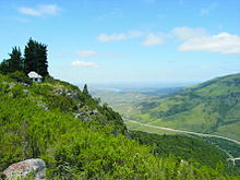
Fort Mountain State Park is a 3,712-acre (15.02 km2) Georgia state park located between Chatsworth and Ellijay on Fort Mountain. The state park was founded in 1938 and is named for an ancient 885-foot-long (270 m) rock wall located on the peak. The nomination form for the National Register of Historic Places describes the wall as "more of a marker than a fortification, separating the north peak from the southern end."

<span class="mw-page-title-main">Bhandardara</span> Village in Maharashtra, India

Bhandardara is a holiday resort village near Igatpuri, in the western ghats of India. The village is located in the Akole tehsil, Ahmednagar district of the state of Maharashtra, about 185 kilometers (115 mi) from Mumbai and 155 kilometers (96 mi) from Ahmednagar.

<span class="mw-page-title-main">Tsitsikamma National Park</span> Protected area on the Garden Route, Western Cape and Eastern Cape, South Africa

The Tsitsikamma National Park is a protected area on the Garden Route, Western Cape and Eastern Cape, South Africa. It is a coastal reserve well known for its indigenous forests, dramatic coastline, and the Otter Trail. On 6 March 2009 it was amalgamated with the Wilderness National Park and various other areas of land to form the Garden Route National Park.

<span class="mw-page-title-main">Amathole Mountains</span> Mountain range in South Africa

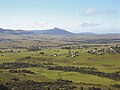
Amatola, Amatole or Amathole are a range of densely forested mountains, situated in the Eastern Cape province of South Africa. The word Amathole means ‘calves’ in Xhosa, and Amathole District Municipality, which lies to the south, is named after these mountains.

<span class="mw-page-title-main">Ohiopyle State Park</span>

Ohiopyle State Park is a Pennsylvania state park on 20,500 acres (8,300 ha) in Dunbar, Henry Clay and Stewart Townships, Fayette County, Pennsylvania in the United States. The focal point of the park is the more than 14 miles (23 km) of the Youghiogheny River Gorge that passes through the park. The river provides some of the best whitewater boating in the Eastern United States. Ohiopyle State Park is bisected by Pennsylvania Route 381 south of the Pennsylvania Turnpike. The park opened to the public in 1965 but was not officially dedicated until 1971.

<span class="mw-page-title-main">Laurel Falls Trail</span>

The Laurel Falls Trail is an American hiking trail, in the Great Smoky Mountains National Park of Sevier County, Tennessee. The trail ascends Cove Mountain, leading past Laurel Falls, one of the most popular waterfalls in the national park, en route to the summit of Cove Mountain and the Cove Mountain fire tower.

<span class="mw-page-title-main">Linville Gorge Wilderness</span>

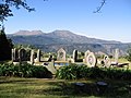
The Linville Gorge Wilderness is the third largest wilderness area in North Carolina and one of only two wilderness gorges in the Southern United States. Maintained by the United States Forest Service, it comprises 11,786 acres (47.7 km2) around the Linville River, and is situated inside the Pisgah National Forest. The river is approximately 1,400 feet below the ridge, thus hiking in and out of the Gorge is challenging and enjoyable for those who like serious hiking. The plant and animal community is extremely diverse, with a dense hardwood/pine forest and a wide variety of smaller trees and other plants as well as bear, fox, raccoon, trout, grouse, wild turkey, vultures, owls, hawks, copperheads, and timber rattlesnakes.

<span class="mw-page-title-main">Vogel State Park</span> State park in Blairsville, Georgia, USA

Vogel State Park is a 233-acre (0.94 km2) or 94 hectares state park located at the base of Blood Mountain in the Chattahoochee National Forest. It became one of the first two parks in Georgia when it founded a state park system in 1931. Much of the park was constructed by the Civilian Conservation Corps during the 1930s.

<span class="mw-page-title-main">Kaaterskill Falls</span> Waterfall in New York, United States

Kaaterskill Falls is a two-stage waterfall on Spruce Creek in the eastern Catskill Mountains of New York, between the hamlets of Haines Falls and Palenville in Greene County. The two cascades total 260 feet in height, making Kaaterskill Falls one of the highest waterfalls in New York, and one of the Eastern United States' tallest waterfalls.

<span class="mw-page-title-main">Chapel Brook</span> River

Chapel Brook of Franklin County, Massachusetts is a tributary of the South River and the name of a 173-acre (70 ha) open space preserve located along the brook. The brook, est. 3.79 mi (6.10 km) long, is located in southeast Ashfield and southwest Conway. It drains into Poland Brook, thence into the South River, the Deerfield River, the Connecticut River, and Long Island Sound. The Chapel Brook reservation, managed by the non-profit conservation organization The Trustees of Reservations, is located in Ashfield and contains Chapel Falls, a series of three waterfalls on Chapel Brook, measuring 10 feet (3.0 m), 15 feet (4.6 m) and 20 feet (6.1 m) high; and Pony Mountain est. 1,400 feet (430 m), a 100-foot (30 m) open granite cliff face and popular recreational rock climbing site.

<span class="mw-page-title-main">Platres</span> Village in Limassol, Cyprus

Platres or Pano Platres, is a Μountainous village in Cyprus. It is located on the southern slopes of the Troodos Mountains and is one of the wine villages. Platres is the largest Troodos resort, situated about 5km from Troodos Square, 25 kilometers (16 mi) north-west of Limassol and 45 kilometers (28 mi) south-west of the capital Nicosia. Platres is a very old village and is mentioned among the 119 villages of the Limassol district that existed during the Lusignan Era and the Venetian Era. Platres is the principal hill resort of Cyprus. The town has a resident population of fewer than 300, but this can swell to 10,000 during tourist seasons.

<span class="mw-page-title-main">Aulus-les-Bains</span> Commune in Occitanie, France

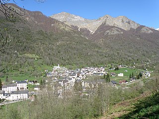
Aulus-les-Bains is a commune in the Ariège department in the Occitanie region of south-western France.

<span class="mw-page-title-main">Sir Lowry's Pass</span> Mountain pass in Western Cape, South Africa

Sir Lowry's Pass is a mountain pass on the N2 national road in the Western Cape province of South Africa. It crosses the Hottentots Holland Mountains between Somerset West and the Elgin valley, on the main route between Cape Town and the Garden Route. A railway line also crosses the mountain range near this point.

<span class="mw-page-title-main">Udzungwa Mountains National Park</span> National park in Tanzania, Africa

Udzungwa Mountains National Park is a national park in Tanzania with a size of 1,990 km2. The habitats contained within the national park include tropical rainforest, mountain forest, miombo woodland, grassland and steppe. There is a vertical height range of 250–2,576 metres, which incorporates the Udzungwa Mountains part of the Eastern Arc Mountains. There are more than 400 bird species, 2500 plant species and 6 primate species. It has the second largest biodiversity of a national park in Africa.

Mpofu Nature Reserve is a nature reserve in the Amatole district of the Eastern Cape Province, South Africa that is managed by Eastern Cape Parks.

<span class="mw-page-title-main">Paugussett Trail</span>

The Paugussett Trail is a 14-mile (23 km) Blue-Blazed hiking trail "system" in the lower Housatonic River valley in Fairfield County and, today, is entirely in Shelton and Monroe, Connecticut. Much of the trail is in Indian Well State Park and the Town of Monroe's Webb Mountain Park. The mainline trail is primarily southeast to northwest with three short side or spur trails.

<span class="mw-page-title-main">Diana's Baths</span> Waterfalls in New Hampshire, United States

Diana's Baths is a series of small waterfalls located in the southeastern corner of the town of Bartlett, New Hampshire, near the village of North Conway in the White Mountains of New Hampshire, United States. This historic site is within the White Mountain National Forest. The stream that flows into this waterfall is called Lucy Brook. The waterfalls were once the location of an old sawmill operation in the 1800s. After the sawmill was abandoned by the Lucy family in the 1940s, it was turned into a historic site that would be protected by the U.S. Forest Service. The total drop of the waterfalls is 75 feet (23 m), and the hike to the base of the waterfall is about 0.6 miles (1.0 km). Diana's Baths is now a popular family destination.

<span class="mw-page-title-main">Bridal Veil Falls (Sabie)</span>

The Bridal Veil Falls is six kilometres outside Sabie, Mpumalanga in South Africa. It is 70 metres high. The falls is slow flowing under normal conditions making it appear like a veil, hence its name. It is one of many waterfalls in the area that is located on the Sabie River and is a popular tourist destination. It is accessible by car, with parking and a picnic area on SAFCOL's grounds. Local curio dealers sell arts and crafts from the car park area. From the car park, a footpath runs through indigenous forest for about 750 metres directly to the waterfall.

<span class="mw-page-title-main">Caledonia Waterfalls</span> Waterfall in Platres, Cyprus

Caledonia Waterfalls or Kalidonia Waterfalls, is the Latin name given to the waterfalls discovered by a Scottish expedition visiting the Platres region of Cyprus in 1878. They were surprised by the resemblance of the waterfall with their homeland and named them Caledonia which is an ancient Latin name of Scotland.

References

  1. 1 2 3 4 "Main Place Hogsback". Census 2011.
  2. www.hogsbackinfo.co.za/history/
  3. "Home". hogsback.co.za.
  4. http://www.hogsbackcottage.com
  5. "Hogsback Visitors Guide | Hiking Trails & Walks in Hogsback".
  6. Hobbiton on Hogsback [ permanent dead link ]
  7. http://www.hogsback.co.za/features/st_patricks.htm Archived 3 January 2010 at the Wayback Machine – About St. Patrick's chapel