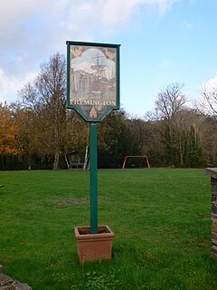
Fremington is a large village, civil parish and former manor in North Devon, England, the historic centre of which is situated three miles (5 km) west of Barnstaple. The village lies between the south bank of the tidal estuary of the River Taw and a small inlet of that river known as Fremington Pill. The parish is surrounded clockwise from the north by the parishes of Heanton Punchardon, Ashford, West Pilton, Barnstaple, Tawstock, Horwood, Lovacott and Newton Tracey, and Instow.

Bovey Tracey is a small town and civil parish in Devon, England, on the edge of Dartmoor, its proximity to which gives rise to the "slogan" used on the town's boundary signs, "The Gateway to the Moor". It is often known locally as "Bovey". It is about 10 miles south-west of Exeter and lies on the A382 road, about halfway between Newton Abbot and Moretonhampstead. The village is at the centre of the electoral ward of Bovey. At the 2011 census the population of this ward was 7,721.

Alverdiscott is a village, civil parish, former manor and former ecclesiastical parish in the Torridge district of Devon, centred 5.5 miles (9 km) SSW of Barnstaple.

Toft Newton is a civil parish in the West Lindsey district of Lincolnshire, England. It consists of the small villages of Toft next Newton and Newton by Toft, and the hamlet of Newtoft. It is 4 miles (6 km) west from Market Rasen. According to the 2001 Census it had a population of 522, decreasing to 457 at the 2011 census.

Lapford is a village and civil parish in Mid Devon in the English county of Devon. It had a population of 993 in 2001, reducing to 867 at the 2011 census. Lapford is part of Taw Valley ward whose population at the above census was 1,629.

Tawstock is a village, civil parish and former manor in North Devon in the English county of Devon, England. The parish is surrounded clockwise from the north by the parishes of Barnstaple, Bishop's Tawton, Atherington, Yarnscombe, Horwood, Lovacott and Newton Tracey and Fremington. In 2001 it had a population of 2,093. The estimated population in June 2019 was 2,372.
Mumby is a village in the East Lindsey district of Lincolnshire, England. It is located 4 miles (6 km) south-east from the town of Alford. In 2001 the population was recorded as 352, increasing to 447 at the 2011 Census.

Huntshaw is a village and civil parish located 2.5 north north east of Great Torrington, in the Torridge district, in the county of Devon, England.
The hundred of Fremington was the name of one of thirty two ancient administrative units of Devon, England.

Weston is a village and civil parish in the South Holland district of Lincolnshire, England. It is situated approximately 2 miles (3 km) north-east from the town of Spalding. The Civil Parish also includes Weston Hills. The population of the civil parish including Austendike was at the 2011 census 2,054.
Horwood is a village and former civil parish in North Devon district, in the county of Devon, England, situated about 4 miles east of the town of Bideford. It is now in the civil parish of Horwood, Lovacott and Newton Tracey. In 1961 the civil parish had a population of 79.

Preston Patrick is a village and civil parish in South Lakeland, Cumbria, England. It has junction 36 of the M6 motorway in its south west corner and extends north east on both sides of the motorway until just beyond the B2564 road. In the 2011 census its population was reported to be 426. The neighbouring parishes are Old Hutton and Holmescales to the north, Lupton to the east, Beetham to the south and Preston Richard to the west.

Irton with Santon is a civil parish in Copeland, Cumbria, England, which includes the village of Santon Bridge. It has a parish council. In the 2011 census it was recorded as having a population of 316.

Chittlehamholt is a village and civil parish in North Devon district, Devon, England. In the 2011 census it was recorded as having a population of 169.

George Nympton or Nymet St George is a small village and civil parish in North Devon district, Devon, England. In the 2011 census it was recorded as having a population of 175.

Satterleigh and Warkleigh is a civil parish in North Devon district, Devon, England. In the 2011 census it was recorded as having a population of 170.

Rose Ash, formerly Ralph-Esse, is a village and civil parish in North Devon district, Devon, England. In the 2011 census it was recorded as having a population of 298.

Martinhoe is a small settlement and civil parish in North Devon district of Devon, England. Martinhoe is within the Exmoor National Park, the smallest National Park in England. In the 2011 census Martinhoe Parish was recorded as having a population of 159. Martinhoe is in the Combe Martin ward, for elections to the district council. Martinhoe's local government takes the form of a parish meeting and as such has no parish council nor elected parish councillors.

