Monkleigh

Last updated

Monkleigh
Monkleigh - across the fields - geograph.org.uk - 667182.jpg
Monkleigh
Devon UK location map.svg
Red pog.svg
Monkleigh
Location within Devon
OS grid reference SS4520
District
Shire county
Region
Country England
Sovereign state United Kingdom
Post town MONKLEIGH
Postcode district EX39
Dialling code 01805
Police Devon and Cornwall
Fire Devon and Somerset
Ambulance South Western
UK Parliament
List of places
UK
England
Devon
50°57′45″N4°12′01″W / 50.9626°N 4.20036°W / 50.9626; -4.20036

Monkleigh is a village, parish and former manor in north Devon, England, situated 2 1/2 miles north-west of Great Torrington and 3 1/2 miles south-east of Bideford. An electoral ward exists titled Monkleigh and Littleham. The population at the 2011 census was 1,488. [1]

Contents

Etymology

The name of the village, Monkleigh, originates from the Old English "Munckenelegh", used in 1244 to describe a "wood or clearing of the monks", referring to a 12th-century property owned by the Montacute Priory. The area was previously named "Lega" in the Domesday Book of 1086. [2]

Description

In 1887, John Bartholomew, Gazetteer of the British Isles, described Monkleigh as a village and a parish. It had a population of 540 people, covered 2177 acres, and had property that belonged to the Montacute monastery. [3] It includes the hamlets of Saltern Cottages (also known as Annery Cottages) and Annery kilns, [4] both of which are historic listed sites. [5] Located west of the River Torridge valley, the village sits on high ground with scenic views of the parish. It was originally part of the Shebbear Hundred and is within the Church of England's Deanery of Hartland. [6]

History

Monastery

William, Count of Mortain, the founder of the Montacute Priory, gave the Monkleigh manor to the priory during the reign of Henry I (1100–1135). [7] [8] It was owned by the Montacute Priory [9] in Somerset until the Dissolution of the Monasteries (between 1536 and 1541). [10]

Monkleigh manor

When the monasteries were dissolved, the manor was granted by the crown gratis on 26 August 1540 to James and Anne Coffyn (also Coffin) of Alwington for the term of her life. [10] [nb 1] Anne was the widow of Sir George St Ledger of Annery. [10] In June 1544, the crown granted the manor of Monkleigh to Sir John Fulford of Dunsford and Humphrey Colles of Barton, Somerset, who paid the purchase price for the manor and obtained royal licence to alienate [lower-alpha 1] to James Coffyn. [10] [nb 2] In other words, the manor was purchased for the Coffyns. [9]

In 1810 the manor of Monkleigh was owned by Rev. John Pine-Coffin of Portledge, Alwington, from the same family as James Coffyn. [12] About 1823 Richard Pine-Coffin sold Monkleigh manor land to John Rolle, 1st Baron Rolle for the development of the Rolle Canal. [13]

Gatehouse to the now demolished Annery estate Gatehouse to Annery - geograph.org.uk - 571952.jpg
Gatehouse to the now demolished Annery estate

Annery, historic estate

The former historic estate of Annery was a neo-Classical mansion house that stood in a "fine timbered park" dating back to the 13th century or before. [6] [14] An early owner was Osbert of Annery. [9] By 1260 the house was owned by the Stapeldons; Walter de Stapeldon was born in the Annery that year and later became the Bishop of Exeter from 1307 to 1326 and Edward II's Lord High Treasurer. [6] After the Stapeldons, it was owned by Sir William Hankford. [9] The Annery fell into decay and in 1800 a new building was built on the grounds of the medieval building. [14] [15] [nb 3] It was demolished in 1957. [14]

The ruins of the lime Annery kiln, built about 1823–1824 for Lord Rolle, are located along the River Torridge. Limestone was brought from Caldy Island and Gower Peninsula. [16]

Church of St George

St George's Church, Monkleigh Monkleigh Church - geograph.org.uk - 81999.jpg
St George's Church, Monkleigh

In the early 15th century [17] parish church is dedicated to St George. [18] Sir William Hankford, Chief Justice of the King's Bench, left monies for the church to complete construction of the south aisle in his will. He stipulated that the south aisle should be reserved for his and his heirs burial. Hankford died in 1423; at that time the fabric was being rebuilt. Hankford was buried in a canopied alter-tomb. [6]

The Annery aisle has bench-ends decorated with the arms of the Annery manor families and emblems of the Passion. Tiles from the late medieval period are found in the aisle and the nave. A kneeling effigy of James Coffin, Esquire (1566) in armour sat on a high tomb and was since destroyed. [6] Pevsner stated that a small monumental brass of a kneeling knight, affixed to a stone tablet, and with heraldic escutcheons of the arms of Coffin, is dated from the 16th century. [18] [19] Sir James St. Leger (1509) is represented in brass. [6]

From 1862 to 1863 the church was restored. [6] According to Pevsner, it contains one of the most remarkable medieval wooden screens in Devon; [18] It is a detailed parclose screen that may date to 1537 when Dame Anne St. Leger founded a chantry in the chapel. [6]

Other historic buildings

Some of the other historic buildings in Monkleigh include the early 19th century Monkleigh Millhouse; [20] an early 19th-century country house, Petticombe Manor; [21] Rudha Bridge Millhouse; [22] The Bell Inn, originally built in the 17th century; [23] and farmhouses, cottages, outbuildings, and bridges. [5]

Transportation

Roads

Monkleigh is served by A388 road. [24]

Ferry

A ferry operates between Bideford quay and Lundy Island, which lies about 22 miles (35 km) away in the Bristol Channel. The same ship, the MS Oldenburg, also provides evening cruises from Bideford along the River Torridge. [25]

Bus

There are several bus services provided by Stagecoach Devon, Carmel Coaches and Jackett bus services as of May 2013, including: [26]

Railway

The nearest railway stations are at Umberleigh, Chapelton and Barnstaple. [27]

Airports

The nearest airports for public transportation are Eaglescott Airfield and Exeter International Airport. [28]

Education

Monkleigh Primary School conducts 3 mixed age classes within the town of Monkleigh. [29]

Other nearby schools are Langtree Community School And Nursery Unit, East-The-Water Community Primary School, Buckland Brewer Community Primary School, Pynes Infant School And Nursery and West Croft Junior School. [30]

Notable people

Notes

  1. It was valued at £21 11s 6d per annum, but unusually no charge was made for the grant. [10]
  2. On 11 June 1544 the crown granted the manor of Monkleigh, subject to the life interest of Coffyn's wife, to Sir John Fulford of Dunsford and Humphrey Colles of Barton, Somerset, along with other grants of property. For Monkleigh manor they were charged £194 3s 4d, representing 10 years' purchase of its annual value. They were also granted Monkleigh Woods for £29 13s 6d, representing 20 years' purchase [10] Fulford and Coles paid the purchase price in full on 2 June 1544 and just one week later obtained royal licence to alienate, to James Coffyn of Alwington. [10]
  3. It has also been said that the building was modernised and refurbished. [6]
  1. The British Records Association's definition of "licence to alienate" is "royal permission, by Letters patent, to sell or dispose of a property obtained from the Crown and held by knight service." [11]

Sources

Related Research Articles

<span class="mw-page-title-main">Bideford</span> Town in Devon, England

Bideford is a historic port town on the estuary of the River Torridge in north Devon, south-west England. It is the main town of the Torridge local government district.

<span class="mw-page-title-main">Langtree</span> Village and civil parish in Devon, England

Langtree is a village and parish in north Devon, England, situated about 4 miles (6 km) south-west of Great Torrington and 8 miles (13 km) south of Bideford. Its name means "tall tree". Torridge District Council and Devon County Council are responsible for local government, while for religious administrative purposes it is part of the Archdeaconry of Barnstaple and the Diocese of Exeter. In 2021 the parish had a population of 837.

<span class="mw-page-title-main">Abbots Bickington</span> Village in Devon, England

Abbots Bickington is a village and civil parish in the English county of Devon, located 7.7 mi (12.4 km) north-northeast of Holsworthy and near the River Torridge.

<span class="mw-page-title-main">Pilton, Devon</span> Suburb within the town of Barnstaple

Pilton is a suburb of the town of Barnstaple, it is located about quarter of a mile north of the town centre, in the civil parish of Barnstaple, in the North Devon district, in the county of Devon, England. It was formerly a separate village. The civil parish of Pilton West covers the more rural parts of the ancient parish of Pilton that have not been incorporated into the town of Barnstaple. In 2009, the Pilton (Barnstaple) ward had a population of 4,239 living in some 1,959 dwellings. It has its own infants and junior school, houses one of Barnstaple's larger secondary schools, and one of Barnstaple's SEN specialist schools. North Devon Hospital is also within West Pilton parish. It has a Church Hall, two public houses, two hotels, and residential homes. It has residential estates of both private and public housing including flats. It also has a historic Church that dates back to at least the 11th Century.

<span class="mw-page-title-main">Alwington</span> Village in Devon, England

Alwington is a village and civil parish in the Torridge district of Devon, England. The parish is on the coast and includes the hamlets of Alwington, Fairy Cross, Ford, Knotty Corner and Woodtown. The parish has a total population of 381, increasing at the 2011 census to 400.

<span class="mw-page-title-main">River Torridge</span> River in Devon, England

The River Torridge is a river in Devon in England; it rises near Meddon. The river describes a long loop through Devon farming country where its tributaries the Lew and Okement join before meeting the Taw at Appledore and flowing into the Bristol Channel. The river is spate dependent and often flows between wooded banks which can be steep. The Torridge local government district is named after the river.

<span class="mw-page-title-main">Parkham</span> Village in Devon, England

Parkham is a small village, civil parish and former manor situated 5 miles south-west of the town of Bideford in north Devon, England. The parish, which lies within the Kenwith ward in the Torridge district, is surrounded clockwise from the north by the parishes of Alwington, Littleham, Buckland Brewer, East Putford and Woolfardisworthy. In 2001 its population was 742, compared to 786 in 1901.

<span class="mw-page-title-main">Annery kiln</span>

Annery kiln is a former limekiln of the estate of Annery, in the parish of Monkleigh, North Devon. It is situated on the left bank of the River Torridge near Half-Penny Bridge, built in 1835, which connects the parishes of Monkleigh and Weare Giffard. Running by it today is A386 road from Bideford to Great Torrington. Weare Giffard is the start of the tidal section of the River Torridge, and thus the kiln was sited here to import by river raw materials for the kiln, the product of which was lime fertiliser for use on inland agricultural fields. The old lime kiln is thus situated between the River Torridge and the now filled-in Rolle Canal built circa 1827 and railway that ran formerly from Bideford to Torrington, opened in 1872 and closed in 1966. The old trackbed now forms a stretch of the Tarka Trail.

<span class="mw-page-title-main">William Hankford</span> English lawyer

t

Milton Damerel is a village, parish and former manor in north Devon, England. Situated in the political division of Torridge, on the river Waldon, it covers 7 square miles (18 km2). It contains many tiny hamlets including Whitebeare, Strawberry Bank, East Wonford and West Wonford. The parish has a population of about 450. The village is situated about 5 miles (8.0 km) from Holsworthy, 13.081 miles (21.052 km) from Bideford and 22.642 miles (36.439 km) from Barnstaple. The A388 is the main road through the parish.

Henry Squire was an English poet and clergyman, and Archdeacon of Barnstaple from 1554 to 1582.

<span class="mw-page-title-main">Weare Giffard</span> Village, civil parish and former manor in Devon, England

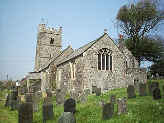
Weare Giffard is a small village, civil parish and former manor in the Torridge district, in north Devon, England. The church and manor house are situated 2 1/2 miles NW of Great Torrington in Devon. Most of the houses within the parish are situated some 1/2-mile east of the church. The church is situated on a hillside to the north and slightly above the wide and flat valley floor of the River Torridge. The Church of the Holy Trinity and the adjacent Weare Giffard Hall are designated members of the Grade I listed buildings in Devon. In 2011 the parish had a population of 345.

<span class="mw-page-title-main">George Rolle</span> Member of the Parliament of England

George Rolle of Stevenstone in the parish of St Giles in the Wood near Great Torrington in Devon, was the founder of the wealthy, influential and widespread Rolle family of Devon, which according to the Return of Owners of Land, 1873 in the person of Hon. Mark Rolle, the adoptive heir of John Rolle, 1st Baron Rolle, had become by that year the largest landowner in Devon with about 55,000 acres. He was a Dorset-born London lawyer who in 1507 became Keeper of the Records of the Court of Common Pleas and was elected as a Member of Parliament for Barnstaple in 1542 and 1545. He became the steward of Dunkeswell Abbey in Devon, and following the Dissolution of the Monasteries he purchased much ex-monastic land in Devon. Not only was he the founder of his own great Devonshire landowning dynasty but he was also an ancestor of others almost as great, including the Acland baronets of Killerton, the Wrey Baronets of Tawstock and the Trefusis family of Trefusis in Cornwall now of Heanton Satchville, Huish, later Baron Clinton, heirs both of Rolle of Heanton Satchville, Petrockstowe and of Rolle of Stevenstone.

<span class="mw-page-title-main">Beam, Great Torrington</span> Historic estate in Devon, England

Beam is an historic estate in the parish of Great Torrington, Devon, England. Beam House is situated about 1 1/2 miles north-west and downstream of that town, on the right-bank of the River Torridge. Both the Rolle Canal and the railway crossed the river nearby. It occupies a particularly beautiful setting, described by Lauder (1986) thus: "For lovers of rivers and woodland there can be few lovlier settings for a house than this. Steeply wooded banks shelter the valley and the house is situated on slightly higher ground above lush water meadows, almost completely surrounded by the Torridge" The estate was a subsidiary seat of the Rolle family, lords of the manor of Great Torrington, whose main seat was Stevenstone on the other (south) side of that town and therefore upstream from Beam. It was an outpost of the Royalists during the Civil War. Much of the estate is today owned by Baron Clinton, as heir to the Rolles, but it has had many occupants, including use by the army in both world wars and as a borstal. Tarka the Otter was born at Beam, by what the author Henry Williamson called the "Canal Bridge" and particularly favoured the River Torridge at Beam Weir. Thus the cycleway which crosses the river at Beam, formerly the railway line, was named the "Tarka Trail", due to its association with these and other haunts of the fictional animal. Today Beam is used as an adventure centre for young people.

<span class="mw-page-title-main">Annery, Monkleigh</span> Historic estate in Devon, England

Annery was an historic estate in the parish of Monkleigh, North Devon.

<span class="mw-page-title-main">Manor of Monkleigh</span>

The Manor of Monkleigh was a mediaeval manor centred on the village of Monkleigh in North Devon, England, situated 2 1/2 miles north-west of Great Torrington and 3 1/2 miles south-east of Bideford.

<span class="mw-page-title-main">Joseph Prust</span>

Joseph Prust (1620–1677) of Annery, in the parish of Monkleigh, Devon, was a royalist military commander during the Civil War. He was a lieutenant colonel.

<span class="mw-page-title-main">Bideford Long Bridge</span> Bridge in Devon, England

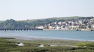
Bideford Long Bridge in North Devon spans the River Torridge near its estuary and connects the old part of the town, and formerly important river port, of Bideford on the left bank with East-the-Water on the right bank. It is one of the longest mediaeval bridges in England, being 677 feet long with 24 arches. In 1790 the bridge was the longest in Devon. It remained the furthest downstream bridge on the river until 1987, when the Torridge A39 Road Bridge was built a mile or so further downstream at Northam. The river is still tidal at Bideford and a very large fluctuation in water levels occurs twice daily under the bridge. An ancient New Year's Eve tradition was to try to run across the Long Bridge during the time taken for the bells of St. Mary's parish church, near the west end, to chime midnight. A sight enjoyed by many in the winter months is of the starlings at dusk, as they come in large flocks to roost underneath the bridge.

<span class="mw-page-title-main">Richard Bampfield</span>

Richard Bampfield (1526–1594) of Poltimore and Bampfylde House in Exeter, both in Devon, was Sheriff of Devon in 1576. He began construction of the Tudor era Poltimore House in 1550, and completed the building of Bampfylde House, Exeter, along with The Great House, Bristol one of the finest Elizabethan townhouses in the West Country, in 1590. He is the ancestor of the Bampfylde Baronets and Barons Poltimore.

<span class="mw-page-title-main">Richard Coffin (1623–1700)</span>

Richard Coffin (1623–1700) of Portledge in the parish of Alwington in North Devon, was lord of the manor of Alwington and served as Sheriff of Devon in 1683.

References

  1. "Ward population" . Retrieved 16 February 2015.
  2. A. D. Mills (9 October 2003). A Dictionary of British Place-Names. Oxford University Press. p. 503. ISBN   978-0-19-157847-2 . Retrieved 23 June 2013.
  3. "Descriptive Gazetteer Entry for Monkleigh". Vision of Britain. Retrieved 23 June 2013.
  4. William White (of Sheffield.) (1879). History, Gazetteer and Directory of the County of Devon: Including the City of Exeter, and Comprising a General Survey of the County ... White. p. 550. Retrieved 24 June 2013.
  5. 1 2 "Listed Buildings in Monkleigh, Devon, England". British Listed Buildings. Retrieved 24 June 2013.
  6. 1 2 3 4 5 6 7 8 9 "Monkleigh". Devon County Council. Archived from the original on 15 March 2015. Retrieved 23 June 2013.
  7. Daniel and Samuel Lysons (1822). "Parishes: Maker – Musbury". Magna Britannia: volume 6 Devonshire. pp. 326–360. Retrieved 24 June 2013.
  8. Richard Nicholls Worth (1895). A history of Devonshire: With sketches of its leading worthies. E. Stock. p. 158. Retrieved 24 June 2013.
  9. 1 2 3 4 Tristram Risdon (1811). The chorographical description or survey of the county of Devon: Printed from a genuine copy of the original manuscript, with considerable additions. Printed for Rees and Curtis, Plymouth. pp. 276–277. Retrieved 23 June 2013.
  10. 1 2 3 4 5 6 7 Gt. Brit. Court of Augmentations; Joyce A. Youings (Ed) (1955). Devon Monastic Lands; Calendar of Particulars for Grants 1536–1558. pp. 39–41.
  11. "How To Interpret Deeds – A Simple Guide And Glossary". British Records Association. Archived from the original on 2 October 2013. Retrieved 23 June 2013.
  12. Risdon, Tristram. Survey of Devon, 1810 Additions. p. 422.
  13. Scrutton, Susan (2006). Lord Rolle's Canal, Great Torrington. p. 30. ASIN   B005E8QSKY.
  14. 1 2 3 Historic England. "Annery House (1105127)". National Heritage List for England . Retrieved 24 June 2013.
  15. "Annery House" (PDF). Archaeology Data Service. 2 March 2006. Retrieved 24 June 2013.
  16. "Annery Kiln". British Listed Buildings. Retrieved 24 June 2013.
  17. "Church of St George". British Listed Buildings. Retrieved 24 June 2013.
  18. 1 2 3 Pevsner, Nikolaus; Cherry, Bridget (2004). 'The Buildings of England: Devon. p. 573.
  19. Vivian, Lt.Col. J.L., ed. (1895). The Visitations of the County of Devon: Comprising the Heralds' Visitations of 1531, 1564 & 1620. Exeter. p. 208.{{cite book}}: CS1 maint: location missing publisher (link)
  20. "Monkleigh Millhouse". British Listed Buildings. Retrieved 24 June 2013.
  21. "Petticombe Manor". British Listed Buildings. Retrieved 24 June 2013.
  22. "Rudha Bridge Millhouse". British Listed Buildings. Retrieved 24 June 2013.
  23. "The Bell Inn". British Listed Buildings. Retrieved 24 June 2013.
  24. "Google maps – Monkleigh, UK". Google Maps. Retrieved 24 June 2013.
  25. "MS Oldenburg". Lundy Island. Retrieved 24 June 2013.
  26. "List of Transport Services from Monkleigh". Carlberry – Travel Search. Retrieved 24 June 2013.
  27. "Maps – Station Finder – Monkleigh". The Train Line. Retrieved 24 June 2013.
  28. "Monkleigh nearest airports". virtualtenby.co.uk. Retrieved 24 June 2013.
  29. "About the school". Monkleigh Primary School. Retrieved 24 June 2013.
  30. "Monkleigh Primary School – Other nearby schools". Classdojo.com. Archived from the original on 28 June 2013. Retrieved 24 June 2013.

Commons-logo.svg Media related to Monkleigh at Wikimedia Commons