Princetown is a village in the Dartmoor national park in the English county of Devon. It is the principal settlement of the civil parish of Dartmoor Forest.
Okehampton is a town and civil parish in West Devon in the English county of Devon. It is situated at the northern edge of Dartmoor, and had a population of 5,922 at the 2011 census. Two electoral wards are based in the town. Their joint population at the same census was 7,500.

Moretonhampstead is a market town, parish and ancient manor in Devon, situated on the north-eastern edge of Dartmoor, within the Dartmoor National Park. The parish now includes the hamlet of Doccombe, and it is surrounded clockwise from the north by the parishes of Drewsteignton, Dunsford, Bridford, Bovey Tracey, Lustleigh, North Bovey and Chagford.
Lydford, sometimes spelled Lidford, is a village, once an important town, in Devon, seven miles (11 km) north of Tavistock on the western fringe of Dartmoor in the West Devon district. There is an electoral ward with the same name which includes Princetown. The population of this ward at the 2011 census was 2,047.

Belstone is a small village and civil parish in the West Devon District of Devon, England. Lying on the northern side of Dartmoor, the western boundary of the parish is mostly formed by the East Okement River and the eastern by the River Taw; its highest point is Belstone Tor in the south, at 1,508 feet. The parish is surrounded, clockwise from the north, by the parishes of Sticklepath, South Tawton, Dartmoor Forest and Okehampton Hamlets. In 2001 its population was 257, relatively unchanged from the 1901 figure of 236.

Torridge and West Devon is a constituency represented in the House of Commons of the UK Parliament since 2005 by Geoffrey Cox, a Conservative.

Copplestone is a village, former manor and civil parish in Mid Devon in the English county of Devon. It is not an ecclesiastical parish as it has no church of its own, which reflects its status as a relatively recent settlement which grew up around the ancient "Copleston Cross" that stands at the junction of the three ancient ecclesiastical parishes of Colebrooke, Crediton and Down St Mary.

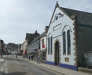
Bridestowe is a civil parish and village in the district of West Devon, Devon, England. The parish is surrounded clockwise from the north by the parishes of Bratton Clovelly, Sourton, Bridestowe and Sourton Common, Lydford, Lewtrenchard and Thrushelton.

The River Lew can refer to either of two short rivers that lie close to each other in Devon, England.

Gidleigh is a village and civil parish in the West Devon district of Devon, England. Located within Dartmoor National Park, the parish is surrounded clockwise from the north by the parishes of Throwleigh, Chagford and Dartmoor Forest. In 2001 its population was 116, little changed from 114 in 1901.
Sourton is a small village and civil parish in West Devon, England. It lies about 4 miles (6.4 km) south-west of Okehampton. It is at the north-western extremity of Dartmoor, a National Park of England and Wales, and lies along the A386 road. The historic map of Sourton shows that it is located near a river and the Sourton forest this can be seen in the image below.
Dartmoor Forest is a civil parish in Devon, England. It was formed in 1987 by the splitting of the former parish of Lydford. It covers about 56,000 acres (230 km2) entirely within Dartmoor National Park, and is the largest parish in Devon. Despite its size its population in 2001 was only 1,619. Due to its large size it is surrounded by many other parishes: these are, clockwise from the north, Belstone, South Tawton, Throwleigh, Gidleigh, Chagford, North Bovey, Manaton, Widecombe in the Moor, Holne, West Buckfastleigh, Dean Prior, South Brent, Ugborough, Harford, Cornwood, Shaugh Prior, Sheepstor, Walkhampton, Whitchurch, Peter Tavy, Lydford, land common to the parishes of Bridestowe and Sourton, and Okehampton Hamlets.

Dendles Wood is an area of protected oak-beech woodland located on the southern edge of Dartmoor, in the English county of Devon. Forming part of the Dartmoor Special Area of Conservation, the wood is also a Site of Special Scientific Interest, and 30 hectares of it has been designated a national nature reserve. It is one of five woodlands within Dartmoor that have been protected as national nature reserves. Dendles Wood and the adjacent Hawns Wood are sometimes known collectively as Hawns and Dendles. The wood supports a variety of flora and fauna, representative of upland oakwoods. In particular, it has a rich variety of moss and lichen, and several breeding bird species.
Lifton Hundred was the name of one of thirty two ancient administrative units of Devon, England.

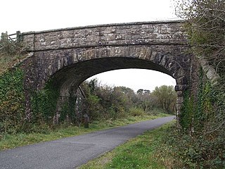
Bridestowe railway station served the 2 miles or so distant village of Bridestowe in West Devon, England, located outside Okehampton on the edge of Dartmoor.

West Buckfastleigh is a small civil parish on the eastern border of Dartmoor in Devon, England. Situated within the parish are the village of Scorriton and the hamlets of Michelcombe and Combe.

Thrushelton or Thruselton is a village and civil parish about 2 and a half miles north of Coryton railway station, in the West Devon district, in the county of Devon, England. In 2011 the parish had a population of 197. The parish touches Bratton Clovelly, Bridestowe, Lewtrenchard, Stowford, Broadwoodwidger, Marystow and Germansweek.

Newton Poppleford and Harpford is a civil parish in East Devon, England. It is surrounded clockwise from the north by the parishes of Ottery St Mary, Sidmouth, Otterton, Colaton Raleigh and Aylesbeare. The parish includes the large village of Newton Poppleford, and also includes the smaller settlements of Harpford, Burrow, Southerton and Venn Ottery. As of 2019, it has a population of 2,153.
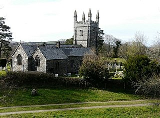
St Bridget's Church in Bridestowe, Devon, is a parish church in the Church of England and one of the central buildings in the rural area on the northwestern edge of Dartmoor. It is a Grade II* listed building of medieval construction with restorations made in the 19th century.

