
The Diocese of Truro is a Church of England diocese in the Province of Canterbury which covers Cornwall, the Isles of Scilly and a small part of Devon. The bishop's seat is at Truro Cathedral.

Altarnun is a village and civil parish in Cornwall, England, United Kingdom. It is located 7 miles (11 km) west of Launceston on the north-eastern edge of Bodmin Moor at grid reference SX 223 811.
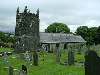
Warbstow is a village and civil parish in Cornwall, England, United Kingdom. The parish has a population of 439 according to the 2001 census, increasing to 520 at the 2011 census.

St Issey is a civil parish and village in Cornwall, England, United Kingdom which lies approximately two miles (3 km) south of Padstow. The parish covers an area of approximately 4,500 acres (18 km2). At the 2011 census the parish population was 940. An electoral ward with the name of St Issey also existed before being replaced by St Issey and St Tudy in 2013. Its population at the same census was 4,111.

Boyton is a civil parish and village in Cornwall, England, United Kingdom. It is situated close to the River Tamar and the border with Devon about six miles (10 km) north of Launceston. According to the 2001 census it had a population of 378.This increased to 457 at the 2011 census.

Broadwoodwidger is a village and civil parish in the Torridge district of Devon, England. According to the 2001 census it had a population of 548. The village is just to the north of the A30 road, and is about eight miles east of Launceston in Cornwall, and 13 miles west of Okehampton. Roadford Reservoir, which is also called Roadford Lake, is to the north-east of the village, and the River Wolf passes at the bottom of the hillside on which the village stands.
Broadwoodwidger was a rural district in the administrative county of Devon from 1894 to 1966, northeast of Launceston. The district consisted of part of the Launceston rural sanitary district in Devon. The remainder of the sanitary district became Launceston Rural District in Cornwall.

St Enoder is a civil parish and hamlet in Cornwall, England, United Kingdom. The hamlet is situated five miles (8 km) southeast of Newquay. There is an electoral ward bearing this name which includes St Columb Road. The population at the 2011 census was 4,563.

Kea is a civil parish and village in Cornwall, England, United Kingdom. It is a "large straggling parish" in a former mining area south of Truro.

Sithney is a village and civil parish in the West of Cornwall, England, United Kingdom. Sithney is north of Porthleven. The population including Boscadjack and Crowntown at the 2011 census was 841.
Laneast is a village and civil parish in Cornwall, England, United Kingdom. It lies above the River Inny valley, about six miles (11 km) west of Launceston. The population in the 2001 census was 164, increasing to 209 at the 2011 census.
Werrington is a civil parish and former manor now in Cornwall, England, United Kingdom. Prior to boundary changes it straddled the Tamar and lay within the county of Devon. The portion on the west side was transferred to Cornwall by the abolition of Broadwoodwidger Rural District by the Local Government Commission for England in 1966. It is situated 1 mile (1.6 km) to the west of the Tamar, the traditional boundary between Devon and Cornwall, and 1 mile (1.6 km) north of Launceston.
Linkinhorne is a civil parish and village in southeast Cornwall, England, United Kingdom. The village itself is situated at grid reference SX 320 736 and is approximately four miles (6.5 km) northwest of Callington and seven miles (11 km) south of Launceston. The parish population at the 2011 census including Downgate was 1,541

Lawhitton is a village in the civil parish of Lawhitton Rural, in east Cornwall, England, United Kingdom. The village is situated two miles (3 km) southwest of Launceston and half-a-mile west of Cornwall's border with Devon at the River Tamar.

St Stephens by Launceston Rural is a civil parish in the east of Cornwall, England, United Kingdom. It is in the Registration district of Launceston. The population of the parish in the 2001 census was 312, increasing to 360 and including Dutson at the 2011 census. The former parish of St Stephens by Launceston was abolished in 1894: St Stephens by Launceston Urban became part of the town of Launceston, while St Stephens by Launceston Rural became part of Launceston Rural District.
St Thomas the Apostle Rural, also known as St Thomas-by-Launceston is a civil parish in east Cornwall, England, United Kingdom. It is centred on the village of Tregadillett and is in the Registration District of Launceston.

Treneglos is a hamlet and a civil parish in north-east Cornwall, England, United Kingdom. It is in the Registration District of Launceston.
Christianity in Cornwall began in the 4th or 5th century AD when Western Christianity was introduced as in the rest of Roman Britain. Over time it became the official religion, superseding previous Celtic and Roman practices. Early Christianity in Cornwall was spread largely by the saints, including Saint Piran, the patron of the county. Cornwall, like other parts of Britain, is sometimes associated with the distinct collection of practices known as Celtic Christianity but was always in communion with the wider Catholic Church. The Cornish saints are commemorated in legends, churches and placenames.

Launceston is a town, ancient borough, and civil parish in Cornwall, England, United Kingdom. It is 1 mile (1.6 km) west of the middle stage of the River Tamar, which constitutes almost the entire border between Cornwall and Devon. The landscape of the town is generally steep particularly at a sharp south-western knoll topped by Launceston Castle. These gradients fall down to the River Kensey and smaller tributaries.
St Werburgh's Church, Warbstow is a Grade II* listed parish church in the Church of England in Warbstow, Cornwall.


