
Sidmouth is a town on the English Channel in Devon, South West England, 14 miles (23 km) southeast of Exeter. With a population of 12,569 in 2011, it is a tourist resort and a gateway to the Jurassic Coast World Heritage Site. A large part of the town has been designated a conservation area.
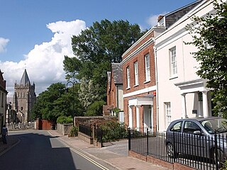
Ottery St Mary, known as "Ottery", is a town and civil parish in the East Devon district of Devon, England, on the River Otter, about 10 miles (16 km) east of Exeter on the B3174. At the 2001 census, the parish, which includes the villages of Metcombe, Fairmile, Alfington, Tipton St John, Wiggaton, and West Hill, had a population of 7,692. The population of the urban area alone at the 2011 census was 4,898.

East Devon is a local government district in Devon, England. Its council has been based in Honiton since February 2019, and the largest town is Exmouth.
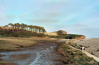
The River Otter is a river that rises in the Blackdown Hills just inside the county of Somerset, England near Otterford, then flows south through East Devon. It enters the English Channel at the western end of Lyme Bay, part of the Jurassic Coast, a UNESCO World Heritage Site. The Permian and Triassic sandstone aquifer in the Otter Valley is one of Devon's largest groundwater sources, supplying drinking water to 200,000 people.

East Devon is a constituency represented in the House of Commons of the UK Parliament since 2019 by Simon Jupp of the Conservative Party.

Cranbrook is a new town being developed in East Devon, England, which at the 2021 census, had a population of 6,741 residents across 8 "phases". However, the town is growing at a fast pace. It is located 9 kilometres east-north-east of the centre of Exeter, just north-west of the village of Rockbeare, between the B3174 road and the West of England Main Line railway. The civil parish was formed on 1 April 2015.

Bratton Fleming is a large village, civil parish and former manor near Barnstaple, in Devon, England. It lies a few miles west of Exmoor. The parish is surrounded, clockwise from the north, by the parishes of Challacombe, Brayford, Stoke Rivers, Goodleigh, Shirwell, Loxhore, Arlington and Kentisbury. The population of the parish in 2001 was 942, falling to 928 in 2011. There is an electoral ward with the same name which at the 2011 census had a population of 2,117.

Honiton was a parliamentary constituency centred on the town of Honiton in east Devon, formerly represented in the House of Commons of the Parliament of the United Kingdom. It sent members intermittently from 1300, consistently from 1640. It elected two Members of Parliament (MPs) until it was abolished in 1868. It was recreated in 1885 as a single-member constituency.
Feniton is a village and civil parish in East Devon in the English county of Devon. The village lies about 4 miles (6.4 km) west of Honiton, 3 miles (4.8 km) north of Ottery St Mary, and 2 miles (3.2 km) east of Talaton.
Newton Poppleford is a large village and former civil parish situated on the A3052 road between Exeter and Sidmouth on the west side of the River Otter, now in the parish of Newton Poppleford and Harpford in the East Devon district, in the county of Devon, England, within the East Devon AONB. Newton Poppleford is twinned with Crèvecœur-en-Auge in Normandy, France. In 2019 it had an estimated population of 1784.

Otterton is a village and civil parish in East Devon, England. The parish lies on the English Channel and is surrounded clockwise from the south by the parishes of East Budleigh, Bicton, Colaton Raleigh, Newton Poppleford and Harpford and Sidmouth. In 2001 its population was 700, compared to 622 a hundred years earlier. At the 2011 census the population had reduced to 656. Otterton is part of Raleigh electoral ward whose total population at the above census was 2,120.

Colaton Raleigh is a village and civil parish in East Devon, England. The parish is surrounded clockwise from the north by the parishes of Aylesbeare, Newton Poppleford and Harpford, Otterton, Bicton, Woodbury and a small part of Farringdon.

Gittisham is a village and civil parish in Devon near Honiton. The village is 3 miles (5 km) from Ottery St Mary and it has a church called St Michael. The parish is surrounded, clockwise from the north, by the parishes of Awliscombe, Honiton, Sidmouth, Ottery St Mary, Feniton and Buckerell.
The hundred of East Budleigh was the name of one of thirty two ancient administrative units of Devon, England.
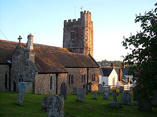
Harpford is a small village in East Devon, England. It lies on the east side of the River Otter, less than 1 mile north east of the larger village of Newton Poppleford.

Venn Ottery, historically also spelt Fen Ottery, is a small village and former civil parish, now in the parish of Newton Poppleford and Harpford, in the East Devon district, in the county of Devon, England. It lies 1 mile north of the larger village of Newton Poppleford. In 1931 the parish had a population of 66.

St Mary's Church is a Grade I listed building, a parish church in the Church of England in Ottery St Mary, Devon.

The East Devon Pebblebed Heaths is an area of rare lowland heath in east Devon, England. Lying inland of the coastal towns of Exmouth and Budleigh Salterton, it forms a north–south ridge on the western side of the River Otter at heights above sea level varying between 70 and 150 m. The main area, to the south, consists of the contiguous East Budleigh Common, Lympstone Common, Bicton Common, Woodbury Common and Colaton Raleigh Common; to the north are Hawkerland Valley, Harpford Common, Aylesbeare Common and Venn Ottery Common; and there are a few smaller nearby areas.

