Howardsville, Albemarle County, Virginia

Last updated
Howardsville
USA Virginia location map.svg
Red pog.svg
Howardsville
Location within the Commonwealth of Virginia
Usa edcp location map.svg
Red pog.svg
Howardsville
Howardsville (the United States)
Coordinates: 37°44′05″N78°38′50″W / 37.73472°N 78.64722°W / 37.73472; -78.64722 Coordinates: 37°44′05″N78°38′50″W / 37.73472°N 78.64722°W / 37.73472; -78.64722
CountryUnited States
State Virginia
County Albemarle
Time zone UTC−5 (Eastern (EST))
  Summer (DST) UTC−4 (EDT)
GNIS feature ID1495724 [1]

Howardsville is an unincorporated community in Albemarle County, Virginia. [1]

Contents

Howardsville is named after one of its principal founders, Allen Howard, who settled the northern bank of the James River at the point where the Rockfish River, its largest tributary, enters its flow. Along with other families, such as the Andersons, Jordans, Cabells and Childresses, both sides of the river were settled by people moving up from the lower James to plant new lands with tobacco and other crops in the 1730s and 1740s. The area was also known for its limestone and iron ore deposits and a forge of some sort was established in the settlement from a very early date.[ citation needed ]

History

There is a stream that flows through the community called the Mullinax, which is probably a Native American word and may denote the name of a Native American village on this site that predated European settlement. Dozens of arrowheads, spearheads, stone bowls and other Native American artifacts have been found in the area. Probably the first contact Europeans had with the area were fur traders making their way up river from village to village.

The original community consisted of several large and medium plantations, as well as a landing for bateaux poling up and down the river. More settlers rapidly settled up the Rockfish River and along both sides of the James. In the mid-18th century, a road was cut along the north bank of the James - the James River Road - and another wound up the Rockfish to meet Secretary Sands' Road, which cut through the southern part of Albemarle County.

The settlement, probably called Howard’s Landing at the time, was created prior to the founding of Albemarle County so, along with Scottsville, a little further down river, is one of the founding communities of the county. It remains unique for being almost unchanged since the mid-18th century and early 19th century, with its two original historic plantation homes, one of the earliest Masonic Lodges in the state and also one of its earliest Methodist halls. The old tobacco prizery is still there, although its upper stories were burned down by Philip Sheridan during the Civil War. The old Howardsville Bank is also there, which printed its own bank notes and was a Civil War hospital and general store for much of its history. Both buildings date from the middle 18th century.

During the American Revolution, the village was known as Irving's Store. Because of its large, secure brick warehouse, its foundry, and other secure brick buildings, as well as its central location on the James River, with roads heading both east-west and north-south, it became one of the storage depots for the Virginia Militia and several letters of the time from the major in command at Irving's Store talk of difficulties in supplying the militia with armaments because of the low level of the river and lack of boats to transport goods. The foundry would have been useful to make bayonets and repair muskets and other military equipment. It is also mentioned that British cavalry under Colonel Tarleton tried to make a raid up the river from Richmond to destroy the arms depot.

During the early years of the 19th century, the community grew into a small town. It was on a prime location at the confluence of two rivers. Soapstone had been found just up the Rockfish River and was now being mined and the local planters were growing rich on tobacco. So, when the James River and Kanawha Canal was built through the town in the 1830s, the land around the canal was divided into lots and sold off, stores were built, two mills were erected, and there was a canal boat basin - probably for minor repairs and to store boats that were not using the canal. There was a lock and an aqueduct erected over the Rockfish, and a lock-keeper's cottage was built. It is from this period that the name 'Howardsville' was first used.

Within ten years of the canal coming to the town, local investors set up the Howardsville and Rockfish Gap Turnpike Company and during the 1840s cut a road from the river over the Blue Ridge Mountains and across the Shenandoah Valley south of Staunton all the way to the Appalachians. However, the turnpike was never successful. The community went on to thrive in the 1840s and 1850s.

During the Civil War, the foundry is known to have made sabers for the Confederate cavalry and a captain of cavalry was sent to the town to supervise their production. The town also supplied Lee’s forces with food and the canal ran military supplies to his forces continuously during the war years, especially supplying Lee's army in Richmond during the last year of the war. Because of its industry and location on the canal, Union cavalry under Sheridan, which including a column led by George Custer, raided the Howardsville-Scottsville area in the spring of 1864, burning bridges, the foundry, the mills and several the houses. It burned and smashed the lock gates and aqueduct, destroyed canal boats carrying food and military supplies, raided the bank - though its gold had been secreted away just hours before the Union troops arrived – and Sheridan set up house in Monticola while his men pillaged the surrounding area. The invaders remained in the area for two-three days, raiding up and down the north bank of the James, unable to cross because the river was in spate and locals had destroyed all the bridges that crossed it. Triumphant, they eventually headed east down the river, to then turn northeast and circle Richmond to rejoin Grant's army.

The confluence of the Rockfish and James Rivers at Howardsville, showing flooding damage in the aftermath of Hurricane Camille Rockfish River at Howardsville (7797541166).jpg
The confluence of the Rockfish and James Rivers at Howardsville, showing flooding damage in the aftermath of Hurricane Camille

After the Civil War, the community struggled to regain its former glory. Although a road bridge was built over the James River about 1911 to replace the old ferry, the community continued to decline. The foundry soon closed, the mercantile business struggled, the hotels had little business and the stores began to look a dowdy and rundown.

Howardsville’s population did not grow significantly during this time, and with the general urbanization of the 1950s, the community fell into decline. Hurricane Camille traveled along the Rockfish River in 1969 and swept away all the lower town that rested along the James River; many of the stores and the hotels were already in ruin or decline. The hurricane rose the James River by over 30 feet and inundated all the homes in the lower town. It swept away part of the road bridge over the James, destroyed the road and rail bridges over the Rockfish, and left a deluge of mud and torn up trees across the entire river floodplain.

Present day

Around 25 people live within the community, but there is a wider area that associates with Howardsville and partakes in its social activities. The oldest, most historic homes, which were sheltered from hurricanes Camille and Agnes, remain, having been restored by their present owners. The current village is on the Virginia Birding Route and the Virginia Cycle Route. There is a bed and breakfast establishment and local farmers produce goat cheese, bread and other crops, though forestry is the main agricultural produce of the area. Soapstone is still quarried in nearby Schuyler. It has its own boat ramp, where kayakers, canoers and fishermen can embark and land.

Monticola and West Cote are listed on the National Register of Historic Places. [2]

The station and the stately home of Monticola, which is close by, featured in the 1941 movie Virginia starring Fred MacMurray and Madeleine Carroll, with one scene taking place at the train depot and numerous scenes being shot at the old home on the hill.

In the Twilight Zone episode "Ring-a-Ding Girl", the character Barbara "Bunny" Blake, played by Maggie McNamara, is a movie star from Howardsville; the episode concerns her wishes to attend the town's picnic. However, she is killed in a plane crash while en route to the event, and the plane is mentioned to have crashed within the town.

Related Research Articles

Fluvanna County, Virginia County in Virginia, United States

Fluvanna County is a county located in the Piedmont region of the Commonwealth of Virginia. As of the 2020 census, the population was 27,249. Its county seat is Palmyra, while the most populous community is the census designated place of Lake Monticello.

Albemarle County, Virginia County in Virginia, United States

Albemarle County is a county located in the Piedmont region of the Commonwealth of Virginia. Its county seat is Charlottesville, which is an independent city and enclave entirely surrounded by the county. Albemarle County is part of the Charlottesville Metropolitan Statistical Area. As of the 2020 census, the population was 112,395.

Scottsville, Virginia Town in Virginia, United States

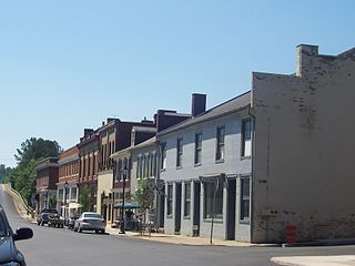
Scottsville is a town in Albemarle, Buckingham and Fluvanna counties in the U.S. state of Virginia. The population was 566 at the 2010 census. It is part of the Charlottesville Metropolitan Statistical Area.

James River River in Virginia, United States

The James River is a river in the U.S. state of Virginia that begins in the Appalachian Mountains and flows 348 miles (560 km) to Chesapeake Bay. The river length extends to 444 miles (715 km) if one includes the Jackson River, the longer of its two source tributaries. It is the longest river in Virginia. Jamestown and Williamsburg, Virginia's first colonial capitals, and Richmond, Virginia's current capital, lie on the James River.

Point of Rocks, Maryland Census-designated place in Maryland, United States

Point of Rocks is an unincorporated community and census-designated place (CDP) in Frederick County, Maryland, United States. As of the 2010 census it had a population of 1,466. It is named for the striking rock formation on the adjacent Catoctin Mountain, which was formed by the Potomac River cutting through the ridge in a water gap, a typical formation in the Appalachian Mountains. The formation is not visible from the town and can only be seen from boats on the river, or from the southern bank of the river in Virginia.

Battle of Rio Hill Battle of the American Civil War

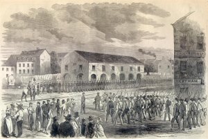
The Battle of Rio Hill was a skirmish in the American Civil War in which Union cavalry raided a Confederate camp in Albemarle County, Virginia.

The Valley campaigns of 1864 began as operations initiated by Union Lieutenant General Ulysses S. Grant and resulting battles that took place in the Shenandoah Valley of Virginia during the American Civil War from May to October 1864. Some military historians divide this period into three separate campaigns. This article considers them together, as these campaigns interacted and built upon each other.

The Battle of Saint Mary's Church was an American Civil War cavalry battle fought on June 24, 1864, as part of Union Lt. Gen. Ulysses S. Grant's Overland Campaign against Confederate Gen. Robert E. Lee's Army of Northern Virginia.

Virginia State Route 6

State Route 6 is a primary state highway in the U.S. state of Virginia. Known for most of its length as River Road, the state highway runs 102.26 miles (164.57 km) from U.S. Route 250 in Afton east to SR 161 in Richmond. SR 6 is one of the main highways of mountainous Nelson County, where the highway runs north–south from its beginning to US 29. From Scottsville to Richmond, the state highway parallels the James River. SR 6 is a major suburban highway through southwestern Henrico County and the main street of Richmond's West End.

Rivanna River River

The Rivanna River is a 42.1-mile-long (67.8 km) tributary of the James River in central Virginia in the United States. The Rivanna's tributaries originate in the Blue Ridge Mountains; via the James River, it is part of the watershed of Chesapeake Bay.

Rockfish River River in the United States

The Rockfish River is a 28.7-mile-long (46.2 km) tributary of the James River in central Virginia in the United States. Via the James River, it is part of the watershed of the Chesapeake Bay.

Westham, Virginia Former Town in Virginia, United States

Westham was an unincorporated town in Henrico County, Virginia. It is located in the present day area of Tuckahoe, Virginia. Westham was built at a transportation point on the James River. The James River flows free for several hundred miles from the west and Westham is located at the point where the Fall Line rocks prevented further river passage. Richmond, Virginia was built on the other side of the fall line where the river is navigable to the ocean. This made Westham the first destination for iron used in Revolutionary War. In later years, Canals and then Rail transport connected Westham to Richmond along the James River trade route. Westham was eventually absorbed into Richmond.

Hatton Ferry is a poled cable ferry located 5.5 miles west of Scottsville, Virginia on the James River. It is the last poled ferry in the United States. The ferry crosses the river upstream of Scottsville between Albemarle County and Buckingham County.

The Battle of Meadow Bridge was an engagement on May 12, 1864, in Henrico County, Virginia, during Lt. Gen. Ulysses S. Grant's Overland Campaign of the American Civil War. Following their victory at the Battle of Yellow Tavern on May 11, Union cavalry under Maj. Gen. Philip H. Sheridan advanced in the direction of the Confederate capital of Richmond. Caught in the narrow area between the fortifications of Richmond and the rain-swollen Chickahominy River, the Union troopers were subjected to fire from the artillery of Confederate Maj. Gen. Fitzhugh Lee. Michigan cavalry under Brig. Gen. George A. Custer forced a crossing of a damaged railroad bridge, which was quickly rebuilt by engineers, allowing the troopers to escape to safety and continue their raid.

First Battle of Deep Bottom Battle of the American Civil War

The First Battle of Deep Bottom, also known as Darbytown, Strawberry Plains, New Market Road, or Gravel Hill, was fought July 27–29, 1864, at Deep Bottom in Henrico County, Virginia, as part of the Siege of Petersburg of the American Civil War. A Union force under Maj. Gens. Winfield S. Hancock and Philip H. Sheridan was sent on an expedition threatening Richmond, Virginia, and its railroads, intending to attract Confederate troops away from the Petersburg defensive line, in anticipation of the upcoming Battle of the Crater. The Union infantry and cavalry force was unable to break through the Confederate fortifications at Bailey's Creek and Fussell's Mill and was withdrawn, but it achieved its desired effect of momentarily reducing Confederate strength at Petersburg.

Winchester, Virginia, in the American Civil War Site of numerous battles during the American Civil War

The city of Winchester, Virginia, and the surrounding area, were the site of numerous battles during the American Civil War, as contending armies strove to control the lower Shenandoah Valley. Winchester changed hands more often than any other Confederate city.

New Canton is an unincorporated town in northeastern Buckingham County, Virginia, United States. It lies along U.S. Route 15 below the James River, northeast of the county seat of Buckingham. It has a post office with the ZIP code 23123.

Wingina, Virginia

Wingina is an unincorporated community in Nelson County, Virginia, United States.

Christ Church Glendower Historic church in Virginia, United States

Christ Church Glendower is the oldest of the historic Episcopal church buildings in St. Anne's Parish, Albemarle County, Virginia near Scottsville. Christ Church Glendower is located in Keene, built of brick in 1831 in the Roman Revival style. It features a full Doric order entablature with pediments at each end containing lunette windows, and is surrounded by a contributing cemetery. The remaining two historic churches in St. Anne's parish are also discussed below.

Scottsville Historic District Historic district in Virginia, United States

Scottsville Historic District is a national historic district located at Scottsville, Albemarle County and Fluvanna County, Virginia. The district encompasses 153 contributing buildings, 1 contributing site, and 4 contributing structures in the town of Scottsville. The district includes commercial, residential, religious, factory and warehouse buildings in a variety of popular architectural styles including Federal, Georgian, Greek Revival, Gothic Revival, Italianate, Queen Anne, Prairie, Colonial Revival, and Craftsman. Notable buildings include Scottsville High School (1920), Riverview (1817), Chester (1847), Belle Haven, Oakwood, Herndon House (1800), The Tavern (mid-1700s), Scottsville Presbyterian Church (1832), Disciples Church (1846), Coleman's Store (1914), and the Fore House (1732). Located in the district and separately listed are Cliffside and Mount Walla.

References

  1. 1 2 "Howardsville". Geographic Names Information System . United States Geological Survey, United States Department of the Interior . Retrieved August 2, 2013.
  2. "National Register Information System". National Register of Historic Places . National Park Service. July 9, 2010.