Fluvanna County is a county located in the Piedmont region of the Commonwealth of Virginia. As of the 2010 census, the population was 25,691. Its county seat is Palmyra.

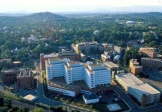
Charlottesville, colloquially known as C'ville, is an independent city in the Commonwealth of Virginia. It is the county seat of Albemarle County, which surrounds the city, though the two are separate legal entities. It is named after the British Queen consort Charlotte of Mecklenburg-Strelitz, who as the wife of George III was Virginia's last Queen. In 2019, an estimated 47,266 people lived within the city limits. The Bureau of Economic Analysis combines the City of Charlottesville with Albemarle County for statistical purposes, bringing its population to approximately 150,000. Charlottesville is the heart of the Charlottesville metropolitan area, which includes Albemarle, Buckingham, Fluvanna, Greene, and Nelson counties.

Albemarle County is a county located in the Piedmont region of the Commonwealth of Virginia. Its county seat is Charlottesville, which is an independent city and enclave entirely surrounded by the county. Albemarle County is part of the Charlottesville Metropolitan Statistical Area. As of the 2010 census, the population was 98,970, in 2018, it was estimated at 108,718.

The Rivanna River is a 42.1-mile-long (67.8 km) tributary of the James River in central Virginia in the United States. The Rivanna's tributaries originate in the Blue Ridge Mountains; via the James River, it is part of the watershed of Chesapeake Bay.

Keswick is an unincorporated community in Albemarle County, Virginia, United States, about six miles east of Charlottesville.

Cobham was a small town in Surry County, Virginia. It was established by an Act of the Virginia House of Burgesses in 1691, when each county in the Virginia Colony was directed set aside 50 acres (200,000 m2) of land for a town. Storehouses were to be built for products imported and tobacco to be exported. It was ordered that the county sell half-acre lots for its citizens to inhabit the town. It was located at the mouth of Gray's Creek at the James River across and somewhat downstream from Jamestown. It was probably named for Cobham, in Surrey, England.

U.S. Route 29 is a major north–south route in the Commonwealth of Virginia. It covers 248 miles (399 km) from the North Carolina border at the city of Danville to the Key Bridge in Washington, D.C.. US 29 roughly bisects Virginia into eastern and western halves, and along with Interstate 81 in western Virginia, and 85/95 farther east, provides one of the major north–south routes through the Commonwealth.

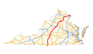
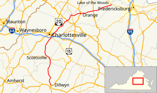
State Route 20 is a primary state highway in the U.S. state of Virginia. The state highway runs 89.79 miles (144.50 km) from U.S. Route 15 in Dillwyn north to SR 3 in Wilderness. SR 20 is a C-shaped route that connects Charlottesville with Farmville in Southside Virginia. The state highway also links Charlottesville to Fredericksburg by way of Orange County, within which SR 20 is the main east–west highway and intersects US 15 again in the county seat of Orange.

U.S. Route 250 is a part of the U.S. Highway System that runs from Sandusky, Ohio to Richmond, Virginia. In Virginia, the highway runs 166.74 miles (268.34 km) from the West Virginia state line near Hightown east to its eastern terminus at US 360 in Richmond. US 250 is the main east–west highway of Highland County, which is known as Virginia's Little Switzerland; the highway follows the path of the 19th century Staunton and Parkersburg Turnpike. From Staunton east to Richmond, the highway serves as the local complement to Interstate 64 (I-64), roughly following the 18th century Three Notch'd Road through Waynesboro and Charlottesville on its way through the Shenandoah Valley, its crossing of the Blue Ridge Mountains at Rockfish Gap, and the Piedmont. In the Richmond metropolitan area, US 250 is known as Broad Street, a major thoroughfare through the city's West End and downtown areas.

Earlysville is an unincorporated community in Albemarle County, Virginia, United States, roughly 9 miles (14 km) north of Charlottesville. It is named for John Early (1773–1833), father of Confederate general Jubal Early. In 1822, John Early bought just under 1,000 acres (4 km2) of land that now comprise a portion of the town. Earlysville has a small central business district, with a grocery store, restaurant, dentist, daycare, mechanic, and several retail stores. As of January 2019 there remains only a thrift store, an auto repair shop, a United States Post Office, and many churches. There is a nearby light industrial park and several small suburban developments. The bulk of the area is rural in character.

Batesville is an unincorporated community in Albemarle County, Virginia, United States. Its elevation is 620 feet (190 m).

Milton is an unincorporated community in Albemarle County, Virginia. In the batteaux era Milton was the head of navigation along the river, but by the mid-nineteenth century horse-drawn canal boats were traveling all the way upstream to Charlottesville, where the head of navigation was located at the very point where the Fredericksburg Road and Three Chopt Road.

Proffit is an unincorporated community in Albemarle County, Virginia. There is no commercial activity, with only houses lining the road and a bridge under which Norfolk Southern's Piedmont Division, Washington District line runs. It is recognized as a Virginia Landmark and the Proffit Historic District was listed on the National Register of Historic Places in 1999.

Rosena is an unincorporated community in Albemarle County, Virginia. It lies at the intersection of Rt. 20 and Rt. 640, within the Stony Point community. The sole service is a single general store, "Grand Junction," which long did business under the name of "Bobbi's." As of 1904, the United States Geological Survey designated it as a "post village," indicating that at that time there was a post office. And as of 1910, the population was great enough to warrant a stop by the "traveling library stations" of the Virginia State Library.

White Hall is an unincorporated community in Albemarle County, Virginia.
Three Notch'd Road was a colonial-era major east-west route across central Virginia. It is believed to have taken its name from a distinctive marking of three notches cut into trees to blaze the trail. By the 1730s, the trail extended from the vicinity of the fall line of the James River at the future site of Richmond westerly to the Shenandoah Valley, crossing the Blue Ridge Mountains at Jarmans Gap. In modern times, a large portion of U.S. Route 250 in Virginia follows the historic path of the Three Notch'd Road, as does nearby Interstate 64.

Troy is an unincorporated community in Fluvanna County, Virginia, United States. It lies just west of U.S. Route 15, between Zion Crossroads to the north and the county seat of Palmyra to the south. Troy's existence was defined by the Virginia Air Line Railway, which operated from 1908 to 1975. In 1998, the Virginia Department of Corrections opened the Fluvanna Correctional Center for Women in the area.

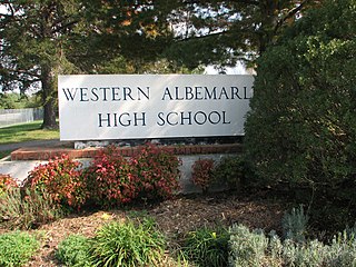
Albemarle County Public Schools (ACPS) is a school district serving Albemarle County, Virginia. Its headquarters are in the City of Charlottesville. ACPS serves approximately 14,000 students in preschool through grade 12 in Albemarle County, Virginia, the sixth largest county by area in the Commonwealth of Virginia. A diverse locality of 726 square miles in the heart of Central Virginia, Albemarle County is a blend of primarily rural, but also suburban and urban settings.

The Charlottesville and Albemarle Railway (C&A) was a short electric street railroad operating within the city of Charlottesville, Virginia, United States, during the early 20th century. The line was preceded by several streetcar lines operating both horse-drawn and electric powered cars dating back to 1887. After facing financial difficulties, the predecessor lines were reorganized into the C&A in 1903. The C&A's electric streetcars operated off of an overhead line system that was powered by the railroad's own power plant. The C&A also offered electric power generated by its plant to the city of Charlottesville. During the mid-1910s, the line received numerous upgrades, including the construction of a new power plant on the Rivanna River, a new company headquarters building, expansion of track, and the purchase of new streetcars.

The Crozet, Virginia train crash was a railway accident that occurred on January 31, 2018. A chartered Amtrak train named Congressional Special Train 923, following the route normally used by the Amtrak Cardinal and carrying a group of politicians and lawmakers from the Republican Party, collided with a garbage truck at a level crossing at Lanetown Road in Crozet, Virginia, 12 miles (19 km) west of Charlottesville, Virginia. The train was chartered by Republican lawmakers for transportation from Washington Union Station to an annual retreat at The Greenbrier in White Sulphur Springs, West Virginia. Several politicians brought their spouses and children with them for the trip; no members of the general public were passengers.


