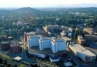
Charlottesville, colloquially known as C'ville, is an independent city in the Commonwealth of Virginia, United States. It is the county seat of Albemarle County, which surrounds the city, though the two are separate legal entities. It is named after Queen Charlotte, wife of George III. At the 2020 census, the population was 46,553. The Bureau of Economic Analysis combines the City of Charlottesville with Albemarle County for statistical purposes, bringing its population to approximately 150,000. Charlottesville is the heart of the Charlottesville metropolitan area, which includes Albemarle, Buckingham, Fluvanna, Greene, and Nelson counties.

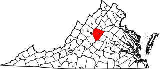
Albemarle County is a county located in the Piedmont region of the Commonwealth of Virginia. Its county seat is Charlottesville, which is an independent city and enclave entirely surrounded by the county. Albemarle County is part of the Charlottesville Metropolitan Statistical Area. As of the 2020 census, the population was 112,395.

Albemarle is a small city and the county seat of Stanly County, North Carolina, United States. The population was 15,903 in the 2010 Census. Gerald R. "Ronnie" Michael serves as Mayor and Albemarle has a seven-member City Council elected in a combination of at-large and district seats. Albemarle has operated under the Council-Manager form of government since 1962. Michael Ferris has served as City Manager since December 2014 and previously served as Assistant City Manager for nearly two decades. The City Manager is appointed by the City Council, and is responsible for the day-to-day administration of City government. The City's Department Heads report directly to the City Manager, who is also responsible for development and administration of the City's annual budget.

Crozet is a census-designated place (CDP) in Albemarle County in the Commonwealth of Virginia, United States. It sits along the I-64 corridor, about 12 miles (19 km) west of Charlottesville and 21 miles (34 km) east of Staunton. Originally called "Wayland's Crossing," it was renamed in 1870 in honor of Colonel Claudius Crozet, the French-born civil engineer who directed the construction of the Blue Ridge Tunnel. The cornerstone of Crozet is believed to have been Pleasant Green, a property also known as the Ficklin-Wayland Farm, located yards from the actual Wayland Crossing. Claudius Crozet is said to have lodged in that property while surveying the land that today honors his name. The population of Crozet was 5,565 at the 2010 census. Crozet is part of the Charlottesville Metropolitan Statistical Area.
Keene is an unincorporated community in Albemarle County, Virginia, United States. As of the 1990 census, the town had a total population of 10.

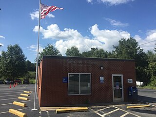
Shadwell is a census-designated place (CDP) in Albemarle County, Virginia. It is located by the Rivanna River near Charlottesville. The site today is marked by a Virginia Historical Marker to mark the birthplace of President Thomas Jefferson. It is listed on the National Register of Historic Places along with Clifton.

Waterford is an unincorporated village and census-designated place (CDP) in the Catoctin Valley of Loudoun County, Virginia, located along Catoctin Creek. Waterford is 47 miles (76 km) northwest of Washington, D.C., and 7 miles (11 km) northwest of Leesburg. The entire village and surrounding countryside is a National Historic Landmark District, noted for its well-preserved 18th and 19th-century character.

Buildings, sites, districts, and objects in Virginia listed on the National Register of Historic Places:

Keswick is a Census-designated place in Albemarle County, Virginia, United States, about six miles east of Charlottesville.

The Marine Mill, established in 1839, was the first commercial sawmill in what became the U.S. state of Minnesota. Now in ruins, it is currently a historic site managed by the city of Marine on St. Croix in partnership with the Minnesota Historical Society. It was listed on the National Register of Historic Places as the Marine Mill Site in 1970 for having state-level significance in the themes of exploration/settlement, industry, and transportation. It was nominated for being the birthplace of the region's seminal industry—lumbering—and a major landing on its crucial transportation route, the St. Croix River. The site is also a contributing property to the Marine on St. Croix Historic District.
Midway Mills is an unincorporated community in Nelson County, Virginia, United States. Originally called Midway, the settlement was established on June 6, 1774, by Dr. William Cabell,, and was the first European settlement in Nelson County. It was named Midway because it was midway between Richmond and Lynchburg along the James River. The area, at that time part of "Old Albemarle County", was later divided into the counties of Albemarle, Amherst, Buckingham, Nelson, and Fluvanna between 1741 and 1809.
Cismont is an unincorporated community in Albemarle County, Virginia.

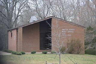
Covesville is an unincorporated community in Albemarle County, Virginia, United States. Covesville is located 15.7 miles (25.3 km) southwest of Charlottesville, Virginia and has a post office with ZIP code 22931.
Esmont is a census-designated place (CDP) in Albemarle County, Virginia, United States. The population as of the 2020 Census was 491.

Greenwood is an unincorporated community in Albemarle County, Virginia, United States. It is home to the Greenwood Country Store and the Greenwood Community Center, which has the area's only roller skating rink. Greenwood has a post office with ZIP code 22943 The Greenwood Tunnel, built by Claudius Crozet for the Blue Ridge Railroad and used by the Chesapeake and Ohio Railway until its abandonment during World War II, is near Greenwood by the Buckingham Branch Railroad tracks.
Proffit is an unincorporated community in Albemarle County, Virginia. There is no commercial activity, with only houses lining the road and a bridge under which Norfolk Southern's Piedmont Division, Washington District line runs. It is recognized as a Virginia Landmark and the Proffit Historic District was listed on the National Register of Historic Places in 1999.
This is a list of the National Register of Historic Places listings in Albemarle County, Virginia.
North Garden is a Census-designated place in Albemarle County, Virginia, United States. The population as of the 2020 United States census was 461.

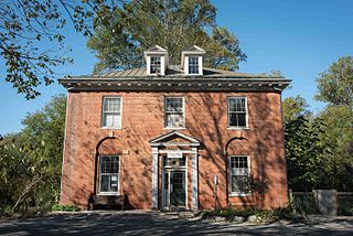
Charlottesville and Albemarle County Courthouse Historic District, also known as the Charlottesville Historic District is a national historic district located at Charlottesville, Virginia. The district encompasses the previously listed Albemarle County Courthouse Historic District and includes 269 contributing buildings and 1 contributing object in the city of Charlottesville. It includes the traditional heart of the city's commercial, civic, and religious activities, with early residential development and industrial sites located along the fringe. The commercial core is located along a seven block Downtown Mall designed by Lawrence Halprin (1916-2009). Notable buildings include the Albemarle County Courthouse, Levy Opera House, Number Nothing, Redland Club, Eagle Tavern, United States Post Office and Courts Building (1906), Christ (Episcopal) Church (1895-1898), Beth Israel Synagogue (1882-1903), Holy Comforter Catholic Church (1925), First Methodist Church (1924), McIntire Public Library (1919-1922), and Virginia National Bank (1916). Also located in the district are the separately listed Abell-Gleason House, William H. McGuffey Primary School, Thomas Jonathan Jackson sculpture, Robert Edward Lee sculpture, and Marshall-Rucker-Smith House.

The Missouri Lumber and Mining Company (MLM) was a large timber corporation with headquarters and primary operations in southeast Missouri. The company was formed by Pennsylvania lumbermen who were eager to exploit the untapped timber resources of the Missouri Ozarks to supply lumber, primarily used in construction, to meet the demand of U.S. westward expansion. Its primary operations were centered in Grandin, a company town it built starting c. 1888. The lumber mill there grew to be the largest in the country at the turn of the century and Grandin's population peaked around 2,500 to 3,000. As the timber resources were exhausted, the company had to abandon Grandin around 1910. It continued timber harvesting in other parts of Missouri for another decade. While some of the buildings in Grandin were relocated, many of the remaining buildings were listed on the National Register of Historic Places in 1980 as part of the state's historic preservation plan which considered the MLM a significant technological and economic contributor to Missouri.


