Hyrax Hill

Last updated
Hyrax Hill
Kenya relief location map.jpg
Red pog.svg
Hyrax Hill Site
LocationKenya
Coordinates 0°16′56″N36°6′14″E / 0.28222°N 36.10389°E / 0.28222; 36.10389

Hyrax Hill is a prehistoric site near Nakuru in the Rift Valley province of Kenya. It is a rocky spur roughly half a kilometer in length, with an elevation of 1,900 meters above sea level at its summit. [1] The site was first discovered in 1926 by Louis Leakey during excavations at the nearby Nakuru Burial Site, and Mary Leakey conducted the first major excavations between 1937 and 1938. [2] There are two distinct areas of occupation at Hyrax Hill: one which was occupied during the Pastoral Neolithic and late Iron Age, and one which was occupied by the Sirikwa earlier in the Iron Age.

Contents

Hyrax Hill is named after the hyrax, a small mammal that lives in rocky areas. Hyraxes were once common in the rocky crevasses of Hyrax Hill, but their numbers have dropped in recent years due to the rapid urbanization of the surrounding area. [3]

Hyrax Hill is the location of Hyrax Hill Prehistoric Site and Museum.

History of excavation

Mary and Louis Leakey excavating at Olduvai Gorge, Tanzania Mary Douglas Nicol Leakey (1913-1996) and her husband Louis Seymour Bazett Leakey (1903-1972).jpg
Mary and Louis Leakey excavating at Olduvai Gorge, Tanzania

Louis Leakey discovered the remains of prehistoric settlements at Hyrax Hill while excavating the nearby Nakuru Burial in 1926. He did not excavate it at the time because he believed it to be a recent occupation, and was busy working at several other sites. Louis Leakey returned to the area in 1937 with his wife, Mary Leakey. It was Mary Leakey who began major excavations at Hyrax Hill. She excavated and named both Site I and Site II between 1937 and 1938. With no carbon dating technology available, dating the sites was difficult at the time. Leakey mistakenly described the Iron Age "Sirikwa Holes" as a pre-Iron Age village with "pit-dwellings." Excavations at the site were not undertaken again until after Hyrax Hill was obtained by the National Museums of Kenya in 1965, at which time one of the Sirikwa holes was fully excavated by Ron Clark and museum staff for display at the museum. [4]

Location and environment

Hyrax Hill is located near Lake Nakuru. 5000 to 6000 years ago, during the occupation of Site I, a wetter climate meant that lake levels were as much as 100 meters higher than their present levels. Hyrax Hill was a peninsula at this time, which jutted out into the north side of the lake. The occupants would have had access to a steady supply of fresh water, as well as fish. [5] Mary Leakey identified the ancient rocky beach of the lake in her 1938 excavations. The early occupation of Site I lies directly on the ancient beach, and she was able to use this and relative dating to date this portion of the site. [6]

Lake levels began to drop starting 3500 years ago, and the area became a more open savanna grassland. The drier environment was well suited to the pastoralism used by the later Sirikwan inhabitants of Site II. [7]

Archaeology

Site I

"Site I" is the area of Hyrax Hill that was occupied during the Neolithic and late Iron Age. Although the early occupation of the site 5000 years ago is frequently referred to as the "Neolithic" (a trend started by Louis and Mary Leakey during the first excavations in the area), evidence has yet to be found for the cultivation of crops or raising of animals at the early occupation of Site I at Hyrax Hill. [8] The Iron Age portion of the site dates to around 200 years ago, and consists of several stone enclosures and a large midden. Directly under this layer was an earlier Neolithic cemetery. [9] The Neolithic cemetery consisted of several low burial mounds formed out of large blocks of stone. Many of the individuals buried at the site were dismembered. [10]

The occupants of this period of the site manufactured distinctive ground stone bowls, and many were found associated with female burials in the Neolithic cemetery at Hyrax Hill and other sites in the area. [11] The bowls from Hyrax Hill are round or oblong, particularly shallow, and made from an easily accessed local variety of stone. [12] Because these bowls were so distinctive at many sites in the Rift Valley, archaeologists created the term "Stone Bowl Culture" to encompass the Neolithic culture they were believed to represent. The term "Stone Bowl Culture" is not widely used today, having been supplanted by "Savanna Pastoral Neolithic", a culture which Christopher Ehret indicates was likely produced by early Cushitic settlers. [13] In Kenya, the broader term "Pastoral Neolithic" refers to sites archaeological containing a Later Stone Age lithic industry, predominant livestock husbandry, and ceramic vessels. [14]

The ceramic type known as "Nderit ware" is found at Site I. These are rounded vessels with a highly textured surface of wedge-shaped impressions, which are commonly found at Neolithic sites in eastern Africa. They resemble baskets. [15]

Site II

"Site II" lies on the north-western side of Hyrax hill, opposite from Site I. It was occupied earlier in the Iron Age than Site I. Radiocarbon dates have found that Site II was occupied between the twelfth and fifteenth centuries AD. [16] Site II was occupied by the Sirikwa, a later group of cattle pastoralists. The main feature of this site is a series of thirteen sandy bowl-shaped depressions and mounds. These depressions, called Sirikwa Holes, were deliberately constructed as pens for securing cattle, and the low mounds that are adjacent to these hollows were created from heaping dung and refuse outside the pen. [16] The remains of cattle, goats, and sheep have been found at Site II, many of which show cut-marks and signs of human use. John Sutton's excavations in 1985 found the mandible of an equine species, possibly a donkey. [17] Excavations in 1990 identified the cattle as likely belonging to the Zebu species. Further analysis showed that female cows were only slaughtered until after lactating age, indicating an emphasis on milk production. This excavation also found the remains of a domesticated dog, the first ever found at a Sirikwa site. Scavenging domesticated dogs possibly account for the carnivore gnaw-marks that have been found on bones at the site. [18]

Zebu cattle similar to those that would have been raised by the Sirikwa. Vuurtoren Evatra IV.jpg
Zebu cattle similar to those that would have been raised by the Sirikwa.

Site II was mistakenly identified as a late Neolithic site when it was first excavated, and Mary Leakey assigned it to the Neolithic "Gumban B" culture which Louis Leakey had identified from earlier excavations in the area. Few Iron-Age sites had been excavated in the area, and there was no reliable way for Mary Leakey to date the site. Few iron artifacts have ever been found at Site II, which further confused the actual date. Scattered obsidian flakes similar to those used by earlier cultures were also found at the site. It is unknown whether these were made by the inhabitants of Site II, or the earlier inhabitants of Site I. [19]

The pottery found at Site II is "Lanet ware" dated to the Iron Age. [20] It consists of tall beakers with simple rims, rounded bottoms, and decoration made from cord impressions. These occasionally have small spouts and rounded handles. The pottery has a distinctive "sand paper" finish, and some vessels have been found with red slips. [21]

Other archaeological areas

Archaeological remains have been found on the hill outside of Sites I and II. At the top of the hill is a cleared area, possibly created by the later inhabitants of Site I or the inhabitants of Site II. [22] Mary Leakey described it as possibly being a stone circle or fort. [23]

Two bao boards are carved into rock outcroppings at the north side of the hill. One is only partially preserved, but both appear to be a two-row version of the game rather than a four-row version. They are thought to be associated with the Site II Sirikwa habitation. [22]

Gumban nomenclature

While investigating archaeological sites in Kenya, Louis Leakey identified early sites belonging to the Neolithic period. He named these "Gumban" sites, after small forest-dwellers in Kikuyu mythology that were said to have lived in the area before the Kikuyu. He further broke the category down into the "Gumban A" and "Gumban B" variations. [24] Leakey did not intend to imply that the Gumba were the creators of the Neolithic sites, but intended the term to broadly refer to a culture that predated the modern inhabitants of the area. [25] Leakey used this term while excavating the nearby Nakuru burial site, and Mary Leakey continued the usage when excavating Hyrax Hill. The name has since fallen out of use, due to its misleading nature. [26] "Gumban B" was originally identified as a Neolithic culture, but it was often mistakenly used to refer to sites that are now correctly dated to the Iron-Age. There was no reliable way to date the sites at the time, and Louis Leakey accidentally included Iron-Age pottery sherds among the "Gumban B" artifacts of the pre-Iron-Age Nakuru Burial site. Thus, Iron-Age sites like Site II of Hyrax hill became associated with Neolithic "Gumban B" sites until a clearer chronology of the area was developed. [19]

The pottery types found at Hyrax Hill were originally named "Gumban A" and "Gumban B" by Louis and Mary Leakey when they were first discovered at Hyrax Hill and the Nakuru Burial Site. These terms fell out of use along with the term "Gumban". The ceramic type formerly known as "Gumban A" is now known as "Nderit ware" and the type formerly known as "Gumban B" is now known as "Lanet ware." Both these names refer to the locations that the ceramic types were first identified. [15] [27]

See also

Notes

  1. Sutton, J. E. G. (1987). "Hyrax Hill and the Sirikwa". Azania. 22 (1): 1–36. doi:10.1080/00672708709511378.
  2. Leakey, Mary (1943). "Report on the excavations at Hyrax Hill, Nakuru, Kenya Colony, 1937–1938". Transactions of the Royal Society of South Africa. 30 (4): 274. doi:10.1080/00359194309519847.
  3. Sutton, John (1998). "Hyrax Hill and the Later Archaeology of the Central Rift Valley of Kenya". Azania. 33: 74. doi:10.1080/00672709809511465.
  4. Sutton, John (1998). "Hyrax Hill and the Later Archaeology of the Central Rift Valley of Kenya". Azania. 33: 99–102. doi:10.1080/00672709809511465.
  5. Sutton, John (1998). "Hyrax Hill and the Later Archaeology of the Central Rift Valley of Kenya". Azania. 33: 76–78. doi:10.1080/00672709809511465.
  6. Leakey, Mary (1943). "Report on the excavations at Hyrax Hill, Nakuru, Kenya Colony, 1937–1938". Transactions of the Royal Society of South Africa. 30 (4): 274–279. doi:10.1080/00359194309519847.
  7. Sutton, John (1998). "Hyrax Hill and the Later Archaeology of the Central Rift Valley of Kenya". Azania. 33: 78–79. doi:10.1080/00672709809511465.
  8. Sutton, John (1998). "Hyrax Hill and the Later Archaeology of the Central Rift Valley of Kenya". Azania. 33: 77–84. doi:10.1080/00672709809511465.
  9. Sutton, John (1998). "Hyrax Hill and the Later Archaeology of the Central Rift Valley of Kenya". Azania. 33: 86–98. doi:10.1080/00672709809511465.
  10. Leakey, Mary (1943). "Report on the excavations at Hyrax Hill, Nakuru, Kenya Colony, 1937–1938". Transactions of the Royal Society of South Africa. 30 (4): 314–316. doi:10.1080/00359194309519847.
  11. Bower, John (March 1991). "The Pastoral Neolithic of Eastern Africa". Journal of World Prehistory. 5 (1): 51. doi:10.1007/bf00974732. S2CID   162352311.
  12. Leakey, Mary (1943). "Report on the excavations at Hyrax Hill, Nakuru, Kenya Colony, 1937–1938". Transactions of the Royal Society of South Africa. 30 (4): 326–332. doi:10.1080/00359194309519847.
  13. Christopher Ehret, Merrick Posnansky (ed.) (1982). The Archaeological and Linguistic Reconstruction of African History. University of California Press. p. 140. ISBN   0520045939 . Retrieved 4 December 2014.{{cite book}}: |last1= has generic name (help)
  14. Roger Blench, Kevin MacDonald (ed.) (2006). Origins and Development of African Livestock: Archaeology, Genetics, Linguistics and Ethnography. Routledge. p. 200. ISBN   1135434166 . Retrieved 24 December 2014.{{cite book}}: |last1= has generic name (help)
  15. 1 2 Sutton, John (1964). "A Review of Pottery from the Kenya Highlands". The South African Archaeological Bulletin. 19 (74): 27–35. doi:10.2307/3888232. JSTOR   3888232.
  16. 1 2 Kyule, David (1997). "The Sirikwa Economy". Azania. 32 (1): 21–30. doi:10.1080/00672709709511586.
  17. Sutton, J. E. G. (1987). "Hyrax Hill and the Sirikwa". Azania. 22 (1): 29. doi:10.1080/00672708709511378.
  18. Kyule, David (1997). "The Sirikwa Economy". Azania. 32 (1): 27–29. doi:10.1080/00672709709511586.
  19. 1 2 Sutton, J. E. G. (1987). "Hyrax Hill and the Sirikwa". Azania. 22 (1): 3. doi:10.1080/00672708709511378.
  20. Posnansky, Merrick (1961). "Pottery Types from Archaeological Sites in East Africa". The Journal of African History. 2 (2): 183. doi:10.1017/s0021853700002401. JSTOR   179995. S2CID   161223539.
  21. Leakey, Mary (1943). "Report on the excavations at Hyrax Hill, Nakuru, Kenya Colony, 1937–1938". Transactions of the Royal Society of South Africa. 30 (4): 304–306. doi:10.1080/00359194309519847.
  22. 1 2 Sutton, J. E. G. (1987). "Hyrax Hill and the Sirikwa". Azania. 22 (1): 36. doi:10.1080/00672708709511378.
  23. Leakey, Mary (1943). "Report on the excavations at Hyrax Hill, Nakuru, Kenya Colony, 1937–1938". Transactions of the Royal Society of South Africa. 30 (4): 1. doi:10.1080/00359194309519847.
  24. Sutton, J. E. G. (2007). "Archeology and Reconstructing History in the Kenya Highlands: The Intellectual Legacies of G.W.B. Huntingford and Louis S.B. Leakey". History in Africa. 34: 312. doi:10.1353/hia.2007.0021. JSTOR   25483701. S2CID   162626035.
  25. Leakey, Louis (1931). Stone age cultures of kenya colony. Cambridge: Cambridge Univ. Press. p. 243. ISBN   978-1-107-61547-2.
  26. Sutton, John (1998). "Hyrax Hill and the Later Archaeology of the Central Rift Valley of Kenya". Azania. 33: 77. doi:10.1080/00672709809511465.
  27. Robertshaw, Peter; Collett, David (1983). "A New Framework for the Study of Early Pastoral Communities in East Africa". The Journal of African History. 24 (3): 299. doi:10.1017/s0021853700022027. JSTOR   181896. S2CID   162241034.

Related Research Articles

<span class="mw-page-title-main">Mary Leakey</span> British paleoanthropologist (1913–1996)

Mary Douglas Leakey, FBA was a British paleoanthropologist who discovered the first fossilised Proconsul skull, an extinct ape which is now believed to be ancestral to humans. She also discovered the robust Zinjanthropus skull at Olduvai Gorge in Tanzania, eastern Africa. For much of her career she worked with her husband, Louis Leakey, at Olduvai Gorge, where they uncovered fossils of ancient hominines and the earliest hominins, as well as the stone tools produced by the latter group. Mary Leakey developed a system for classifying the stone tools found at Olduvai. She discovered the Laetoli footprints, and at the Laetoli site she discovered hominin fossils that were more than 3.75 million years old.

<span class="mw-page-title-main">Nakuru County</span> County in Kenya

Nakuru County is a county in Kenya. It is county number 32 out of the 47 Kenyan counties. Nakuru County is a host to Kenya's Fourth City – Nakuru City. On 1 December 2021, President Uhuru Kenyatta awarded a City Charter status to Nakuru, ranking it with Nairobi, Mombasa, and Kisumu as the cities in Kenya. With a population of 2,162,202, it is the third most populous county in Kenya after Nairobi County and Kiambu County, in that order. With an area of 7,496.5 km2, it is Kenya's 19th largest county in size. Until 21 August 2010, it formed part of Rift Valley Province.

<span class="mw-page-title-main">Engaruka</span> National Historic Site of Tanzania

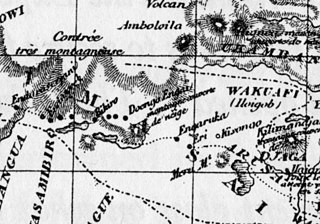
Engaruka is an abandoned system of ruins located in northwest Monduli District in central Arusha Region. The site is in geographical range of the Great Rift Valley of northern Tanzania. Situated in the Monduli District, it is famed for its irrigation and cultivation structures. It is considered one of the most important Iron Age archaeological sites in Tanzania. The site is located in the ward of Engaruka. The site is registered as one of the National Historic Sites of Tanzania.

<span class="mw-page-title-main">Kondoa Rock-Art Sites</span> National Historic Site of Tanzania

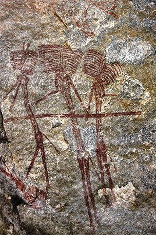
The Kondoa Rock-Art Sites or Kondoa Irangi Rock Paintings are a series of ancient paintings on rockshelter walls in central Tanzania. The Kondoa region was declared a UNESCO World Heritage Site in 2006 because of its impressive collection of rock art. These sites were named national monuments in 1937 by the Tanzania Antiquities Department. The paintings are located approximately nine kilometres east of the main highway (T5) from Dodoma to Babati, about 20 km north of Kondoa town, in Kondoa District of Dodoma Region, Tanzania. The boundaries of the site are marked by concrete posts. The site is a registered National Historic Sites of Tanzania.

<span class="mw-page-title-main">Urewe</span>

The Urewe culture developed and spread in and around the Lake Victoria region of Africa during the African Iron Age. The culture's earliest dated artefacts are located in the Kagera Region of Tanzania, and it extended as far west as the Kivu region of the Democratic Republic of the Congo, as far east as the Nyanza and Western provinces of Kenya, and north into Uganda, Rwanda and Burundi. Sites from the Urewe culture date from the Early Iron Age, from the 5th century BC to the 6th century AD. The Urewe people certainly did not disappear, and the continuity of institutional life was never completely broken. One of the most striking things about the Early Iron Age pots and smelting furnaces is that some of them were discovered at sites that the local people still associate with royalty, and still more significant is the continuity of language.

<span class="mw-page-title-main">Tana ware</span>

Tana ware refers to a type of prehistoric pottery prominent in East Africa that features a variety of designs, including triangular incised lines and single rows of dots. The presence of this pottery is largely regarded as one of the best indicators for early Swahili settlement. This pottery tradition falls chronologically during the Iron Age in East Africa, during the late first millennium AD and spanning several hundred years. The name Tana ware was given because the early discoveries of these types of pottery were along the Tana River in present day Kenya.

<span class="mw-page-title-main">Hyrax Hill Prehistoric Site and Museum</span> History museum near Nakuru, Kenya

The Hyrax Hill site was proclaimed a national monument in 1945 and opened to the public in 1965. This was as a result of startling discoveries of relics by Mrs. Selfe and subsequent archaeological excavations that were carried out by Dr. Mary Leakey in 1938 that revealed substantial findings in different areas of the site and levels of occupations. The late Mrs. Selfe was the owner of the property. The renovation of archaeology exhibit was made possible through the kind sponsorship of Kenya Museum Society and consultation of British Institute in Eastern Africa in collaboration with the National Museums of Kenya. The hill comprises particular importance due to the fact that it encompasses several phases of occupation; it also has a long history of archaeological investigation, which began in 1937 with Mary Leakey.

Ngenyn is a Late Stone Age and/or a Savanna Pastoral Neolithic archaeological site located in the Kapthurin River Basin, which is part of the Tugen Hills, west of Lake Baringo. It falls within the Baringo County in north central Kenya. The occupied area is situated on the floodplain of the River Ndau's confluence with the Sekutionnen River, on a widespread terrace called the Low Terrace, the top of which is about 3m above the level of the modern river. The site was initially discovered by Louis Leakey in 1969. It was visible as a large exposure of bones, stone tools and pottery eroding out of the terrace. The site was excavated in the late 1970s as part of Francoise Hivernel's PhD research. Ngenyn remains the only Late Holocene site excavated in the Lake Baringo Basin and in general very little archaeological work has been done on the Late Holocene within the Baringo County.

Nakuru District was a district in the Rift Valley Province, Kenya. The district capital was Nakuru. With a population of 1,187,039, following the Nairobi region. Nakuru District had an area of 7,242 km².

<span class="mw-page-title-main">Savanna Pastoral Neolithic</span> Archaeological cultures of the Rift Valley of East Africa

The Savanna Pastoral Neolithic is a collection of ancient societies that appeared in the Rift Valley of East Africa and surrounding areas during a time period known as the Pastoral Neolithic. They were South Cushitic speaking pastoralists who tended to bury their dead in cairns, whilst their toolkit was characterized by stone bowls, pestles, grindstones and earthenware pots.

<span class="mw-page-title-main">Pastoral Neolithic</span> Historic site in Tanzania

The Pastoral Neolithic refers to a period in Africa's prehistory, specifically Tanzania and Kenya, marking the beginning of food production, livestock domestication, and pottery use in the region following the Later Stone Age. The exact dates of this time period remain inexact, but early Pastoral Neolithic sites support the beginning of herding by 5000 BP. In contrast to the Neolithic in other parts of the world, which saw the development of farming societies, the first form of African food production was nomadic pastoralism, or ways of life centered on the herding and management of livestock. The shift from hunting to food production relied on livestock that had been domesticated outside of East Africa, especially North Africa. This period marks the emergence of the forms of pastoralism that are still present. The reliance on livestock herding marks the deviation from hunting-gathering but precedes major agricultural development. The exact movement tendencies of Neolithic pastoralists are not completely understood.

Ngamuriak is an archaeological site located in south-western Kenya. It has been interpreted as an Elmenteitan Pastoral Neolithic settlement. The excavation of this site produced pottery sherds, stone tools with obsidian fragments and obsidian blades, along with large amounts of animal bones.

Gogo Falls is an archaeological site near a former and since 1956 dammed waterfall, located in the Lake Victoria Basin in Migori County, western Kenya. This site is important to archaeology as it includes some of the earliest appearances of artifacts and domestic animals in the area. The findings at the site help to reconstruct the later prehistory around Lake Victoria, including a Pastoral Neolithic occupation by Elmenteitan peoples and a later Iron Age occupation. Artifacts found at the site included pottery and iron artifacts. Through these artifacts some of the cultural traditions of the people who lived near Gogo Falls were discovered.

Njoro River Cave is an archaeological site on the Mau Escarpment, Kenya, that was first excavated in 1938 by Mary Leakey and her husband Louis Leakey. Excavations revealed a mass cremation site created by Elmenteitan pastoralists during the Pastoral Neolithic roughly 3350-3050 BP. Excavations also uncovered pottery, beads, stone bowls, basket work, pestles and flakes. The Leakeys' excavation was one of the earliest to uncover ancient beads and tools in the area and a later investigation in 1950 was the first to use radiocarbon dating in East Africa.

<span class="mw-page-title-main">Elmenteitan</span> African Pastoral Neolithic culture

The Elmenteitan culture was a prehistoric lithic industry and pottery tradition with a distinct pattern of land use, hunting and pastoralism that appeared and developed on the western plains of Kenya, East Africa during the Pastoral Neolithic c.3300-1200 BP. It was named by archaeologist Louis Leakey after Lake Elmenteita, a soda lake located in the Great Rift Valley, about 120 km (75 mi) northwest of Nairobi.

Sirikwa holes are saucer-shaped hollows found on hillsides in the western highlands of Kenya and in the elevated stretch of the central Rift Valley around Nakuru. These hollows, each having a diameter of 10–20 metres and an average depth of 2.4 metres, occur in groups, sometimes numbering fewer than ten and at times more than a hundred. Archaeologists believe that construction of these features may have begun in the Iron Age.

<span class="mw-page-title-main">Sirikwa culture</span> Pastoral Iron Age Kenyan culture

The Sirikwa culture was the predominant Kenyan hinterland culture of the Pastoral Iron Age, c.2000 BP. Seen to have developed out of the Elmenteitan culture of the East African Pastoral Neolithic c.3300-1200 BP, it was followed in much of its area by the Kalenjin, Maa, western and central Kenyan communities of the 18th and 19th centuries.

Nasera Rockshelter is an archaeological site located in the Ngorongoro Conservation Area within Ngorongoro District of Arusha Region in northern Tanzania, and it has evidence of Middle Stone Age and Later Stone Age occupations in the Late Pleistocene to early Holocene, and ceramic-bearing Holocene occupations attributed to Kansyore, Nderit, and Savanna Pastoral Neolithic traditions. It was first excavated by Louis Leakey in 1932. A second series of excavations by Michael Mehlman in 1975 and 1976 led to the first comprehensive published study of the shelter, its stratigraphy and chronology, and its abundant material culture, including stone tools, faunal remains, and pottery. Recent work has sought to better understand chronology, lithic technology, mobility and demography, and site formation processes at Nasera Rockshelter. Nasera Rockshelter is considered a key site in eastern Africa for understanding the Middle Stone Age to Later Stone Age transition, and also for the study of the spread of livestock herding during the Pastoral Neolithic. Its chronology and archaeological sequence have been compared to those of other key sites in the region such as Mumba Rockshelter, Kisese II Rockshelter, Panga ya Saidi, and Enkapune ya Muto.

<span class="mw-page-title-main">Nderit pottery</span> Ceramics from some African archaeological sites

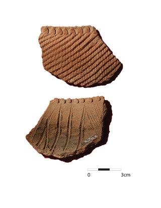
Nderit pottery is a type of ceramic vessel found at archaeological sites in Africa, particularly Tanzania and Kenya. Nderit pottery, previously known as ceramic tradition "Gumban A ware," was initially documented by Louis Leakey in the 1930s at sites in the Central Rift Valley of Kenya.Stylistic characteristics of Nderit pottery discovered in the Central Rift Valley include an exterior decoration of basket-like and triangular markings into the clay’s surface. The vessels here also have intensely scored interiors that do not appear to follow a distinct pattern. Nderit Ware exemplifies the transition from Saharan wavy-line early Holocene pottery towards the basket-like designs of the middle Holocene. Lipid residue found on Nderit pottery can be used to analyze the food products stored in them by early pastoralist societies.

Prospect Farm is an archaeological site on the northern side of Mt. Eburru that has been known to show evidence of prehistoric inhabitants. Excavations have uncovered tool-based artifacts that date to the Middle Stone Age, Later Stone Age, and Pastoral Neolithic that were recognized to be a unique Prospect Industry style. Additionally, bowls were found of the Savanna Pastoral Neolithic. With the large amounts of artifacts found, current work lies in using forms of dating like radiocarbon dating and obsidian hydration to understand the specifics of when these artifacts originated, as well as when the land was used. Current research seeks to build upon this by trying to understand how inhabitants of the Prospect Farm interacted with other groups.

References