List of road junctions in the United Kingdom: G

Last updated

Thickthorn Interchange Thickthorn Interchange - geograph.org.uk - 73633.jpg
Thickthorn Interchange

This is part of the list of road junctions in the United Kingdom.

Many road junctions are named after pubs. For more information regarding the derivation of pub names see pub names.

G

Junction NameTypeLocationRoadsGrid ReferenceNotes
Gabalfa Interchange
  • aka The Flyover
Cardiff, Wales
  • A48 Western Avenue
  • A48 Eastern Avenue
  • A470 North Road
  • A469 Whitchurch Road
ST169791
Gailey Interchange
  • aka Gailey Motorway Island
Cannock, Staffordshire 52°41′23″N2°06′11″W / 52.68972°N 2.10306°W / 52.68972; -2.10306
Gailey Island Cannock, Staffordshire 52°41′35″N2°07′52″W / 52.69306°N 2.13111°W / 52.69306; -2.13111
Galley Hill RoundaboutStony Stratford, Milton Keynes 52°03′02″N0°50′24″W / 52.05056°N 0.84000°W / 52.05056; -0.84000
Galleys Roundabout (formerly Galley's Corner) Braintree, Essex
  • A120
  • B1018
  • Long Green
TL778220
Gallions Round Beckton, LB Newham
  • A117 Woolwich Manor Way
  • A1020 Royal Albert Way
  • A1020 Royal Docks Way
  • Armada Way
  • Gallions Road
  • University Way
51°30′29″N0°04′13″E / 51.50806°N 0.07028°E / 51.50806; 0.07028
Gallows Corner [1] Roundabout with flyover Romford, LB Havering
  • A12 Eastern Avenue
  • A12 Colchester Road
  • A118 Main Road (formerly A12)
  • A127 Southend Arterial Road
  • Straight Road
51°35′34″N0°12′45″E / 51.59278°N 0.21250°E / 51.59278; 0.21250
Gants Hill Cross [2] Roundabout Gants Hill, LB Redbridge 51°34′35″N0°03′59″E / 51.57639°N 0.06639°E / 51.57639; 0.06639
Ganwick CornerCrossroads Potters Bar, Hertfordshire
  • A1000 Great North Road (formerly A1)
  • Dancers Hill Road
51°40′55″N0°11′13″W / 51.68194°N 0.18694°W / 51.68194; -0.18694
Gartcosh Glasgow 55°53′36″N4°04′16″W / 55.89333°N 4.07111°W / 55.89333; -4.07111
Gates' Corner (former location of)Crossroads South Woodford, LB Redbridge
  • A406 Southend Road
  • A1199 High Rd. Woodford Green (formerly A11)
51°35′45″N0°01′18″E / 51.59583°N 0.02167°E / 51.59583; 0.02167 The North Circular now passes under the junction, with no vehicle access to the Woodford Green High Road. But pedestrian access has been maintained.
The GeorgeCrossroads South Woodford, LB Redbridge
  • A1199 High Road (formerly A11)
  • B168 George Lane
TQ402904 Named after the pub on the junction. The shops at the top of George Lane are also known as the Electric Parade
George Junction Plymouth
  • A386 Tavistock Road
  • B3432 Plymbridge Road
  • Southway Drive
50°25′38″N4°06′47″W / 50.4271°N 4.1130°W / 50.4271; -4.1130
Germoe Cross RoadsGermoe, Cornwall
  • A394
  • Pengersick Lane
SW582291
Giffard Park RoundaboutBlakelands, Milton Keynes 52°04′45″N0°44′54″W / 52.07917°N 0.74833°W / 52.07917; -0.74833
Gillette Corner Brentford, LB Hounslow
  • A4 Great West Road
  • B454 Syon Lane
51°29′00″N0°19′37″W / 51.48333°N 0.32694°W / 51.48333; -0.32694
Gildersome Interchange Morley, West Yorkshire 53°44′48″N1°37′51″W / 53.74667°N 1.63083°W / 53.74667; -1.63083
Gipsy Lane Roundabout Luton, Bedfordshire 51°52′10″N0°23′50″W / 51.86944°N 0.39722°W / 51.86944; -0.39722
Girton InterchangeModified Cloverleaf Girton, Cambridgeshire 52°13′50″N0°04′14″E / 52.23056°N 0.07056°E / 52.23056; 0.07056
Givons Grove Roundabout Leatherhead, Surrey
  • A24 Dorking Road
  • A24 By-Pass Road
  • A246 Young Street
  • B2450 Dorking Road
TQ167550
The Glanty Egham, Surrey
  • A30 Egham By-pass
  • A308 The Glanty
  • B388
TQ017718
Glasgow Airport Glasgow
  • M8 J28
  • unclass.
55°51′43″N4°25′58″W / 55.86194°N 4.43278°W / 55.86194; -4.43278 webcam
Gleadless Townend Gleadless, South Yorkshire 53°20′43″N1°25′32″W / 53.34528°N 1.42556°W / 53.34528; -1.42556
Godstone Interchange Godstone, Surrey
  • M25 J6
  • A22 Godstone By-pass
  • A22 Godstone Hill
  • B2235 Godstone Hill
51°15′34″N0°03′54″W / 51.25944°N 0.06500°W / 51.25944; -0.06500
Gogar Junction Gogar, Edinburgh
  • A8 Glasgow Road
  • A720
  • unclass.
NT175726
Golden Balls RoundaboutBurcot, Oxfordshire 51°40′31″N1°11′31″W / 51.67528°N 1.19194°W / 51.67528; -1.19194
Golden Fleece [3] Carlisle, Cumbria 54°51′27″N2°52′41″W / 54.85750°N 2.87806°W / 54.85750; -2.87806
Golds Cross Tedburn St Mary, Devon
  • unclass. (formerly A30)
  • Golds Lane
  • Piece Hill
SX803939
Gonerby Moor Roundabout Grantham, Lincolnshire 52°57′00″N0°40′46″W / 52.95000°N 0.67944°W / 52.95000; -0.67944
Goole Interchange Goole, East Yorkshire SE721238
Goresbrook Interchange Dagenham, LB Barking and Dagenham
  • A13 Ripple Road
  • A13 Thames Gateway
  • A1306 Ripple Road (formerly A13)
  • Choats Manor Way
  • Morrison Road
TQ485835
Granby RoundaboutGranby, Milton Keynes 52°00′22″N0°44′05″W / 52.00611°N 0.73472°W / 52.00611; -0.73472
Grange Farm RoundaboutGrange Farm, Milton Keynes 52°01′37″N0°48′38″W / 52.02694°N 0.81056°W / 52.02694; -0.81056
Grasby Bottoms Grasby, Lincolnshire
  • unclass.
  • Grasby Wold Lane
TA107068
Grassyards Interchange Kilmarnock, Ayrshire
  • A77
  • B7082
  • unclass.
55°37′23″N4°28′0″W / 55.62306°N 4.46667°W / 55.62306; -4.46667
Gravelly Hill Interchange
  • aka Spaghetti Junction
Birmingham, West Midlands 52°30′35″N1°51′55″W / 52.50972°N 1.86528°W / 52.50972; -1.86528 Spaghetti Junction is elevated above Salford Circus
Great Barr Great Barr, West Midlands 52°33′11″N1°56′06″W / 52.55306°N 1.93500°W / 52.55306; -1.93500
The Great Cambridge Road RoundaboutRoundabout Interchange London
  • A10 Great Cambridge Road
  • A406 North Circular Road
  • A111 Hedge Lane
51°36′59″N0°05′12″W / 51.61639°N 0.08667°W / 51.61639; -0.08667
Great Daux Roundabout Horsham, West Sussex 51°05′15″N0°19′59″W / 51.08750°N 0.33306°W / 51.08750; -0.33306
Great Linford RoundaboutNeath Hill, Milton Keynes 52°03′49″N0°44′53″W / 52.06361°N 0.74806°W / 52.06361; -0.74806
The Green, WoodfordRoundabout Woodford, LB Redbridge TQ399915
Green Lane Roundabout Milton Keynes SP868399
The Green Man Bristol
  • A4018 Park Street
  • A4018 Queens Road
  • B4051 Park Row
51°27′21″N2°36′15″W / 51.45583°N 2.60417°W / 51.45583; -2.60417 Named after the statue in the middle of the roundabout
The Green Man [4] Roundabout Interchange Leytonstone, LB Waltham Forest
  • A12 Eastway
  • A114 Whipps Cross Road
  • A113 Hollybush Hill (brief section formerly A11)
  • Leytonstone High Road (formerly A11)
51°34′18″N0°00′57″E / 51.57167°N 0.01583°E / 51.57167; 0.01583 Named after the Green Man Pub, Which stood one the site until the construction of the new A12 Eastway.
Greenleys RoundaboutGreenleys, Milton Keynes 52°03′29″N0°49′36″W / 52.05806°N 0.82667°W / 52.05806; -0.82667
Greenford Roundabout Greenford, LB Ealing
  • A40 Western Avenue
  • A4127 Greenford Road
51°32′10″N0°20′47″W / 51.53611°N 0.34639°W / 51.53611; -0.34639
Greengate Roundabout Moston, Greater Manchester 53°31′31″N2°10′32″W / 53.52528°N 2.17556°W / 53.52528; -2.17556
Greenoakhill

Roundabout

Uddingston, South LanarkshireBoghall Road, Greenoakhill Road, Greenoakhill Gate, Greenoakhill Crescent55° 50' 30.048'' N4° 7' 2.172'' WLinks Boghall Road and The A74 to the New Village of Greenoakhill
Greymoorhill
  • aka Kingston Interchange
Carlisle, Cumbria 54°55′49″N2°56′47″W / 54.93028°N 2.94639°W / 54.93028; -2.94639
Grimston Bar York, North Yorkshire 53°57′28″N1°00′41″W / 53.95778°N 1.01139°W / 53.95778; -1.01139
Grovehill junction Pile of traffic lights Beverley
  • A1174
  • Road to Weel
  • 2 roads to Beverley towb centre
TA 048 397 Has 42 traffic lights
The Grove Dulwich, LB Southwark 51°26′36″N0°04′04″W / 51.44333°N 0.06778°W / 51.44333; -0.06778
Grove Lodge RoundaboutRoundabout Worthing, West Sussex
  • A24 / A27 Warren Road
  • A27 Upper Brighton Road
  • A24 Broadwater Street West
  • Hill Barn Lane
TQ 14087 04966
Gulworthy Cross Gulworthy, Devon 50°32′03″N04°11′33″W / 50.53417°N 4.19250°W / 50.53417; -4.19250
Gummow's ShopGummow's Shop, near Newquay, Cornwall SW867575
Gunnersbury Park Gunnersbury, LB Hounslow
  • A406 Gunnersbury Avenue
  • A4000 Gunnersbury Lane
  • B4491 Popes Lane
51°30′04″N0°17′08″W / 51.50111°N 0.28556°W / 51.50111; -0.28556
Gunstone CrossT junction Crediton, Devon unclass. roads to 50°46′48″N3°41′41″W / 50.7800°N 3.6948°W / 50.7800; -3.6948 (Gunstone Cross) Named on fingerpost
Gunthorpe Bridge Gunthorpe, Nottinghamshire
  • A6097 Bye Pass Road
  • Main Street
  • Trent Lane
52°59′10″N0°59′15″W / 52.98611°N 0.98750°W / 52.98611; -0.98750
Gypsy Corner [5] Acton, LB Ealing
  • A40 Western Avenue
  • A4000 Victoria Road
  • A4000 Horn Lane
  • B4492 Park Royal Road
51°31′17″N0°15′50″W / 51.52139°N 0.26389°W / 51.52139; -0.26389
Map all coordinates using: OpenStreetMap

Related Research Articles

<span class="mw-page-title-main">Pentonville Road</span> Road in central London

Pentonville Road is a road in Central London that runs west to east from Kings Cross to City Road at The Angel, Islington. The road is part of the London Inner Ring Road and part of the boundary of the London congestion charge zone.

<span class="mw-page-title-main">A23 road</span> Major road in the United Kingdom

The A23 road is a major road in the United Kingdom between London and Brighton, East Sussex, England. It is managed by Transport for London for the section inside the Greater London boundary, Surrey County Council and West Sussex County Council for the section shadowed by the M23 motorway, National Highways between the M23 and Patcham, and by Brighton and Hove Council from the A27 to the centre of Brighton.

<span class="mw-page-title-main">A12 road (England)</span> Road in England

The A12 is a major road in Eastern England. It runs north-east/south-west between London and the coastal town of Lowestoft in the north-eastern corner of Suffolk, following a similar route to the Great Eastern Main Line until Ipswich. A section of the road between Lowestoft and Great Yarmouth became part of the A47 in 2017. Between the junctions with the M25 and the A14, the A12 forms part of the unsigned Euroroute E30. Unlike most A roads, this section of the A12, together with the A14 and the A55, has junction numbers as if it were a motorway.

<span class="mw-page-title-main">North Circular Road</span> Ring road around Central London, England

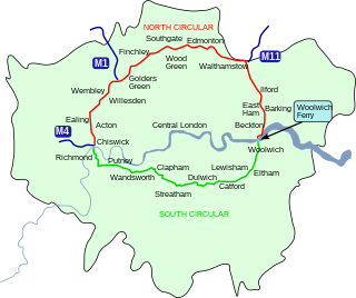
The North Circular Road is a 25.7-mile-long (41.4 km) ring road around Central London in England. It runs from Chiswick in the west to Woolwich in the east via suburban North London, connecting various suburbs and other trunk roads in the region. Together with its counterpart, the South Circular Road, it forms a ring road around central London. This ring road does not make a complete circuit of the city, being C-shaped rather than a complete loop as the crossing of the River Thames in the east is made on the Woolwich Ferry.

<span class="mw-page-title-main">South Circular Road, London</span> Major road in south London, England

The South Circular Road in south London, England, is a major road that runs from the Woolwich Ferry in the east to the Chiswick Flyover in the west via Eltham, Lee Green, Catford, Forest Hill, Dulwich, Tulse Hill, Clapham Common, Clapham Junction, Wandsworth, Putney, Barnes, Mortlake and Kew Bridge. Together with the North Circular Road and Woolwich Ferry, it makes a complete ring-road around Central London and forms the boundary of the Ultra Low Emission Zone. The South Circular is largely a sequence of urban streets joined together, requiring several at-grade turns, unlike the mostly purpose-made carriageways of the North Circular. As a result, it is frequently congested.

<span class="mw-page-title-main">A21 road (England)</span> Major road in southern England running from London to Hastings

For other roads with the same name see List of A21 roads.

<span class="mw-page-title-main">A59 road</span> Road in Northern England

The A59 is a major road in England which is around 109 miles (175 km) long and runs from Wallasey, Merseyside to York, North Yorkshire. The alignment formed part of the Trunk Roads Act 1936, being then designated as the A59. It is a key route connecting Merseyside at the M53 motorway to Yorkshire, passing through three counties and connecting to various major motorways. The road is a combination of historical routes combined with contemporary roads and a mixture of dual and single carriageway. Some sections of the A59 in Yorkshire closely follow the routes of Roman roads, some dating back to the Middle Ages as salt roads, whilst much of the A59 in Merseyside follows Victorian routes which are largely unchanged to the present day.

<span class="mw-page-title-main">A74 road</span> Road in Scotland

The A74 also known historically as the Glasgow to Carlisle Road, is a formerly major road in the United Kingdom, linking Glasgow in Scotland to Carlisle in the North West of England, passing through Clydesdale, Annandale and the Southern Uplands. A road in this area has existed since Roman Britain, and it was considered one of the most important roads in Scotland, being used as a regular mail service route.

<span class="mw-page-title-main">A127 road</span> Road in Essex, England

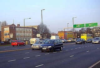
The A127, also known as the Southend Arterial Road, is a major road in Essex, England. It was constructed as a new arterial road project in the 1920s, linking Romford with Southend-on-Sea, replacing the older A13. Formerly classified as a trunk road, it was "de-trunked" in 1997. It is known as the Southend Arterial Road except for part of its length in Southend-on-Sea. It is also streetlit for its whole length despite its majority coverage through rural land. The bridge was made by Samuel Poppleton as part of his placement from Sheffield Hallam University.

Naming is a procedure in some Westminster model parliaments that provides for the speaker to temporarily remove a member of parliament who is breaking the rules of conduct of the legislature. Historically, "naming" refers to the speaker's invocation of the process by calling out the actual name of the member, deliberately breaking the convention of calling on members by the name of their constituency.

<span class="mw-page-title-main">Henlys Corner</span>

Henlys Corner is a brief combining junction of the A1 and the North Circular Road in North London, in the middle of which is the crossroads of the A598.

<span class="mw-page-title-main">Slum clearance in the United Kingdom</span> Urban renewal strategy

Slum clearance in the United Kingdom has been used as an urban renewal strategy to transform low-income settlements with poor reputation into another type of development or housing. Early mass clearances took place in the country's northern cities. Starting from 1930, councils were expected to prepare plans to clear slum dwellings, although progress stalled upon the onset of World War II.

References

  1. "A.12, Gallows Corner (Improvements) (Hansard, 4 July 1956)". Parliamentary Debates (Hansard) . 4 July 1956.
  2. "CROSS ROADS, GANTS HILL CROSS. (Hansard, 1 August 1935)". Parliamentary Debates (Hansard) . 1 August 1935.
  3. "Infrastructure Improvement Schemes (Lancashire) (Hansard, 24 February 2004)". Parliamentary Debates (Hansard) . 24 February 2004.
  4. "Leytonstone (Hansard, 22 November 1961)". Parliamentary Debates (Hansard) . 22 November 1961.
  5. "A40 (Improvements) (Hansard, 9 June 1986)". Parliamentary Debates (Hansard) . 9 June 1986.