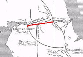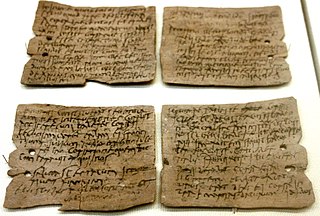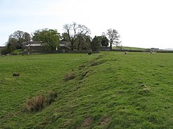
Vindolanda was a Roman auxiliary fort (castrum) just south of Hadrian's Wall in northern England, which it pre-dated. Archaeological excavations of the site show it was under Roman occupation from roughly 85 AD to 370 AD. Located near the modern village of Bardon Mill in Northumberland, it guarded the Stanegate, the Roman road from the River Tyne to the Solway Firth. It is noted for the Vindolanda tablets, a set of wooden leaf-tablets that were, at the time of their discovery, the oldest surviving handwritten documents in Britain.

There are many Roman sites in Great Britain that are open to the public. There are also many sites that do not require special access, including Roman roads, and sites that have not been uncovered.

The Stanegate was an important Roman road and early frontier built in what is now northern England. It linked many forts including two that guarded important river crossings: Corstopitum (Corbridge) on the River Tyne in the east and Luguvalium (Carlisle) in the west. The Stanegate ran through the natural gap formed by the valleys of the River Tyne in Northumberland and the River Irthing in Cumbria. It predated the Hadrian's Wall frontier by several decades; the Wall would later follow a similar route, albeit slightly to the north.
Lucius Neratius Marcellus was an imperial Roman military officer and senator who held a number of posts in the Emperor's service. Marcellus was elected consul twice, first under Domitian in 95 AD and again under Hadrian in 129. His life provides several examples of how patronage operated in early Imperial Rome.

Housesteads Roman Fort was an auxiliary fort on Hadrian's Wall, at Housesteads, Northumberland, England. It is dramatically positioned on the end of the mile-long crag of the Whin Sill over which the Wall runs, overlooking sparsely populated hills. It was called the "grandest station" on the Wall and is one of the best-preserved and extensively displayed forts. It was occupied for almost 300 years. It was located 5.3 miles west from Carrawburgh fort, 6 miles east of Great Chesters fort and about two miles north east of the existing fort at Vindolanda on the Stanegate road.

Eric Barff Birley,, was a British historian and archaeologist, particularly associated with the excavation of the forts of Hadrian's Wall, notably at Vindolanda.

The Vindolanda tablets were, at the time of their discovery, the oldest surviving handwritten documents in Britain. They are a rich source of information about life on the northern frontier of Roman Britain. Written on fragments of thin, postcard-sized wooden leaf-tablets with carbon-based ink, the tablets date to the 1st and 2nd centuries AD. Although similar records on papyrus were known from elsewhere in the Roman Empire, wooden tablets with ink text had not been recovered until 1973, when archaeologist Robin Birley, his attention being drawn by student excavator Keith Liddell, discovered some at the site of Vindolanda, a Roman fort in northern England.
Luguvalium was an ancient Roman city in northern Britain located within present-day Carlisle, Cumbria, and may have been the capital of the 4th-century province of Valentia. It was the northernmost city of the Roman Empire.

Cilurnum or Cilurvum was an ancient Roman fort on Hadrian's Wall at Chesters near the village of Walwick, Northumberland. It is also known as Walwick Chesters to distinguish it from Great Chesters fort and Halton Chesters.
Robin Edgar Birley was a British archaeologist. He was the Director of Excavations at the Roman site of Vindolanda and head of the Vindolanda research committee. He was the son of Eric Birley and brother of Anthony Birley. His wife Patricia Birley and son Andrew Birley are also published authors on Roman Vindolanda.

Andrew Robin Birley is a British archaeologist and the Director of Excavations on the site of Vindolanda. He is the son of Robin Birley and grandson of Eric Birley, who founded the department of Archaeology at Durham University. He graduated from the University of Leicester in the summer of 1996 and has been working on the site for 18 years, ten of which have been in full-time employment by the Vindolanda Trust.

Coria was a fort and town 2.5 miles (4.0 km) south of Hadrian's Wall, in the Roman province of Britannia on the junction of a major Roman north–south road with the River Tyne and another Roman road (Stanegate), the first frontier line which ran east–west between Coria and Luguvalium. Corbridge Roman Site is in the village of Corbridge in the county of Northumberland.

The Vallum is a huge earthwork associated with Hadrian's Wall in England. Unique on any Roman frontier, it runs practically from coast to coast to the south of the wall. It was built a few years after the Wall.

Uxelodunum was a Roman fort with associated civilian settlement (vicus) in modern-day Carlisle, Cumbria, England. It was the largest fort on Hadrian's Wall and is now buried beneath the suburb of Stanwix.

Hadrian's Wall is a former defensive fortification of the Roman province of Britannia, begun in AD 122 in the reign of the Emperor Hadrian. Running from Wallsend on the River Tyne in the east to Bowness-on-Solway in the west of what is now northern England, it was a stone wall with large ditches in front of it and behind it that crossed the whole width of the island. Soldiers were garrisoned along the line of the wall in large forts, smaller milecastles, and intervening turrets. In addition to the wall's defensive military role, its gates may have been customs posts.

The Antonine Wall was a turf fortification on stone foundations, built by the Romans across what is now the Central Belt of Scotland, between the Firth of Clyde and the Firth of Forth. Built some twenty years after Hadrian's Wall to the south, and intended to supersede it, while it was garrisoned it was the northernmost frontier barrier of the Roman Empire. It spanned approximately 63 kilometres and was about 3 metres high and 5 metres wide. Lidar scans have been carried out to establish the length of the wall and the Roman distance units used. Security was bolstered by a deep ditch on the northern side. It is thought that there was a wooden palisade on top of the turf. The barrier was the second of two "great walls" created by the Romans in Great Britain in the second century AD. Its ruins are less evident than those of the better-known and longer Hadrian's Wall to the south, primarily because the turf and wood wall has largely weathered away, unlike its stone-built southern predecessor.

Brian Dobson was an English archaeologist, teacher and scholar. His specialisms were Hadrian's Wall and the Roman Army. He studied under Eric Birley and is a member of the so-called 'Durham School' of archaeology. He was a Reader Emeritus of Durham University.

Roman Cumbria was an area that lay on the north-west frontier of Roman Britain, and, indeed, of the Roman Empire itself.. Interest in the Roman occupation of the region lies in this frontier aspect: why did the Romans choose to occupy the north-west of England; why build a solid barrier in the north of the region ; why was the region so heavily militarised; to what extent were the native inhabitants "Romanised" compared to their compatriots in southern England?

Brenda Swinbank was an English archaeologist. She was one of the first women in Britain to become a professional archaeologist, specialising in the study of Hadrian's Wall, and was instrumental in bringing to publication excavations under York Minster.
Cohors I Hamiorum sagittariorum was a Roman auxiliary infantry unit of archers raised near the ancient city of Hama, Syria. It was a cohors quingenaria consisting of 480 men. The unit's origins are unknown and it is unclear when the unit was first created; however, its existence can be definitively attested in the reign of Hadrian. Military diplomas from the years 122, 124, 127, and 135 AD show that the unit was stationed in Britannia at Magnis (Carvoran). It is the only regiment of archers known to be stationed in Britain. The unit was transferred to Caledonia sometime during the reign of Antoninus Pius according to three inscriptions found at the Bar Hill Fort on the Antonine Wall. In 163 or 164 AD, the regiment was transferred back to Carvoran.


