Milecastle 76

Last updated

Milecastle 76
Drumburgh village - geograph.org.uk - 3492245.jpg
Milecastle 76 lies near the road leading west into Drumburgh
Cumbria UK location map.svg
Red pog.svg
Location within Cumbria
Type Milecastle
Location
Coordinates 54°55′41″N3°08′44″W / 54.92815°N 3.145589°W / 54.92815; -3.145589
CountyCumbria
CountryEngland
Reference
UK-OSNG reference NY26685987

Milecastle 76 (Drumburgh) was one of a series of Milecastles or small fortlets built at intervals of approximately one Roman mile along Hadrian's Wall (grid reference NY26685987 ).

Contents

Description

Milecastle 76 is thought to lie on the east side of the village of Drumburgh, about 200 metres east of the site of Drumburgh Roman fort ( Concavata ). The exact location has not been confirmed. [1] There is said to be a faint platform near this location, but it is doubtful whether it is the remains of the milecastle. [2]

About 100 metres to the east it is claimed that remains of Hadrian's Wall were seen submerged in the marsh in 1962. [3]

Associated turrets

Each milecastle on Hadrian's Wall had two associated turret structures. These turrets were positioned approximately one-third and two-thirds of a Roman mile to the west of the Milecastle, and would probably have been manned by part of the milecastle's garrison. The turrets associated with Milecastle 76 are known as Turret 76A and Turret 76B.

Turret 76A (Drumburgh) (grid reference NY26205997 ) was identified on the ground in 1948. [4] It is said to be located just east of "Drumburgh schoolhouse". [1] There are no visible traces of the turret above ground. [4]

Turret 76B (grid reference NY258602 ) has never been located. Its position has been calculated by reference to neighbouring structures on Hadrian's Wall, and it is thought to be located 90 metres south of where the dismantled railway crosses Hadrian's Wall east of Glasson. [1]

Related Research Articles

<span class="mw-page-title-main">Milecastle 49</span>

<span class="mw-page-title-main">Milecastle 80</span>

Milecastle 80 was one of a series of Milecastles or small fortlets built at intervals of approximately one Roman mile along Hadrian's Wall.

<span class="mw-page-title-main">Milecastle 79</span>

Milecastle 79 (Solway House) was one of a series of Milecastles or small fortlets built at intervals of approximately one Roman mile along Hadrian's Wall (grid reference NY23596224).

<span class="mw-page-title-main">Milecastle 78</span>

Milecastle 78 (Kirkland) was one of a series of Milecastles or small fortlets built at intervals of approximately one Roman mile along Hadrian's Wall (grid reference NY245613).

<span class="mw-page-title-main">Milecastle 77</span>

Milecastle 77 (Raven Bank) was one of a series of Milecastles or small fortlets built at intervals of approximately one Roman mile along Hadrian's Wall (grid reference NY25666068).

<span class="mw-page-title-main">Milecastle 75</span>

Milecastle 75 (Easton) was one of a series of Milecastles or small fortlets built at intervals of approximately one Roman mile along Hadrian's Wall in England (grid reference NY28125975).

<span class="mw-page-title-main">Milecastle 74</span>

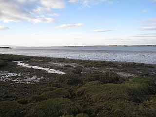
Milecastle 74 (Burgh Marsh) was one of a series of milecastles or small fortlets built at intervals of approximately one Roman mile along Hadrian's Wall (grid reference NY29575965).

<span class="mw-page-title-main">Milecastle 73</span>

Milecastle 73 (Dykesfield) was one of a series of Milecastles or small fortlets built at intervals of approximately one Roman mile along Hadrian's Wall (grid reference NY30975937).

<span class="mw-page-title-main">Milecastle 72</span>

Milecastle 72 (Fauld Farm) was one of a series of Milecastles or small fortlets built at intervals of approximately one Roman mile along Hadrian's Wall (grid reference NY32415913).

<span class="mw-page-title-main">Milecastle 71</span>

Milecastle 71 (Wormanby) was one of a series of Milecastles or small fortlets built at intervals of approximately one Roman mile along Hadrian's Wall (grid reference NY33805920).

<span class="mw-page-title-main">Milecastle 42</span>

Milecastle 42 (Cawfields) is a milecastle on Hadrian's Wall (grid reference NY7157466692).

<span class="mw-page-title-main">Milecastle 40</span>

Milecastle 40 (Winshields) was a milecastle on Hadrian's Wall (grid reference NY74566758).

<span class="mw-page-title-main">Milecastle 54</span>

Milecastle 54 (Randylands) was a milecastle on Hadrian's Wall (grid reference NY55066444).

<span class="mw-page-title-main">Milecastle 56</span>

Milecastle 56 (Walton) was a milecastle on Hadrian's Wall (grid reference NY522643).

<span class="mw-page-title-main">Milecastle 57</span>

Milecastle 57 (Cambeckhill) was a milecastle on Hadrian's Wall (grid reference NY50816368).

<span class="mw-page-title-main">Milecastle 58</span>

Milecastle 58 (Newtown) was a milecastle on Hadrian's Wall (grid reference NY49786258).

<span class="mw-page-title-main">Milecastle 59</span>

Milecastle 59 (Old Wall) was a milecastle on Hadrian's Wall (grid reference NY48546174).

Milecastle 64 (Drawdykes) was a milecastle on Hadrian's Wall (grid reference NY41775874).

Milecastle 65 (Tarraby) was a milecastle on Hadrian's Wall (grid reference NY40855793).

<span class="mw-page-title-main">Milecastle 70</span>

Milecastle 70 (Braelees) was one of a series of Milecastles or small fortlets built at intervals of approximately one Roman mile along Hadrian's Wall (grid reference NY35155898).

References

  1. 1 2 3 Historic England, "Drumburgh Roman fort and Hadrian's Wall between Burgh Marsh and Westfield House in wall miles 76 and 77 (1014699)", National Heritage List for England , retrieved 19 December 2013
  2. Historic England, "Milecastle 76 (10017)", Research records (formerly PastScape), retrieved 19 December 2013
  3. Historic England, "Hadrian's Wall (1011470)", Research records (formerly PastScape), retrieved 4 January 2014
  4. 1 2 Historic England, "Turret 76A (10014)", Research records (formerly PastScape), retrieved 19 December 2013