Milecastle 57

Last updated

Milecastle 57
Cambeckhill - geograph.org.uk - 269428.jpg
Milecastle 57 is thought to lie under Cambeckhill Farm
Cumbria UK location map.svg
Red pog.svg
Location within Cumbria
Type Milecastle
Location
Coordinates 54°57′55″N2°46′11″W / 54.965351°N 2.769748°W / 54.965351; -2.769748
CountyCumbria
CountryEngland
Reference
UK-OSNG reference NY50816368

Milecastle 57 (Cambeckhill) was a milecastle on Hadrian's Wall (grid reference NY50816368 ).

Contents

Description

The exact location of Milecastle 57 is not known. [1] Its position has been estimated in relation to the neighbouring turrets, and it is thought to be located below the farm at Cambeckhill. [2]

In the 1960s an exploratory trench was dug by the Ministry of Public Building and Works before a new barn was erected in the farmyard of Cambeckhill Farm. [1] The excavations found the foundations of Hadrian's Wall, consisting of red sandstone blocks and rubble. [1] Elsewhere the course of Hadrian's Wall is indicated by a broad swelling in the field to the southwest of Cambeckhill farm and as occasional rises in hedgelines which cross its course. [2] The site of the Roman fort at Castlesteads ( Camboglanna ) is situated 430 metres southeast of Milecastle 57. [3]

Associated turrets

Hadrian's Wall Path in the vicinity of Turret 57A Walking towards The Beck Farm - geograph.org.uk - 2886469.jpg
Hadrian's Wall Path in the vicinity of Turret 57A
Turret 57B is thought to lie in the fields northeast of Newtown Farm Fields at Newtown Farm - geograph.org.uk - 3502862.jpg
Turret 57B is thought to lie in the fields northeast of Newtown Farm

Each milecastle on Hadrian's Wall had two associated turret structures. These turrets were positioned approximately one-third and two-thirds of a Roman mile to the west of the Milecastle, and would probably have been manned by part of the milecastle's garrison. The turrets associated with Milecastle 57 are known as Turret 57A and Turret 57B.

Turret 57A

Turret 57A (Beck) (grid reference NY50456333 ) is situated about 180 metres southwest of Dodgson's Beck. [2] It was excavated in 1933. [4] The excavations confirmed that it was a Turf Wall turret, and it measured 6.1 by 6.9 metres. [4] Much pottery was found including Samian ware. [4] The site of Turret 57A is visible only as a slight swelling in the ground. [2]

Turret 57B

Turret 57B (grid reference NY50156293 ) has never been located. [5] Its approximate position has been calculated in relation to other structures on Hadrian's Wall, and it is thought to be situated about 110 metres northeast of Newtown Farm. [2]

Related Research Articles

<span class="mw-page-title-main">Milecastle 49</span>

Milecastle 49 (Harrows Scar) was a milecastle on Hadrian's Wall (grid reference NY6202866407).

<span class="mw-page-title-main">Milecastle 80</span>

Milecastle 80 was one of a series of Milecastles or small fortlets built at intervals of approximately one Roman mile along Hadrian's Wall.

<span class="mw-page-title-main">Milecastle 79</span>

Milecastle 79 (Solway House) was one of a series of Milecastles or small fortlets built at intervals of approximately one Roman mile along Hadrian's Wall (grid reference NY23596224).

<span class="mw-page-title-main">Milecastle 78</span>

Milecastle 78 (Kirkland) was one of a series of Milecastles or small fortlets built at intervals of approximately one Roman mile along Hadrian's Wall (grid reference NY245613).

<span class="mw-page-title-main">Milecastle 76</span>

Milecastle 76 (Drumburgh) was one of a series of Milecastles or small fortlets built at intervals of approximately one Roman mile along Hadrian's Wall (grid reference NY26685987).

<span class="mw-page-title-main">Milecastle 72</span>

Milecastle 72 (Fauld Farm) was one of a series of Milecastles or small fortlets built at intervals of approximately one Roman mile along Hadrian's Wall (grid reference NY32415913).

<span class="mw-page-title-main">Milecastle 71</span>

Milecastle 71 (Wormanby) was one of a series of Milecastles or small fortlets built at intervals of approximately one Roman mile along Hadrian's Wall (grid reference NY33805920).

<span class="mw-page-title-main">Milecastle 42</span>

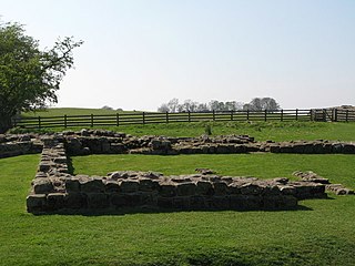
Milecastle 42 (Cawfields) is a milecastle on Hadrian's Wall (grid reference NY7157466692).

<span class="mw-page-title-main">Milecastle 40</span>

Milecastle 40 (Winshields) was a milecastle on Hadrian's Wall (grid reference NY74566758).

<span class="mw-page-title-main">Milecastle 54</span>

Milecastle 54 (Randylands) was a milecastle on Hadrian's Wall (grid reference NY55066444).

<span class="mw-page-title-main">Milecastle 55</span>

Milecastle 55 (Low Wall) was a milecastle on Hadrian's Wall (grid reference NY53596437).

<span class="mw-page-title-main">Milecastle 56</span>

Milecastle 56 (Walton) was a milecastle on Hadrian's Wall (grid reference NY522643).

<span class="mw-page-title-main">Milecastle 58</span>

Milecastle 58 (Newtown) was a milecastle on Hadrian's Wall (grid reference NY49786258).

<span class="mw-page-title-main">Milecastle 59</span>

Milecastle 59 (Old Wall) was a milecastle on Hadrian's Wall (grid reference NY48546174).

<span class="mw-page-title-main">Milecastle 60</span>

Milecastle 60 (High Strand) was one of a series of Milecastles or small fortlets built at intervals of approximately one Roman mile along Hadrian's Wall (grid reference NY47196140).

<span class="mw-page-title-main">Milecastle 61</span>

Milecastle 61 (Wallhead) was a milecastle on Hadrian's Wall (grid reference NY45586088).

Milecastle 64 (Drawdykes) was a milecastle on Hadrian's Wall (grid reference NY41775874).

Milecastle 65 (Tarraby) was a milecastle on Hadrian's Wall (grid reference NY40855793).

<span class="mw-page-title-main">Milecastle 50TW</span>

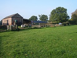
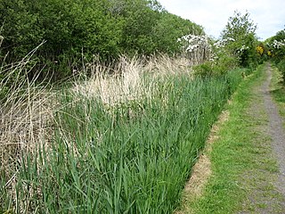
Milecastle 50TW (High House) was a milecastle on the Turf Wall section of Hadrian's Wall (grid reference NY60716583). The milecastle is located close to the Birdoswald Roman Fort and is unique in that it was not replaced by a stone milecastle when the turf wall was upgraded to stone, the replacement wall instead running some 200m to the north. The milecastle was partially demolished by the Romans after it was abandoned. The milecastle was excavated in 1934 and several Roman rubbish pits discovered. The remains of the two turrets associated with this milecastle (which were demolished when the turf wall was abandoned) have also been located. As the turf wall lies some distance from the stone wall, the sites are not accessible from the Hadrian's Wall Path.

<span class="mw-page-title-main">Milecastle 70</span>

Milecastle 70 (Braelees) was one of a series of Milecastles or small fortlets built at intervals of approximately one Roman mile along Hadrian's Wall (grid reference NY35155898).

References

  1. 1 2 3 Historic England, "Milecastle 57 (12795)", Research records (formerly PastScape), retrieved 9 December 2013
  2. 1 2 3 4 5 Historic England, "Hadrian's Wall between the Cam Beck and Newtown Farm in wall miles 56 and 57 (1010986)", National Heritage List for England , retrieved 9 December 2013
  3. Historic England, "Castlesteads Roman Fort (12824)", Research records (formerly PastScape), retrieved 8 December 2013
  4. 1 2 3 Historic England, "Turret 57A (12829)", Research records (formerly PastScape), retrieved 9 December 2013
  5. Historic England, "Turret 57B (12843)", Research records (formerly PastScape), retrieved 9 December 2013