Sainikpuri is a residential neighbourhood in the northeastern part of Hyderabad City. It falls under Kapra mandal of Medchal-Malkajgiri District, and is currently administered under GHMC East Zone. It started as a co-operative housing society venture for retired army personnel, but now has houses which belong to other defence services as well as civilians. Late Brig M. K Rao, Late Brig S.N.Docca and Late Lt. Col. Tiwari Singh were the first few to have got plots in the society and had a vision to develop the colony into an elite area. The housing plots originally allotted to the members of the Sainikpuri co-operative society were of the size of 700–1,000 square yards each. Owing to this reason, most residences have large lawns and gardens. Roads are well laid and numbered. Avenues are lined with a variety of flowering and fruiting trees, and are ideal for morning and evening walks. The sprawling cantonment area, as well as The College of Defence Management (CDM) which is a premier establishment of the Indian armed forces, are in the vicinity of Sainikpuri. The old buildings are now slowly giving way to multi-storied apartments, and it is becoming a costlier affair to acquire living space in this area.

Safilguda originally named as Safilgudem before (1970's) is a residential locality in Neredmet neighbourhood of Hyderabad city. It falls under Malkajgiri mandal in Medchal-Malkajgiri district of Indian state of Telangana. It formed Ward No. 137 of Greater Hyderabad Municipal Corporation in 2009.
Malkajgiri also known as Mallikarjuna Giri is a suburb of Hyderabad, Telangana, India. It is located in Medchal–Malkajgiri district and also Sub-District in Medchal District is the headquarters of Malkajgiri mandal in Malkajgiri revenue division. Erstwhile Malkajgiri Major Grampanchayat was upgraded to a municipality in 1965 and became a municipal corporation in 1985. It was merged into the Greater Hyderabad Municipal Corporation in 2007. It was a part of Ranga Reddy district before the re-organisation of districts in 2016.
Siddipet is a city in the Indian state of Telangana. It is a municipality and serves as the headquarters of Siddipet district. It is located about 100 kilometres (62 mi) north of the state capital, Hyderabad, and 92 kilometres (57 mi) from Warangal. The District Headquarters and police Commissionerate is located at Siddipet City.

Koti is a locality in the city of Hyderabad, Telangana, India. It is one of the best-known commercial Old Suburbs of Hyderabad. There are two areas in the vicinity: King Koti and Ram Koti.
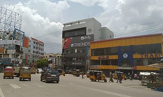
Kamala Nagar is a suburb in Hyderabad. It is located close to ECIL and NFC.
Anandbagh is a locality and a ward in Malkajgiri suburb of Hyderabad city. It falls under the Malkajgiri mandal of the Medchal-Malkajgiri district of the Indian State of Telangana. It is administered as Ward No. 139 of the Greater Hyderabad Municipal Corporation.

Ghatkesar is a satellite town of Hyderabad in the Medchal-Malkajgiri district of Telangana, India. It is the mandal headquarters of Ghatkesar Mandal in the Keesara revenue division. Located in the outer suburbs of Hyderabad, it is a part of the Hyderabad Metropolitan Development Authority.

Keesara, also known by its ancient name Kesarigiri, is a major village and mandal headquarters in the Medchal-Malkajgiri district of the Indian state of Telangana. It is the mandal and divisional headquarters of Keesara mandal in Keesara revenue division and also outer suburb of Hyderabad, also a part of Hyderabad Metropolitan Region. It is located near Outer Ring Road, Hyderabad. It is in the center of Shamirpet - Keesara - Ghatkesar, ECIL - Keesara - Bommalaramaram - M.Turkapalli Routes. It also a part of Hyderabad Metropolitan Development Authority.

Moula-Ali commonly known as Moula Ali. It is a well-developed industrial and urban area in Malkajgiri Mandal, of the Medchal-Malkajgiri district, It is a part of Greater Hyderabad and also a part of Hyderabad Metropolitan Region of the Indian state of Telangana, This area is well connected with rail transportation through the Moula Ali Railway Station. It is noted for its Moula Ali hill, on top of which stands the Moula Ali Dargah and mosque, dedicated to Ali.
Neredmet is formally known as Neredu Mettu is a residential neighbourhood in Hyderabad, Telangana, India. It falls under Malkajgiri mandal & Circle in Medchal-Malkajgiri district. Neredmet currently serves as the headquarters of Rachakonda Police commissionerate, one of the three police commissionerates of Hyderabad City. It was earlier a part of Malkajgiri Municipality, but now it is administered under Malkajgiri Circle of GHMC-Secunderabad Zone. It forms Ward No. 136- Neredmet (Fully), Ward No. 137- Vinayak Nagar(Fully), Ward No. 138- Moula-Ali(Half), Ward No. 139- East Anandbagh(Partially), Ward No. 140- Malkajgiri (Half), of Greater Hyderabad Municipal Corporation.
A. S. Rao Nagar, also known as Dr. A. S. Rao Nagar, is a major commercial and residential neighbourhood of Hyderabad, Telangana, India. It is located in the north eastern side of the city falling under Kapra Village & Mandal, Medchal-Malkajgiri district. It is administered as Ward No. 2 of Greater Hyderabad Municipal Corporation.
Dammaiguda is anouter suburb of Hyderabad in Medchal-Malkajgiri district in Telangana, India. It falls under Keesara mandal. It is a residential neighbourhood with a lot of independent houses and upcoming real-estate projects.. It comes under Jawaharnagar police station which is just 2 km from Dammaiguda Rajiv crossroad. it is one of the fastest developing areas in Hyderabad.It's pincode is 500083.Many Middle Class People live here and is near to the ORR Exit 08 and 09 and is 10-15 min from ECIL(Electronics Corporation Of India Limited) based on traffic.

Boduppal is a satellite city of Hyderabad and a municipal corporation in Medchal–Malkajgiri District of Telangana, India. It is administered by Boduppal Municipal Corporation. Located at the eastern end of Hyderabad City, it is spread between Nacharam-Mallapur Road and Warangal Highway NH 163. Due to its proximity to Secunderabad and Eastern IT/SEZ of Pocharam, it is emerging as a major residential location in Hyderabad.
Ramakrishnapuram Lake, originally named as Mukidigan Cheruvu, is a lake located in Ramakrishnapuram Hamlet, Neredmet Village, Hyderabad near Ramakistapuram Gate Railway Station. It is home to many migratory birds. The lake is currently facing many problems, including water pollution. GHMC is trying to stop pollution but the efforts are not effective. Migratory birds and other animals are also affected by the pollution.

ECIL X Roads or ECIL Cross Roads is a major commercial center in Hyderabad, Telangana, India. It is an important intersection located between some of the densest residential areas in Secunderabad, including Kushaiguda and Moula Ali. The suburb is named after ECIL Factory located nearby on the road to Cherlapally. A TSRTC Bus Terminal is located beside the crossroads. The roads intersecting here are the Trimulgherry-ECIL road and the Tarnaka-Kushaiguda road that starts at Tarnaka Crossroads on the Inner Ring Road. Radhika Crossroads is another major intersection located just a kilometre away on the Trimulgherry-ECIL road and Moula Ali-Dammaiguda road.
Old Neredmet is a locality and also origin of Neredmet, it also has its own fort, walls, watch tower ruins at Neredmet Gadi (Fort). The neighbourhood of Hyderabad city is in the Indian state of Telangana. It is located in Malkajgiri Mandal in Medchal-Malkajgiri district of the state. Ward No. 140- Malkajgiri (Half). Neredmet Grama Bodrai is at Old Neredmet Village, Neredmet Moodu Gullu is the landmark for Old Neredmet Area.
Vinayak Nagar is a locality and a ward in Neredmet neighbourhood of Hyderabad city. It falls under Malkajgiri mandal of Medchal-Malkajgiri district of Indian State of Telangana. It is administered as Ward No. 137 of Greater Hyderabad Municipal Corporation.
Ramakrishnapuram is a locality in Neredmet in Medchal-Malkajgiri district of Indian State of Telangana. It falls under Malkajgiri mandal. In the past 15 years, this suburb has become an important residential area in the twin cities. Many colonies, townships and apartments came up in this suburb.

